- Austin adopts new map that greatly expands area at risk of wildfire
- CenterPoint Energy accelerates infrastructure improvements ahead of hurricane season
- Carolina Hurricanes playoff tickets go on sale Thursday
- Ask the Meteorologist: Why do tornadoes target Tornado Alley, Dixie Alley?
- Nonprofit closes distribution site that aided thousands after Hurricane Helene
Tornado Watch issued for portions of Charlotte, flash flooding and high winds continues
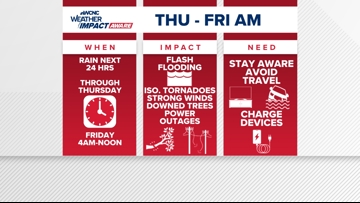
Helene’s impacts move in overnight but this precursor rain has already produced multiple flash flood warnings and a couple of tornado warnings.
CHARLOTTE, N.C. —
Today
Some areas have already seen 2-3″+ (as of 2PM) of rain with a lot more to come. Highs will be in the mid 70s with winds increasing this afternoon and evening. This afternoon will continue to be a soaker and flash flooding will be persistent. Also a chance for isolated tornadoes could spin up at anytime in the afternoon and evening.
There will be a brief break in rain for most of the area around midnight. This is the break before Helene races into the Carolinas.

Friday
Friday morning will have the strongest winds, heaviest rain and the most hazardous conditions. Winds will be strongest to the southwest of Charlotte where some of our viewing area is under a Tropical Storm Watch. Winds here could gust up to 45 to 55+ mph. Some models even showing a chance for gusts up to 65+ mph.
Rain will last the longest to our west but behind this system, there will be a break from the rain for Charlotte starting into the afternoon. Staying breezy with winds up to 30 mph.
Lingering power outages will be an issue. Roads could be closed (mainly for areas west) and multiple trees could fall. Please stay updated and weather aware.
The Weekend
Barring any setbacks, Saturday looks to be the best day of the week. Could be a cloudy start to the day but the afternoon looks to be partly sunny and dry. A few showers possible again during the evening, but most of the day is trending dry.
Sunday will have another chance for showers and even a thunderstorm with highs near 80. Still nothing widespread like what we will see Thursday and Friday.
Raise your Weather IQ
WCNC Charlotte’s Weather IQ YouTube channel gives detailed explainers from the WCNC Charlotte meteorologists to help you learn and understand weather, climate and science. Watch previous stories where you can raise your Weather IQ in the YouTube playlist below and subscribe to get updated when new videos are uploaded.
Stay connected to the WCNC Charlotte Weather Team:
Contact Brad Panovich at bpanovich@wcnc.com or follow him on Facebook, X and Instagram.
Contact Larry Sprinkle at lsprinkle@wcnc.com and follow him on Facebook, X and Instagram.
Contact Chris Mulcahy at cmulcahy@wcnc.com and follow him on Facebook, X, Instagram, and TikTok.
Contact Brittany Van Voorhees at bvanvoorhe@wcnc.com and follow her on Facebook, X and Instagram.
Contact KJ Jacobs at kjacobs3@wcnc.com and follow him on Facebook, X and Instagram.