- McDowell County wildfire spreads to 500 acres, evacuation orders in place
- Evacuations in Caldwell County due to wildfire
- Northwest Houston 'ghost neighborhood' caused by repeated flooding to become latest detention basin
- NHL playoffs: Hurricanes open playoffs Easter Sunday afternoon vs. Devils
- 2 wildfires spreading in rugged terrain in western North Carolina
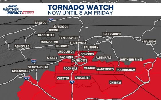
Tornado Watch issued for portions of Charlotte, flash flooding and high winds continue
Helene’s impacts move in overnight but this precursor rain has already produced multiple flash flood warnings and a couple of tornado warnings.
CHARLOTTE, N.C. — Record rainfall fell in Charlotte Thursday with 4.12 inches at the Charlotte Douglas International Airport, as of 9 p.m. This total will likely increase before midnight allowing the actual new record to be much higher.
Overnight
Light-to-moderate rain with isolated downpours will continue through the evening hours across the Charlotte area. There will be a lull around midnight lasting through approximately 5 a.m. as we wait for Helene to arrive.
Flash flooding will be persistent across the mountains, foothills and toward Asheville due to many areas already receiving close to a foot of rain ahead of impacts from Helene.
The highest risk for isolated, spin-up tornadoes will be the early hours on Friday through midday, so be sure to stay weather aware.
Friday
Friday morning will have the most hazardous conditions associated with Helene, as well as leftover impacts from the stalled front. We’ll see the highest risk for tornadoes, highest winds, and heaviest rainfall, so also the worst flash flooding potential.
Winds in Charlotte could gust near 50 mph with even stronger winds toward the mountains and foothills. Conditions will improve drastically throughout the day, although scattered power outages will be likely. Watch for flooded and closed roadways, too, due to multiple trees falling and significant flooding.
Please stay updated and weather aware.
The Weekend
Barring any setbacks, Saturday looks to be the best day of the week! There could be clouds in the morning but sunshine returns in the afternoon. Highs will reach the low 80s with morning temperatures in the low 60s.
A few showers are possible Sunday but overall, it’ll be a nicer day too. Highs peak in the low-mid 80s.
Raise your Weather IQ
WCNC Charlotte’s Weather IQ YouTube channel gives detailed explainers from the WCNC Charlotte meteorologists to help you learn and understand weather, climate and science. Watch previous stories where you can raise your Weather IQ in the YouTube playlist below and subscribe to get updated when new videos are uploaded.
Stay connected to the WCNC Charlotte Weather Team:
Contact Brad Panovich at bpanovich@wcnc.com or follow him on Facebook, X and Instagram.
Contact Larry Sprinkle at lsprinkle@wcnc.com and follow him on Facebook, X and Instagram.
Contact Chris Mulcahy at cmulcahy@wcnc.com and follow him on Facebook, X, Instagram, and TikTok.
Contact Brittany Van Voorhees at bvanvoorhe@wcnc.com and follow her on Facebook, X and Instagram.
Contact KJ Jacobs at kjacobs3@wcnc.com and follow him on Facebook, X and Instagram.