- Dangerous travel conditions: Ice, snow and flooding possible
- How photos lost in disasters like Hurricane Helene find their way home, with a little help from people who care
- Dangerous travel conditions, ice/snow and flooding possible in the mountains Tuesday and Wednesday
- Weather Impact Alert: Dangerous travel conditions, ice/snow and flooding possible in the mountains Tuesday and Wednesday
- North Carolinians perplexed by unexpected DMV refunds tied to Hurricane Helene relief
Dangerous travel conditions: Ice, snow and flooding possible
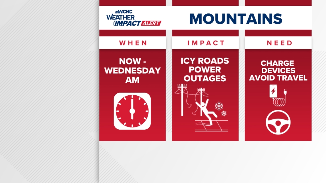
The WCNC Weather Impact Team is encouraging folks in the mountains to stay alert on Wednesday due to the impacts of wintry precipitation.
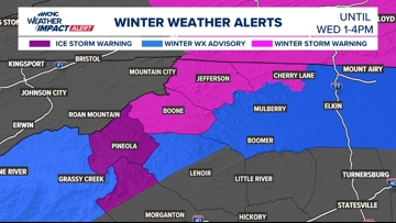
CHARLOTTE, N.C. — The Ice Storm Warning and Winter Weather Advisory has been extended until 1 p.m. and the Winter Storm Warning will remain active for Watauga and Ashe County until 4 p.m.. Freezing rain will switch over to just a cold rain through the morning but the winter weather impacts remain through the first half of the day.
When
MOUNTAINS: North Carolina’s Department of Transportation (NCDOT) has been reporting icy road conditions since Tuesday morning, labeling primary and secondary roads as covered in ice or snow. Those conditions continue through Wednesday morning.

Even after precipitation stops, treacherous driving conditions will remain through the afternoon and evening hours on Wednesday. That’s because temperatures should be above freezing but bridges and overpasses are places where ice could refreeze.
CHARLOTTE: Expect the off-and-on cold rain through Wednesday. The heaviest of this rainfall will be in the morning before ramping back up in the mid-to-late afternoon. This becomes widespread again through the evening and into the early morning hours Thursday. On Thursday, there is even a chance for thunderstorms, which could bring a heavy rain potential.
Impact

Everyone will have the threat of flooding but it is highest for Western North Carolina.
Rainfall accumulations between three and five inches across the mountains, with between two and three inches across the Charlotte metro, could lead to flooding along creeks, streams and in low-lying areas. Periods of heavy rain continue through Thursday morning.
Ways to stay safe
- Keep updated with the forecast and stay off the roads if possible
- Avoid driving and/or traveling to the mountains
- Avoid low-lying areas
- Check GPS ahead of time to see if there are any road closures that could block your commute
Contact Bekah Birdsall at rbirdsall@wcnc.com and follow her on Facebook, X and Instagram.
Contact Chris Mulcahy at cmulcahy@wcnc.com and follow him on Facebook, X, Instagram and TikTok.
Contact Brad Panovich at bpanovich@wcnc.com or follow him on Facebook, X and Instagram.
Contact Larry Sprinkle at lsprinkle@wcnc.com and follow him on Facebook, X and Instagram.
Contact Brittany Van Voorhees at bvanvoorhe@wcnc.com and follow her on Facebook, X and Instagram.