- Weather Impact Alert: Heavy rain could lead to flooding across Carolinas
- North Carolina legislators fleshing out details on $500M in additional Hurricane Helene relief
- Dangerous travel conditions: Ice, snow and flooding possible
- How photos lost in disasters like Hurricane Helene find their way home, with a little help from people who care
- Dangerous travel conditions, ice/snow and flooding possible in the mountains Tuesday and Wednesday
Weather Impact Alert: Heavy rain could lead to flooding across Carolinas
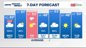
Weather Impact Chief Meteorologist Brad Panovich says periods of heavy rain late Wednesday night could lead to flash flooding across the Charlotte area.
CHARLOTTE, N.C. — Periods of heavy rain and ice are causing treacherous travel conditions in the North Carolina mountains, as well as widespread power outages in the High Country.
Weather Impact Chief Meteorologist Brad Panovich said there is some good news, though. Temperatures are above freezing, which means we’re seeing much less ice in the mountains, where thick accumulation has led to significant power outages in Avery and Watauga counties.
An ice storm warning and winter weather advisory ended at 5 p.m., but a winter storm warning remains in effect for Ashe and Watauga counties is in effect until 7 a.m. Thursday.
Mountains
North Carolina’s Department of Transportation (NCDOT) has been reporting icy road conditions labeling primary and secondary roads as covered in ice or snow. Panovich said power companies in the mountains, including Blue Ridge Electric, warned customers that power may not be restored for a couple of days due to widespread ice that accumulated on tree limbs, roads and power lines.
Treacherous driving conditions will remain through the evening hours on Wednesday even after precipitation stops. That’s because temperatures should be above freezing but bridges and overpasses are places where ice could refreeze. That cold rain will lead to flood concerns and also some wintry mix is still possible overnight for the areas under a Winter Storm Warning.
“The good news is there’s less ice and more rain,” Panovich said. “There’s better weather ahead, at least in the form of ice. Rain will pick up Wednesday night as heavier moisture moves in.”
Charlotte
Rain is expected to continue across the Charlotte metro through Thursday morning. Much like the mountains, good weather is on the way. Panovich said heavy rain will move in Wednesday night with the risk of heavy rain and lightning.
However, Thursday will be a mild day with sunny skies and temperatures near 60 degrees. The warm, dry weather won’t last too long, as showers will move in creating a soggy weekend in the Carolinas. Panovich said there’s also a chance of localized flooding Saturday into Sunday across the Charlotte area.
Impact
Ice and power outages
Everyone will have the threat of flooding but it is highest for Western North Carolina.
Rainfall accumulations between three and five inches across the mountains, with between two and three inches across the Charlotte metro, could lead to flooding along creeks, streams and in low-lying areas. Periods of heavy rain continue through Thursday morning.

Ways to stay safe
- Keep updated with the forecast and stay off the roads if possible
- Avoid driving and/or traveling to the mountains
- Avoid low-lying areas
- Check GPS ahead of time to see if there are any road closures that could block your commute
Contact Bekah Birdsall at rbirdsall@wcnc.com and follow her on Facebook, X and Instagram.
Contact Chris Mulcahy at cmulcahy@wcnc.com and follow him on Facebook, X, Instagram and TikTok.
Contact Brad Panovich at bpanovich@wcnc.com or follow him on Facebook, X and Instagram.
Contact Larry Sprinkle at lsprinkle@wcnc.com and follow him on Facebook, X and Instagram.
Contact Brittany Van Voorhees at bvanvoorhe@wcnc.com and follow her on Facebook, X and Instagram.