- Severe storms, flooding make mess for drivers on the road Sunday
- ‘The safety and well-being of Texans is our No.1 priority’ | Gov. Abbott announces federal aid for resources to fight Texas wildfires
- Crabapple wildfire near Fredericksburg increases to 9,500 acres, still only 40% contained
- Fire crews continue to battle 9,500-acre wildfire near Fredericksburg
- Power outages: Widespread impacts in NC mountains after severe weather outbreak
Heavy rain in Charlotte, tornado risk east of I-77
A tornado watch is in effect for Anson, Chesterfield, Stanly and Richmond counties in the Charlotte area until 2 p.. Sunday.
CHARLOTTE, N.C. — The WCNC Weather Impact Team is tracking a severe weather system pushing into the Charlotte area early Sunday morning with the threat of heavy rain, damaging winds and isolated tornadoes.
As of 8:15 a.m., a second wave of storms was forming in the North Carolina mountains and foothills along Interstate 40. Chief Meteorologist Brad Panovich said heavy rain is expected in the Charlotte metro through around 10 a.m. The secondary line is moving northeast but could impact areas just north of the Queen City.
“Until this line moves through, there’s still the potential for severe weather,” Panovich said.
The biggest risk of severe weather will be south and east of Charlotte. Panovich said areas like Lancaster and Chesterfield counties could see severe weather. A tornado watch is in effect until 2 p.m. for Anson, Chesterfield, Richmond and Stanly counties.
“West of I-77, the severe threat is lessening,” Panovich said. “Just gusty, non-thunderstorm winds. East of I-77, we’re watching the risk increasing with a new tornado watch until 2 p.m.”
This storm system is responsible for at least 32 deaths and numerous tornadoes across the U.S. Deaths have been reported in several states, including Mississippi, Missouri and Arkansas. Several governors issued states of emergency due to the catastrophic damage caused by tornadoes in the Deep South.
When
The main threat of severe weather in Charlotte is until 10 a.m. Gusts up to 52 mph were recorded in the mountains, while most of the Charlotte metro saw gusts ranging from 25-32 mph.
Panovich said heavy rain was falling across the Charlotte area at 8:15 a.m. Those downpours were impacting all of Charlotte and surrounding counties. Lighter rain is falling along I-85 into Rowan County.
Panovich anticipated a tornado watch for the area. The National Weather Service verified those concerns by issuing a tornado watch for Anson, Chesterfield, Richmond and Stanly counties until 2 p.m.
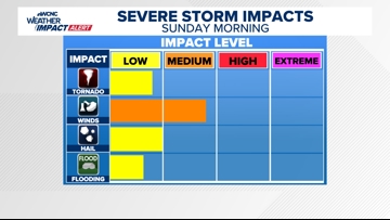
Impact

The impact of this severe weather is heavy rain, damaging winds and tornadoes. There’s a low risk for hail and flooding, according to Panovich.
Need
In order to receive timely severe weather alerts, be sure to have multiple ways to receive weather alerts. One of those ways can be the WCNC Charlotte mobile app. Since the storms could arrive during the early morning hours, be sure to have a weather radio or other tool to awaken you in the event of a nearby storm.
Panovich says everyone should have three ways to receive real-time severe weather alerts. These include wireless emergency alerts that are built into most smartphones, weather apps and a NOAA weather radio that’s set to alarm during a tornado warning or other emergency.