- NC's FEMA aid extension for Hurricane Helene recovery denied
- NC's FEMA aid extension for Hurricane Helene recovery denied
- NC Gov. Stein pledges continued Hurricane Helene recovery support in 100-day address
- Austin adopts new map that greatly expands area at risk of wildfire
- CenterPoint Energy accelerates infrastructure improvements ahead of hurricane season
Ask the Meteorologist: Why do tornadoes target Tornado Alley, Dixie Alley?
Less than 10 days into April, the United States has seen more than 100 reported tornadoes.
Since I started this job in 2014, I’ve oftentimes visited schools, rotary clubs, assisted living centers, etc. One of the questions I get most often is either a) “how do tornadoes form?” or b) “why do tornadoes target certain parts of the country?”
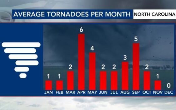
Tornadoes in NC vs. other states
As many of you know, we’re not immune to tornadoes.
We’re just days away from marking 14 years since the April 16, 2011 outbreak.
April and May tend to be one peak for tornado activity in North Carolina. Another peak happens during the climatological peak of hurricane season.
We explain why hurricanes often spawn tornadoes in a previous story.
According to NOAA’s Storm Prediction Center, however, there are certain states that see more tornadoes in a three-month time frame than we see (on average) throughout the entire year.

What is it about Tornado Alley?
Tornado Alley is a commonly known region of the United States in which tornadoes happen most often. April, May and June tend to be the months in which twisters happen most.
A lot of it has to do with its proximity to the Rocky Mountains.
Storm systems are more likely to form here, due to a process known as leeward cyclogenesis, in which the column of air can stretch vertically and spin more (think about a figure skater bringing its arms in).
Temperature and moisture boundaries form as a result.

You have your cold front and your warm front, but you have a boundary unique to those east of the Rockies called a dry line. Where these three boundaries “meet” is called a triple point.

This is where rising air and spin are maximized, which allows multiple tornadoes to spawn.
What about Dixie Alley?
Dixie Alley is a region whose nickname has come up in recent years, thanks to the increasing trend for tornadoes there. This includes states like Mississippi, Alabama, Georgia, Tennessee, Arkansas and Louisiana.
According to Climate Central, some counties see 2-to-4 more tornado days per decade now than they did in the late 1970s. That’s not to say that Tornado Alley is “shifting,” but that more have been observed east of there.

There is no direct link to more frequent tornadoes in this part of the country and something like global warming/climate change.
Rather, you have similar dynamics at play in the atmosphere.
The proximity to the Gulf makes the air very warm and humid at times east of storm systems that move in from the Rockies. This atmosphere here becomes very unstable, which allows parcels of air to rise more rapidly and form strong thunderstorms.

Increasing wind around storm systems in the spring generate more spin. That combination leads to more frequent and (at times) violent tornadoes in this part of the country.
This is also a part of the country where there is an increased mobile home density, which makes the impact of these twisters higher at times than if it were to spin up in a vacant field in the Plains.
Other factors
Nowadays, you have more visuals (smart phone technology and social media) and more methods to report severe weather than you did in the past. This can lead to the increasing trend in observed severe weather, including (but not limited to) tornadoes.
—
Have questions about the weather and how it works?
Send me an email with the subject line ‘Ask the Meteorologist:’ to cmichaels@wral.com.