- Western NC wildfire risk will 'get worse, not better' Ag Commissioner says, pressing lawmakers for help
- Watering trees is a must to protect them from severe weather and drought
- At least 4 dead, hundreds rescued after deadly floods ravage South Texas
- Today on Texas Standard: Deadly floods swamp South Texas, shatter records
- North Carolina radio station was a critical lifeline after Hurricane Helene. Then it became the voice of recovery.
RVs reportedly swept away near Concan after heavy rain; flash flood watch extended in S.A. area
Posted on by WeatherPreppers
Related Post
- Watering trees is a must to protect them from severe weather and drought
- At least 4 dead, hundreds rescued after deadly floods ravage South Texas
- Today on Texas Standard: Deadly floods swamp South Texas, shatter records
- Carolina wildfires grow, evacuation orders still in effect
- 3 dead, flash floods overwhelm South Texas, with some areas receiving more than 12 inches of rain
By Fares Sabawi, mySanAntonio.com
Updated
-
First responders were kept busy with multiple rescue calls after heavy rain flooded the Llano River in Junction.
First responders were kept busy with multiple rescue calls after heavy rain flooded the Llano River in Junction.
Photo: Texas Game Wardens
-
![The South Llano River reached 31 feet in Junction, Texas, Monday morning, causing the river to overflow its banks and essentially drowning a nearby RV Park. Photo: Junction Mayor Russell Hammonds]()
The South Llano River reached 31 feet in Junction, Texas, Monday morning, causing the river to overflow its banks and essentially drowning a nearby RV Park.
The South Llano River reached 31 feet in Junction, Texas, Monday morning, causing the river to overflow its banks and essentially drowning a nearby RV Park.
Photo: Junction Mayor Russell Hammonds
-
![First responders were kept busy with multiple rescue calls after heavy rain flooded the Llano River in Junction. Photo: Texas Game Wardens]()
First responders were kept busy with multiple rescue calls after heavy rain flooded the Llano River in Junction.
First responders were kept busy with multiple rescue calls after heavy rain flooded the Llano River in Junction.
Photo: Texas Game Wardens
-
![The South Llano River reached 31 feet in Junction, Texas, Monday morning, causing the river to overflow its banks and essentially drowning a nearby RV Park. Photo: Junction Mayor Russell Hammonds]()
The South Llano River reached 31 feet in Junction, Texas, Monday morning, causing the river to overflow its banks and essentially drowning a nearby RV Park.
The South Llano River reached 31 feet in Junction, Texas, Monday morning, causing the river to overflow its banks and essentially drowning a nearby RV Park.
Photo: Junction Mayor Russell Hammonds
-
![Texas has been hit with dozens of major floods throughout the years, which have caused hundreds of deaths and billions of dollars in damage. Keep clicking to see the most catastrophic floods in Texas' history, since 1913. Photo: File]() Texas has been hit with dozens of major floods throughout the years, which have caused hundreds of deaths and billions of dollars in damage. Keep clicking to see the most catastrophic floods in Texas’ history, since 1913. lessTexas has been hit with dozens of major floods throughout the years, which have caused hundreds of deaths and billions of dollars in damage. Keep clicking to see the most catastrophic floods in Texas’ history, … more
Texas has been hit with dozens of major floods throughout the years, which have caused hundreds of deaths and billions of dollars in damage. Keep clicking to see the most catastrophic floods in Texas’ history, since 1913. lessTexas has been hit with dozens of major floods throughout the years, which have caused hundreds of deaths and billions of dollars in damage. Keep clicking to see the most catastrophic floods in Texas’ history, … morePhoto: File
-
![During a classic El Nino year in 1913, heavy rains drenched Texas. In this photo, taken during the December 1913 floods, kids wade in feet-high water on St. Mary's Street at Houston Streets. The last tens days in November 1913 saw heavy rains that laid the foundation for flooding during the first five days of December. Rainfall totals measured 20 to 25 inches, causing 180 drownings. Photo: Express-News File Photo]() During a classic El Nino year in 1913, heavy rains drenched Texas. In this photo, taken during the December 1913 floods, kids wade in feet-high water on St. Mary’s Street at Houston Streets. The last tens days in November 1913 saw heavy rains that laid the foundation for flooding during the first five days of December. Rainfall totals measured 20 to 25 inches, causing 180 drownings.
During a classic El Nino year in 1913, heavy rains drenched Texas. In this photo, taken during the December 1913 floods, kids wade in feet-high water on St. Mary’s Street at Houston Streets. The last tens days in November 1913 saw heavy rains that laid the foundation for flooding during the first five days of December. Rainfall totals measured 20 to 25 inches, causing 180 drownings.
lessDuring a classic El Nino year in 1913, heavy rains drenched Texas. In this photo, taken during the December 1913 floods, kids wade in feet-high water on St. Mary’s Street at Houston Streets. The last tens days … morePhoto: Express-News File Photo
-
![The Thrall Flood in 1921 drenched San Antonio due to a tropical storm that formed in the Bay of Campeche. In this photo from Sept. 21, 1921, soldiers float in a boat down St. Mary's Street. During 36 hours, the amount of rainfall stood at 39.7 inches, which drowned 51 people. Photo: Courtesy Photo / Arcadia Publishing]() The Thrall Flood in 1921 drenched San Antonio due to a tropical storm that formed in the Bay of Campeche. In this photo from Sept. 21, 1921, soldiers float in a boat down St. Mary’s Street. During 36 hours, the amount of rainfall stood at 39.7 inches, which drowned 51 people. lessThe Thrall Flood in 1921 drenched San Antonio due to a tropical storm that formed in the Bay of Campeche. In this photo from Sept. 21, 1921, soldiers float in a boat down St. Mary’s Street. During 36 hours, the … more
The Thrall Flood in 1921 drenched San Antonio due to a tropical storm that formed in the Bay of Campeche. In this photo from Sept. 21, 1921, soldiers float in a boat down St. Mary’s Street. During 36 hours, the amount of rainfall stood at 39.7 inches, which drowned 51 people. lessThe Thrall Flood in 1921 drenched San Antonio due to a tropical storm that formed in the Bay of Campeche. In this photo from Sept. 21, 1921, soldiers float in a boat down St. Mary’s Street. During 36 hours, the … morePhoto: Courtesy Photo / Arcadia Publishing
-
![As a result of the Sept. 9-10, 1921 flood, the city decided to build the Olmos Dam to deter flash flooding. This photo shows one of the 13 bridges that were destroyed due to the flood. Photo: Ernst Wilhelm Raba, Courtesy Photo / San Antonio Conservation Society]()
As a result of the Sept. 9-10, 1921 flood, the city decided to build the Olmos Dam to deter flash flooding. This photo shows one of the 13 bridges that were destroyed due to the flood.
As a result of the Sept. 9-10, 1921 flood, the city decided to build the Olmos Dam to deter flash flooding. This photo shows one of the 13 bridges that were destroyed due to the flood.
Photo: Ernst Wilhelm Raba, Courtesy Photo
-
![In 1935, exceptional floods occurred in May on Seco Creek, in June on the Colorado and Nueces Rivers and their tributaries, and in December on Buffalo Bayou. This photo shows a washed out downtown Houston after Buffalo Bayou flooding in December 1935. Photo: Houston Press / Houston Chronicle]() In 1935, exceptional floods occurred in May on Seco Creek, in June on the Colorado and Nueces Rivers and their tributaries, and in December on Buffalo Bayou. This photo shows a washed out downtown Houston after Buffalo Bayou flooding in December 1935.
In 1935, exceptional floods occurred in May on Seco Creek, in June on the Colorado and Nueces Rivers and their tributaries, and in December on Buffalo Bayou. This photo shows a washed out downtown Houston after Buffalo Bayou flooding in December 1935.
lessIn 1935, exceptional floods occurred in May on Seco Creek, in June on the Colorado and Nueces Rivers and their tributaries, and in December on Buffalo Bayou. This photo shows a washed … morePhoto: Houston Press
-
![A flood in May 1949 marked the worst flood in Fort Worth's history, due to the Clear Fork of the Trinity River breaking its levees and spilling into the city. This photo shows an overview of a soaked Fort Worth on May 17, 1949. Photo: Express-News File Photo]() A flood in May 1949 marked the worst flood in Fort Worth’s history, due to the Clear Fork of the Trinity River breaking its levees and spilling into the city. This photo shows an overview of a soaked Fort Worth on May 17, 1949. lessA flood in May 1949 marked the worst flood in Fort Worth’s history, due to the Clear Fork of the Trinity River breaking its levees and spilling into the city. This photo shows an overview of a soaked Fort Worth … more
A flood in May 1949 marked the worst flood in Fort Worth’s history, due to the Clear Fork of the Trinity River breaking its levees and spilling into the city. This photo shows an overview of a soaked Fort Worth on May 17, 1949. lessA flood in May 1949 marked the worst flood in Fort Worth’s history, due to the Clear Fork of the Trinity River breaking its levees and spilling into the city. This photo shows an overview of a soaked Fort Worth … morePhoto: Express-News File Photo
-
![An estimated 11 inches of rain fell on Clear Fork on May 17, 1949, causing the levees to break. Property damages exceeded $10 million, and 10 people were killed. Photo: Express-News File Photo]()
An estimated 11 inches of rain fell on Clear Fork on May 17, 1949, causing the levees to break. Property damages exceeded $10 million, and 10 people were killed.
An estimated 11 inches of rain fell on Clear Fork on May 17, 1949, causing the levees to break. Property damages exceeded $10 million, and 10 people were killed.
Photo: Express-News File Photo
-
![Debris cover a car lot as flood waters, the worst to strike Fort Worth, receded on May 18, 1949. Photo: Express-News File Photo]()
Debris cover a car lot as flood waters, the worst to strike Fort Worth, receded on May 18, 1949.
Debris cover a car lot as flood waters, the worst to strike Fort Worth, receded on May 18, 1949.
Photo: Express-News File Photo
-
![An overview of a flooded Fort Worth on May 17, 1949. Photo: Express-News File Photo]()
An overview of a flooded Fort Worth on May 17, 1949.
An overview of a flooded Fort Worth on May 17, 1949.
Photo: Express-News File Photo
-
![Heavy rain on Sept. 11, 1952, flooded the Pedernales, San Saba, Guadalupe, Comal and Colorado rivers, disrupting the worst drought on record. The flooding of the Colorado River caused Lake Travis to rise 57 feet in 14 hours. Photo: Express-News File Photo]() Heavy rain on Sept. 11, 1952, flooded the Pedernales, San Saba, Guadalupe, Comal and Colorado rivers, disrupting the worst drought on record. The flooding of the Colorado River caused Lake Travis to rise 57 feet in 14 hours. lessHeavy rain on Sept. 11, 1952, flooded the Pedernales, San Saba, Guadalupe, Comal and Colorado rivers, disrupting the worst drought on record. The flooding of the Colorado River caused Lake Travis to rise 57 … more
Heavy rain on Sept. 11, 1952, flooded the Pedernales, San Saba, Guadalupe, Comal and Colorado rivers, disrupting the worst drought on record. The flooding of the Colorado River caused Lake Travis to rise 57 feet in 14 hours. lessHeavy rain on Sept. 11, 1952, flooded the Pedernales, San Saba, Guadalupe, Comal and Colorado rivers, disrupting the worst drought on record. The flooding of the Colorado River caused Lake Travis to rise 57 … morePhoto: Express-News File Photo
-
![Because of the Central Texas floods in September 1952, five people died and 17 homes were destroyed. About 23 to 26 inches of rain fell between Kerrville, Blanco and Boerne. Photo: Express-News File Photo]()
Because of the Central Texas floods in September 1952, five people died and 17 homes were destroyed. About 23 to 26 inches of rain fell between Kerrville, Blanco and Boerne.
Because of the Central Texas floods in September 1952, five people died and 17 homes were destroyed. About 23 to 26 inches of rain fell between Kerrville, Blanco and Boerne.
Photo: Express-News File Photo
-
![Angry flood waters were released from the then-new Alvin J. Wirtz dam in Marble Falls in September 1952, which spans the Colorado River. Photo: Express-News File Photo]()
Angry flood waters were released from the then-new Alvin J. Wirtz dam in Marble Falls in September 1952, which spans the Colorado River.
Angry flood waters were released from the then-new Alvin J. Wirtz dam in Marble Falls in September 1952, which spans the Colorado River.
Photo: Express-News File Photo
-
![A farm house flooded due to high waters in the San Saba River in September 1952. Photo: Express-News File Photo]()
A farm house flooded due to high waters in the San Saba River in September 1952.
A farm house flooded due to high waters in the San Saba River in September 1952.
Photo: Express-News File Photo
-
![A submerged house in New Braunfels due to the flooding of the Guadalupe River in September 1952. Photo: Express-News File Photo]()
A submerged house in New Braunfels due to the flooding of the Guadalupe River in September 1952.
A submerged house in New Braunfels due to the flooding of the Guadalupe River in September 1952.
Photo: Express-News File Photo
-
![On May 25, 1954, Hurricane Alice made landfall on the Rio Grande Valley. The Valley received about 35 inches of rain in 36 hours. Photo: Express-News File Photo]()
On May 25, 1954, Hurricane Alice made landfall on the Rio Grande Valley. The Valley received about 35 inches of rain in 36 hours.
On May 25, 1954, Hurricane Alice made landfall on the Rio Grande Valley. The Valley received about 35 inches of rain in 36 hours.
Photo: Express-News File Photo
-
![In May 1965, rain on the middle Brazos River Basin caused flooding on major tributary streams leading to San Antonio. Rain exceeded six inches, but it was categorized as a severe storm. Photo: Express-News File Photo]()
In May 1965, rain on the middle Brazos River Basin caused flooding on major tributary streams leading to San Antonio. Rain exceeded six inches, but it was categorized as a severe storm.
In May 1965, rain on the middle Brazos River Basin caused flooding on major tributary streams leading to San Antonio. Rain exceeded six inches, but it was categorized as a severe storm.
Photo: Express-News File Photo
-
![The May 1965 flood caused two deaths and $1 million in damage. Photo: Express-News File Photo]()
The May 1965 flood caused two deaths and $1 million in damage.
The May 1965 flood caused two deaths and $1 million in damage.
Photo: Express-News File Photo
-
![A flooded San Antonio River at Berg's Mill on May 18, 1965. Photo: Express-News File Photo]()
A flooded San Antonio River at Berg’s Mill on May 18, 1965.
A flooded San Antonio River at Berg’s Mill on May 18, 1965.
Photo: Express-News File Photo
-
![Pictured here is a flooded Olmos Basin on May 18, 1965, with Olmos Dam in the foreground and the Quarry in the background. Photo: Express-News File Photo]()
Pictured here is a flooded Olmos Basin on May 18, 1965, with Olmos Dam in the foreground and the Quarry in the background.
Pictured here is a flooded Olmos Basin on May 18, 1965, with Olmos Dam in the foreground and the Quarry in the background.
Photo: Express-News File Photo
-
![Arroyo City, a string of houses, bait shops and other stores along the Arroyo Colorado was hard hit by Hurricane Beulah in Sept. 19-25, 1967, and the devastating floods that followed on Oct. 8, 1967. Arroyo City is located near the tip of Texas. Photo: Ted Powers, AP Photo/Ted Powers / AP1967]() Arroyo City, a string of houses, bait shops and other stores along the Arroyo Colorado was hard hit by Hurricane Beulah in Sept. 19-25, 1967, and the devastating floods that followed on Oct. 8, 1967. Arroyo City is located near the tip of Texas.
Arroyo City, a string of houses, bait shops and other stores along the Arroyo Colorado was hard hit by Hurricane Beulah in Sept. 19-25, 1967, and the devastating floods that followed on Oct. 8, 1967. Arroyo City is located near the tip of Texas.
lessArroyo City, a string of houses, bait shops and other stores along the Arroyo Colorado was hard hit by Hurricane Beulah in Sept. 19-25, 1967, and the devastating floods that followed on Oct. 8, 1967. Arroyo … morePhoto: Ted Powers, AP Photo/Ted Powers
-
![Some areas have received over 20 inches of rain as a result of Hurricane Beulah. In this photo, an elderly woman resident of a Harlingen nursing home is rescued to safety by ambulance attendants as flood waters threatened the home and the entire Rio Grande Valley in South Texas, on Sept. 23, 1967. Photo: Anonymous, AP Photo/Ted Powers / AP1967]() Some areas have received over 20 inches of rain as a result of Hurricane Beulah. In this photo, an elderly woman resident of a Harlingen nursing home is rescued to safety by ambulance attendants as flood waters threatened the home and the entire Rio Grande Valley in South Texas, on Sept. 23, 1967.
Some areas have received over 20 inches of rain as a result of Hurricane Beulah. In this photo, an elderly woman resident of a Harlingen nursing home is rescued to safety by ambulance attendants as flood waters threatened the home and the entire Rio Grande Valley in South Texas, on Sept. 23, 1967.
lessSome areas have received over 20 inches of rain as a result of Hurricane Beulah. In this photo, an elderly woman resident of a Harlingen nursing home is rescued to safety by ambulance attendants as flood waters … morePhoto: Anonymous, AP Photo/Ted Powers
-
![In this photo, Ricky Knight, 13, is pulled from the floodwaters in the Parkwood Addition of Harlingen, flooded by the overflowing Arroyo Colorado in Harlingen on Sept. 25, 1967. Because of the floods, roads, bridges, fences, livestock, homes and businesses were destroyed all over south Texas west of Victoria to the Rio Grande Photo: Ted Powers, AP Photo/Ted Powers / AP1967]() In this photo, Ricky Knight, 13, is pulled from the floodwaters in the Parkwood Addition of Harlingen, flooded by the overflowing Arroyo Colorado in Harlingen on Sept. 25, 1967. Because of the floods, roads, bridges, fences, livestock, homes and businesses were destroyed all over south Texas west of Victoria to the Rio Grande lessIn this photo, Ricky Knight, 13, is pulled from the floodwaters in the Parkwood Addition of Harlingen, flooded by the overflowing Arroyo Colorado in Harlingen on Sept. 25, 1967. Because of the floods, roads, … more
In this photo, Ricky Knight, 13, is pulled from the floodwaters in the Parkwood Addition of Harlingen, flooded by the overflowing Arroyo Colorado in Harlingen on Sept. 25, 1967. Because of the floods, roads, bridges, fences, livestock, homes and businesses were destroyed all over south Texas west of Victoria to the Rio Grande lessIn this photo, Ricky Knight, 13, is pulled from the floodwaters in the Parkwood Addition of Harlingen, flooded by the overflowing Arroyo Colorado in Harlingen on Sept. 25, 1967. Because of the floods, roads, … morePhoto: Ted Powers, AP Photo/Ted Powers
-
![In May 14-15, 1970, heavy rains fell on Central Texas, causing 400 homes to severely flood, as well as many more businesses and public buildings. Three elementary schools were also flooded, and some students had to be rescued by a helicopter. Two children drowned when a small aluminum boat they were being rescued in overturned. Photo: Express-News File Photo]() In May 14-15, 1970, heavy rains fell on Central Texas, causing 400 homes to severely flood, as well as many more businesses and public buildings. Three elementary schools were also flooded, and some students had to be rescued by a helicopter. Two children drowned when a small aluminum boat they were being rescued in overturned. lessIn May 14-15, 1970, heavy rains fell on Central Texas, causing 400 homes to severely flood, as well as many more businesses and public buildings. Three elementary schools were also flooded, and some students … more
In May 14-15, 1970, heavy rains fell on Central Texas, causing 400 homes to severely flood, as well as many more businesses and public buildings. Three elementary schools were also flooded, and some students had to be rescued by a helicopter. Two children drowned when a small aluminum boat they were being rescued in overturned. lessIn May 14-15, 1970, heavy rains fell on Central Texas, causing 400 homes to severely flood, as well as many more businesses and public buildings. Three elementary schools were also flooded, and some students … morePhoto: Express-News File Photo
-
![The San Marcos area received the worst of the May 1970 floods. Because of that, five flood-retention dams were built by the NRCS to prevent additional severe flooding. These structures prevented much of the city from being destroyed in the October 1998 flood when 20-30 inches of rain fell. Photo: Express-News File Photo]() The San Marcos area received the worst of the May 1970 floods. Because of that, five flood-retention dams were built by the NRCS to prevent additional severe flooding. These structures prevented much of the city from being destroyed in the October 1998 flood when 20-30 inches of rain fell. lessThe San Marcos area received the worst of the May 1970 floods. Because of that, five flood-retention dams were built by the NRCS to prevent additional severe flooding. These structures prevented much of the … more
The San Marcos area received the worst of the May 1970 floods. Because of that, five flood-retention dams were built by the NRCS to prevent additional severe flooding. These structures prevented much of the city from being destroyed in the October 1998 flood when 20-30 inches of rain fell. lessThe San Marcos area received the worst of the May 1970 floods. Because of that, five flood-retention dams were built by the NRCS to prevent additional severe flooding. These structures prevented much of the … morePhoto: Express-News File Photo
-
![During May 1972, South Central Texas was devastated with torrential rains and major flooding. In this photo, San Antonians stand on Leon Creek, near Culebra and Loop 410. Flash floods crashed throughout the area from May 11-12, 1972. Photo: Express-News File Photo]() During May 1972, South Central Texas was devastated with torrential rains and major flooding. In this photo, San Antonians stand on Leon Creek, near Culebra and Loop 410. Flash floods crashed throughout the area from May 11-12, 1972. lessDuring May 1972, South Central Texas was devastated with torrential rains and major flooding. In this photo, San Antonians stand on Leon Creek, near Culebra and Loop 410. Flash floods crashed throughout the … more
During May 1972, South Central Texas was devastated with torrential rains and major flooding. In this photo, San Antonians stand on Leon Creek, near Culebra and Loop 410. Flash floods crashed throughout the area from May 11-12, 1972. lessDuring May 1972, South Central Texas was devastated with torrential rains and major flooding. In this photo, San Antonians stand on Leon Creek, near Culebra and Loop 410. Flash floods crashed throughout the … morePhoto: Express-News File Photo
-
![In this photo, taken in May 1972, flood waters reached two feet at Olmos Park. Photo: Express-News File Photo]()
In this photo, taken in May 1972, flood waters reached two feet at Olmos Park.
In this photo, taken in May 1972, flood waters reached two feet at Olmos Park.
Photo: Express-News File Photo
-
![The major areas that were affected in the May 1972 floods were the San Antonio and Guadalupe rivers, which received up to 16.5 inches in just two hours. Photo: Express-News File Photo]()
The major areas that were affected in the May 1972 floods were the San Antonio and Guadalupe rivers, which received up to 16.5 inches in just two hours.
The major areas that were affected in the May 1972 floods were the San Antonio and Guadalupe rivers, which received up to 16.5 inches in just two hours.
Photo: Express-News File Photo
-
![In this May 12, 1972 photo, flood waters tore up a railroad track and sent a boxcar off the track near Landa Park in New Braunfels. Rains up to 12 inches struck the area that day. Photo: Express-News File Photo]()
In this May 12, 1972 photo, flood waters tore up a railroad track and sent a boxcar off the track near Landa Park in New Braunfels. Rains up to 12 inches struck the area that day.
In this May 12, 1972 photo, flood waters tore up a railroad track and sent a boxcar off the track near Landa Park in New Braunfels. Rains up to 12 inches struck the area that day.
Photo: Express-News File Photo
-
![Because the Guadalupe and San Antonio river basins were flooded, water roared down the Olmos Basin in May 1972. Photo: Express-News File Photo]()
Because the Guadalupe and San Antonio river basins were flooded, water roared down the Olmos Basin in May 1972.
Because the Guadalupe and San Antonio river basins were flooded, water roared down the Olmos Basin in May 1972.
Photo: Express-News File Photo
-
![Even downtown got wet in May 1972. This photo shows a flooded San Antonio River, looking north to the Houston Street Bridge. Photo: Express-News File Photo]()
Even downtown got wet in May 1972. This photo shows a flooded San Antonio River, looking north to the Houston Street Bridge.
Even downtown got wet in May 1972. This photo shows a flooded San Antonio River, looking north to the Houston Street Bridge.
Photo: Express-News File Photo
-
![This photo, taken in May 1972, shows a flooded Olmos Park golf course. Throughout the flash flood period, 17 people died in New Braunfels and one died in McQueeny. Property damage ranged from $15-$20 million. Photo: Express-News File Photo]()
This photo, taken in May 1972, shows a flooded Olmos Park golf course. Throughout the flash flood period, 17 people died in New Braunfels and one died in McQueeny. Property damage ranged from $15-$20 million.
This photo, taken in May 1972, shows a flooded Olmos Park golf course. Throughout the flash flood period, 17 people died in New Braunfels and one died in McQueeny. Property damage ranged from $15-$20 million.
Photo: Express-News File Photo
-
![In this July 26, 1979, photo, people left the flood area of southeast Houston, and pass by one of many flood victims. The area was hit with heavy rains from the remains of tropical storm Claudette. Photo: Express-News File Photo]()
In this July 26, 1979, photo, people left the flood area of southeast Houston, and pass by one of many flood victims. The area was hit with heavy rains from the remains of tropical storm Claudette.
In this July 26, 1979, photo, people left the flood area of southeast Houston, and pass by one of many flood victims. The area was hit with heavy rains from the remains of tropical storm Claudette.
Photo: Express-News File Photo
-
![From July 25-26, 1979, Tropical Storm Claudette dropped 43 inches of rain on Brazoria County, a populous county south of Houston. In this photo from July 26, 1979, a young victim wears a smile as she is carried from a boat to high ground in the southeast section of Houston. Other rescued persons leave the boat in the background. Photo: Express-News File Photo]() From July 25-26, 1979, Tropical Storm Claudette dropped 43 inches of rain on Brazoria County, a populous county south of Houston. In this photo from July 26, 1979, a young victim wears a smile as she is carried from a boat to high ground in the southeast section of Houston. Other rescued persons leave the boat in the background. lessFrom July 25-26, 1979, Tropical Storm Claudette dropped 43 inches of rain on Brazoria County, a populous county south of Houston. In this photo from July 26, 1979, a young victim wears a smile as she is carried … more
From July 25-26, 1979, Tropical Storm Claudette dropped 43 inches of rain on Brazoria County, a populous county south of Houston. In this photo from July 26, 1979, a young victim wears a smile as she is carried from a boat to high ground in the southeast section of Houston. Other rescued persons leave the boat in the background. lessFrom July 25-26, 1979, Tropical Storm Claudette dropped 43 inches of rain on Brazoria County, a populous county south of Houston. In this photo from July 26, 1979, a young victim wears a smile as she is carried … morePhoto: Express-News File Photo
-
![The next day on July 27, 1979, crews had to rescue people stranded in their flooded homes. During the flood, about 3,000 people were rescued from their homes. Photo: Express-News File Photo]()
The next day on July 27, 1979, crews had to rescue people stranded in their flooded homes. During the flood, about 3,000 people were rescued from their homes.
The next day on July 27, 1979, crews had to rescue people stranded in their flooded homes. During the flood, about 3,000 people were rescued from their homes.
Photo: Express-News File Photo
-
![The final results of the massive amount of rainfall Alvin, a small city south of Houston, received on July 27, 1979. Photo: Express-News File Photo]()
The final results of the massive amount of rainfall Alvin, a small city south of Houston, received on July 27, 1979.
The final results of the massive amount of rainfall Alvin, a small city south of Houston, received on July 27, 1979.
Photo: Express-News File Photo
-
![Heavy rains on Oct. 31, 1981, hit the Dallas area, with Springtown getting the worst of it. In this photo, a Springtown resident takes a break and has a cigarette in his stalled truck. He was stranded by rising waters from heavy rains of 6-10 inches. Photo: Express-News File Photo]() Heavy rains on Oct. 31, 1981, hit the Dallas area, with Springtown getting the worst of it. In this photo, a Springtown resident takes a break and has a cigarette in his stalled truck. He was stranded by rising waters from heavy rains of 6-10 inches. lessHeavy rains on Oct. 31, 1981, hit the Dallas area, with Springtown getting the worst of it. In this photo, a Springtown resident takes a break and has a cigarette in his stalled truck. He was stranded by rising … more
Heavy rains on Oct. 31, 1981, hit the Dallas area, with Springtown getting the worst of it. In this photo, a Springtown resident takes a break and has a cigarette in his stalled truck. He was stranded by rising waters from heavy rains of 6-10 inches. lessHeavy rains on Oct. 31, 1981, hit the Dallas area, with Springtown getting the worst of it. In this photo, a Springtown resident takes a break and has a cigarette in his stalled truck. He was stranded by rising … morePhoto: Express-News File Photo
-
![In this photo, Barry Bobo and Johnny Cannon look in a truck overturned by flood waters in Springtown on Oct. 31, 1981. Due to the rain, the nearby Lake Grapevine reached a high of 563.5 feet, which sent water gushing over its spillway. Photo: Express-News File Photo]() In this photo, Barry Bobo and Johnny Cannon look in a truck overturned by flood waters in Springtown on Oct. 31, 1981. Due to the rain, the nearby Lake Grapevine reached a high of 563.5 feet, which sent water gushing over its spillway. lessIn this photo, Barry Bobo and Johnny Cannon look in a truck overturned by flood waters in Springtown on Oct. 31, 1981. Due to the rain, the nearby Lake Grapevine reached a high of 563.5 feet, which sent water … more
In this photo, Barry Bobo and Johnny Cannon look in a truck overturned by flood waters in Springtown on Oct. 31, 1981. Due to the rain, the nearby Lake Grapevine reached a high of 563.5 feet, which sent water gushing over its spillway. lessIn this photo, Barry Bobo and Johnny Cannon look in a truck overturned by flood waters in Springtown on Oct. 31, 1981. Due to the rain, the nearby Lake Grapevine reached a high of 563.5 feet, which sent water … morePhoto: Express-News File Photo
-
![The Hill Country and South Texas received torrential rain from May to July 1987. This photo, taken on July 17, 1987, shows the Guadalupe River at 16 feet above the flood stage. The rain resulted in the worst flood of the Guadalupe River since 1932. During that summer, San Antonio received 18.45 inches of rain. Photo: Express-News File Photo]() The Hill Country and South Texas received torrential rain from May to July 1987. This photo, taken on July 17, 1987, shows the Guadalupe River at 16 feet above the flood stage. The rain resulted in the worst flood of the Guadalupe River since 1932. During that summer, San Antonio received 18.45 inches of rain. lessThe Hill Country and South Texas received torrential rain from May to July 1987. This photo, taken on July 17, 1987, shows the Guadalupe River at 16 feet above the flood stage. The rain resulted in the worst … more
The Hill Country and South Texas received torrential rain from May to July 1987. This photo, taken on July 17, 1987, shows the Guadalupe River at 16 feet above the flood stage. The rain resulted in the worst flood of the Guadalupe River since 1932. During that summer, San Antonio received 18.45 inches of rain. lessThe Hill Country and South Texas received torrential rain from May to July 1987. This photo, taken on July 17, 1987, shows the Guadalupe River at 16 feet above the flood stage. The rain resulted in the worst … morePhoto: Express-News File Photo
-
![As a result of the July 17, 1987, flood, 10 people died. They were all students who were on a school bus, on their way to a church camp. Thirty other students survived. Photo: Express-News File Photo]()
As a result of the July 17, 1987, flood, 10 people died. They were all students who were on a school bus, on their way to a church camp. Thirty other students survived.
As a result of the July 17, 1987, flood, 10 people died. They were all students who were on a school bus, on their way to a church camp. Thirty other students survived.
Photo: Express-News File Photo
-
![Drenching rains from Tropical Storm Allison drenched Texas from Houston to Dallas in June 1989. In this photo, a motor home in the Houston area is sent afloat. Allison dumped more than 10 inches of rain in the Houston area. Photo: Express-News File Photo]() Drenching rains from Tropical Storm Allison drenched Texas from Houston to Dallas in June 1989. In this photo, a motor home in the Houston area is sent afloat. Allison dumped more than 10 inches of rain in the Houston area. lessDrenching rains from Tropical Storm Allison drenched Texas from Houston to Dallas in June 1989. In this photo, a motor home in the Houston area is sent afloat. Allison dumped more than 10 inches of rain in the … more
Drenching rains from Tropical Storm Allison drenched Texas from Houston to Dallas in June 1989. In this photo, a motor home in the Houston area is sent afloat. Allison dumped more than 10 inches of rain in the Houston area. lessDrenching rains from Tropical Storm Allison drenched Texas from Houston to Dallas in June 1989. In this photo, a motor home in the Houston area is sent afloat. Allison dumped more than 10 inches of rain in the … morePhoto: Express-News File Photo
-
![Glen Gibbons, 27, fishes from the roof of a picnic shelter at Lewisville Lake State Park on June 21, 1989. The park was flooded because of heavy rains from Tropical Storm Allison. Photo: Express-News File Photo]()
Glen Gibbons, 27, fishes from the roof of a picnic shelter at Lewisville Lake State Park on June 21, 1989. The park was flooded because of heavy rains from Tropical Storm Allison.
Glen Gibbons, 27, fishes from the roof of a picnic shelter at Lewisville Lake State Park on June 21, 1989. The park was flooded because of heavy rains from Tropical Storm Allison.
Photo: Express-News File Photo
-
![This photo, taken on May 3, 1990, shows a flooded Guadalupe River in downtown Kerrville. The banks of the river were swollen throughout the Hill Country, as 60 mph winds, tornadoes and baseball-size hail swept through South, Central and East Texas. That spring, nine people died due to storms. Photo: Express-News File Photo]() This photo, taken on May 3, 1990, shows a flooded Guadalupe River in downtown Kerrville. The banks of the river were swollen throughout the Hill Country, as 60 mph winds, tornadoes and baseball-size hail swept through South, Central and East Texas. That spring, nine people died due to storms. lessThis photo, taken on May 3, 1990, shows a flooded Guadalupe River in downtown Kerrville. The banks of the river were swollen throughout the Hill Country, as 60 mph winds, tornadoes and baseball-size hail swept … more
This photo, taken on May 3, 1990, shows a flooded Guadalupe River in downtown Kerrville. The banks of the river were swollen throughout the Hill Country, as 60 mph winds, tornadoes and baseball-size hail swept through South, Central and East Texas. That spring, nine people died due to storms. lessThis photo, taken on May 3, 1990, shows a flooded Guadalupe River in downtown Kerrville. The banks of the river were swollen throughout the Hill Country, as 60 mph winds, tornadoes and baseball-size hail swept … morePhoto: Express-News File Photo
-
![On Oct. 18, 1994, Hurricane Rosa stormed through Texas, from the Pacific, up through Mexico. Massive flooding was reported across the state. Twenty-two in the storms path were killed. Texas was left with $700 million in damages. Photo: Houston Chronicle File Photo]() On Oct. 18, 1994, Hurricane Rosa stormed through Texas, from the Pacific, up through Mexico. Massive flooding was reported across the state. Twenty-two in the storms path were killed. Texas was left with $700 million in damages. lessOn Oct. 18, 1994, Hurricane Rosa stormed through Texas, from the Pacific, up through Mexico. Massive flooding was reported across the state. Twenty-two in the storms path were killed. Texas was left with $700 … more
On Oct. 18, 1994, Hurricane Rosa stormed through Texas, from the Pacific, up through Mexico. Massive flooding was reported across the state. Twenty-two in the storms path were killed. Texas was left with $700 million in damages. lessOn Oct. 18, 1994, Hurricane Rosa stormed through Texas, from the Pacific, up through Mexico. Massive flooding was reported across the state. Twenty-two in the storms path were killed. Texas was left with $700 … morePhoto: Houston Chronicle File Photo
-
![Two unidentified people paddle past a flooded basketball hoop in the central Texas community of Graveyard Point on June 24, 1997, near Lakeway, Texas. This was the third in a series of El Nino related storms moved into the Texas Hill Country in 1997. Photo: KEVIN L. DELAHUNTY, AP Photo / AP]() Two unidentified people paddle past a flooded basketball hoop in the central Texas community of Graveyard Point on June 24, 1997, near Lakeway, Texas. This was the third in a series of El Nino related storms moved into the Texas Hill Country in 1997.
Two unidentified people paddle past a flooded basketball hoop in the central Texas community of Graveyard Point on June 24, 1997, near Lakeway, Texas. This was the third in a series of El Nino related storms moved into the Texas Hill Country in 1997.
lessTwo unidentified people paddle past a flooded basketball hoop in the central Texas community of Graveyard Point on June 24, 1997, near Lakeway, Texas. This was the third in a series of El Nino related storms … morePhoto: KEVIN L. DELAHUNTY, AP Photo
-
![Dewy Cooper looks back while piloting a boat over a flooded road in the central Texas community of Graveyard Point, after helping neighbor Mel Pennington view his flooded home on June 23, 1997. Photo: HARRY CABLUCK, AP Photo / AP]()
Dewy Cooper looks back while piloting a boat over a flooded road in the central Texas community of Graveyard Point, after helping neighbor Mel Pennington view his flooded home on June 23, 1997.
Dewy Cooper looks back while piloting a boat over a flooded road in the central Texas community of Graveyard Point, after helping neighbor Mel Pennington view his flooded home on June 23, 1997.
Photo: HARRY CABLUCK, AP Photo
-
![Surfers take advantage of high surf produced by Tropical Storm Charley on Aug. 22-25, 1998. The storm brought torrential rains and flash floods to the Hill Country. Thirteen people lost their lives and more than 200 were injured. Photo: KIN MAN HUI, Kin Man HUI]() Surfers take advantage of high surf produced by Tropical Storm Charley on Aug. 22-25, 1998. The storm brought torrential rains and flash floods to the Hill Country. Thirteen people lost their lives and more than 200 were injured. lessSurfers take advantage of high surf produced by Tropical Storm Charley on Aug. 22-25, 1998. The storm brought torrential rains and flash floods to the Hill Country. Thirteen people lost their lives and more … more
Surfers take advantage of high surf produced by Tropical Storm Charley on Aug. 22-25, 1998. The storm brought torrential rains and flash floods to the Hill Country. Thirteen people lost their lives and more than 200 were injured. lessSurfers take advantage of high surf produced by Tropical Storm Charley on Aug. 22-25, 1998. The storm brought torrential rains and flash floods to the Hill Country. Thirteen people lost their lives and more … morePhoto: KIN MAN HUI, Kin Man HUI
-
![A rainstorm from Oct. 17–19, 1998, set all-time records for rainfall and river levels, resulting in the death of 25 people, and causing more than $500 million damage from the Hill Country to the counties south and east of San Antonio. In this photo, several rescue boats make their way up Esplanade Street in Cuero, Texas. Floodwaters from the Guadalupe River forced the evacuation of residents living close to the river. Photo: Jerry Lara, Express-News File Photo / SAN ANTONIO EXPRESS-NEWS]() A rainstorm from Oct. 17–19, 1998, set all-time records for rainfall and river levels, resulting in the death of 25 people, and causing more than $500 million damage from the Hill Country to the counties south and east of San Antonio. In this photo, several rescue boats make their way up Esplanade Street in Cuero, Texas. Floodwaters from the Guadalupe River forced the evacuation of residents living close to the river. lessA rainstorm from Oct. 17–19, 1998, set all-time records for rainfall and river levels, resulting in the death of 25 people, and causing more than $500 million damage from the Hill Country to the counties … more
A rainstorm from Oct. 17–19, 1998, set all-time records for rainfall and river levels, resulting in the death of 25 people, and causing more than $500 million damage from the Hill Country to the counties south and east of San Antonio. In this photo, several rescue boats make their way up Esplanade Street in Cuero, Texas. Floodwaters from the Guadalupe River forced the evacuation of residents living close to the river. lessA rainstorm from Oct. 17–19, 1998, set all-time records for rainfall and river levels, resulting in the death of 25 people, and causing more than $500 million damage from the Hill Country to the counties … morePhoto: Jerry Lara, Express-News File Photo
-
![June 5-10, 2001,marked The Great Flood of 2001, when Tropical Storm Allison dumped showers on the Houston area. About 40 inches of rain, 22 deaths and $5.2 billion in damages were reported. Photo: Steve Ueckert, Houston Chronicle]() June 5-10, 2001,
June 5-10, 2001,marked The Great Flood of 2001, when Tropical Storm Allison dumped showers on the Houston area. About 40 inches of rain, 22 deaths and $5.2 billion in damages were reported.
June 5-10, 2001,marked The Great Flood of 2001, when Tropical Storm Allison dumped showers on the Houston area. About 40 inches of rain, 22 deaths and $5.2 billion in damages were reported.
Photo: Steve Ueckert, Houston Chronicle
-
![From June 30–July 7, 2002, excessive rainfall fell in the South Central and Edwards Plateau regions, and some areas received more than 30 inches of rain. Total damage was estimated at more than $2 billion. In this photo, signs at the intersection of U.S. 281 and Basse Road are nearly submerged by floodwaters in San Antonio. Photo: WILLIAM LUTHER]() From June 30–July 7, 2002, excessive rainfall fell in the South Central and Edwards Plateau regions, and some areas received more than 30 inches of rain. Total damage was estimated at more than $2 billion. In this photo, signs at the intersection of U.S. 281 and Basse Road are nearly submerged by floodwaters in San Antonio. lessFrom June 30–July 7, 2002, excessive rainfall fell in the South Central and Edwards Plateau regions, and some areas received more than 30 inches of rain. Total damage was estimated at more than $2 billion. In … more
From June 30–July 7, 2002, excessive rainfall fell in the South Central and Edwards Plateau regions, and some areas received more than 30 inches of rain. Total damage was estimated at more than $2 billion. In this photo, signs at the intersection of U.S. 281 and Basse Road are nearly submerged by floodwaters in San Antonio. lessFrom June 30–July 7, 2002, excessive rainfall fell in the South Central and Edwards Plateau regions, and some areas received more than 30 inches of rain. Total damage was estimated at more than $2 billion. In … morePhoto: WILLIAM LUTHER
-
![Over Memorial Day weekend in 2013, as many as eight inches of rain were dropped in South Texas. In this photo, a San Antonio metro bus sits in floodwaters after it was swept off the road during heavy rains on May 25, 2013. Photo: Eric Gay, Associated Press / AP]() Over Memorial Day weekend in 2013, as many as eight inches of rain were dropped in South Texas. In this photo, a San Antonio metro bus sits in floodwaters after it was swept off the road during heavy rains on May 25, 2013. lessOver Memorial Day weekend in 2013, as many as eight inches of rain were dropped in South Texas. In this photo, a San Antonio metro bus sits in floodwaters after it was swept off the road during heavy rains on … more
Over Memorial Day weekend in 2013, as many as eight inches of rain were dropped in South Texas. In this photo, a San Antonio metro bus sits in floodwaters after it was swept off the road during heavy rains on May 25, 2013. lessOver Memorial Day weekend in 2013, as many as eight inches of rain were dropped in South Texas. In this photo, a San Antonio metro bus sits in floodwaters after it was swept off the road during heavy rains on … morePhoto: Eric Gay, Associated Press
-
![Flood waters cover eight lanes of Highway 281, May 25, 2013, in San Antonio. The San Antonio International Airport recorded nearly 10 inches of rain in one day. Photo: Eric Gay, Associated Press / AP]()
Flood waters cover eight lanes of Highway 281, May 25, 2013, in San Antonio. The San Antonio International Airport recorded nearly 10 inches of rain in one day.
Flood waters cover eight lanes of Highway 281, May 25, 2013, in San Antonio. The San Antonio International Airport recorded nearly 10 inches of rain in one day.
Photo: Eric Gay, Associated Press
-
![In this photo, a kayaker pulls a raft with children around a flooded baseball park on May 25, 2013, in Alamo Heights. Photo: Eric Gay, Associated Press / AP]()
In this photo, a kayaker pulls a raft with children around a flooded baseball park on May 25, 2013, in Alamo Heights.
In this photo, a kayaker pulls a raft with children around a flooded baseball park on May 25, 2013, in Alamo Heights.
Photo: Eric Gay, Associated Press
-
![A person is lifted to safety by emergency personnel during flooding off Quicksilver Blvd in southeast Austin, Texas, on Thursday, Oct. 31, 2013. Heavy overnight rains brought flooding to the area. The National Weather Service said more than a foot of rain fell in Central Texas, including up to 14 inches in Wimberley, since rainstorms began Wednesday. (AP Photo/The Austin American-Statesman, Deborah Cannon) AUSTIN CHRONICLE OUT, COMMUNITY IMPACT OUT, INTERNET MUST CREDIT PHOTOGRAPHER AND STATESMAN.COM, NO SALES Photo: Deborah Cannon, Associated Press / American-Statesman]() A person is lifted to safety by emergency personnel during flooding off Quicksilver Blvd in southeast Austin, Texas, on Thursday, Oct. 31, 2013. Heavy overnight rains brought flooding to the area. The National Weather Service said more than a foot of rain fell in Central Texas, including up to 14 inches in Wimberley, since rainstorms began Wednesday. (AP Photo/The Austin American-Statesman, Deborah Cannon) AUSTIN CHRONICLE OUT, COMMUNITY IMPACT OUT, INTERNET MUST CREDIT PHOTOGRAPHER AND STATESMAN.COM, NO SALES lessA person is lifted to safety by emergency personnel during flooding off Quicksilver Blvd in southeast Austin, Texas, on Thursday, Oct. 31, 2013. Heavy overnight rains brought flooding to the area. The National … more
A person is lifted to safety by emergency personnel during flooding off Quicksilver Blvd in southeast Austin, Texas, on Thursday, Oct. 31, 2013. Heavy overnight rains brought flooding to the area. The National Weather Service said more than a foot of rain fell in Central Texas, including up to 14 inches in Wimberley, since rainstorms began Wednesday. (AP Photo/The Austin American-Statesman, Deborah Cannon) AUSTIN CHRONICLE OUT, COMMUNITY IMPACT OUT, INTERNET MUST CREDIT PHOTOGRAPHER AND STATESMAN.COM, NO SALES lessA person is lifted to safety by emergency personnel during flooding off Quicksilver Blvd in southeast Austin, Texas, on Thursday, Oct. 31, 2013. Heavy overnight rains brought flooding to the area. The National … morePhoto: Deborah Cannon, Associated Press
-
![Motorists are stranded along I-45 along North Main in Houston after storms flooded the area, Tuesday, May 26, 2015. Overnight heavy rains caused flooding closing some portions of major highways in the Houston area. (Cody Duty/Houston Chronicle via AP) Photo: Cody Duty, Associated Press / Houston Chronicle]() Motorists are stranded along I-45 along North Main in Houston after storms flooded the area, Tuesday, May 26, 2015. Overnight heavy rains caused flooding closing some portions of major highways in the Houston area. (Cody Duty/Houston Chronicle via AP) lessMotorists are stranded along I-45 along North Main in Houston after storms flooded the area, Tuesday, May 26, 2015. Overnight heavy rains caused flooding closing some portions of major highways in the Houston … more
Motorists are stranded along I-45 along North Main in Houston after storms flooded the area, Tuesday, May 26, 2015. Overnight heavy rains caused flooding closing some portions of major highways in the Houston area. (Cody Duty/Houston Chronicle via AP) lessMotorists are stranded along I-45 along North Main in Houston after storms flooded the area, Tuesday, May 26, 2015. Overnight heavy rains caused flooding closing some portions of major highways in the Houston … morePhoto: Cody Duty, Associated Press
-
![Bexar County Sheriff’s Department rescued a total of four special needs students and two adults from a flooded bus on Scenic Loop on Oct. 30, 2015. Photo: Courtesy]()
Bexar County Sheriff’s Department rescued a total of four special needs students and two adults from a flooded bus on Scenic Loop on Oct. 30, 2015.
Bexar County Sheriff’s Department rescued a total of four special needs students and two adults from a flooded bus on Scenic Loop on Oct. 30, 2015.
Photo: Courtesy
-
![A neighborhood near Addicks Reservoir is flooded by rain from Harvey in Houston in this Aug. 29 photo. A draft of the state’s first major Hurricane Harvey recovery spending plan calls for Houston and Harris County to each receive more than $1 billion in aid. Photo: David J. Phillip /Associated Press / Copyright 2017 The Associated Press. All rights reserved.]() A neighborhood near Addicks Reservoir is flooded by rain from Harvey in Houston in this Aug. 29 photo. A draft of the state’s first major Hurricane Harvey recovery spending plan calls for Houston and Harris County to each receive more than $1 billion in aid. lessA neighborhood near Addicks Reservoir is flooded by rain from Harvey in Houston in this Aug. 29 photo. A draft of the state’s first major Hurricane Harvey recovery spending plan calls for Houston and Harris … more
A neighborhood near Addicks Reservoir is flooded by rain from Harvey in Houston in this Aug. 29 photo. A draft of the state’s first major Hurricane Harvey recovery spending plan calls for Houston and Harris County to each receive more than $1 billion in aid. lessA neighborhood near Addicks Reservoir is flooded by rain from Harvey in Houston in this Aug. 29 photo. A draft of the state’s first major Hurricane Harvey recovery spending plan calls for Houston and Harris … morePhoto: David J. Phillip /Associated Press


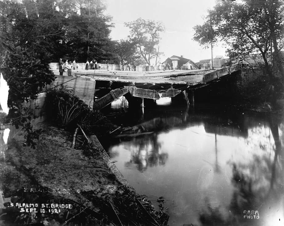

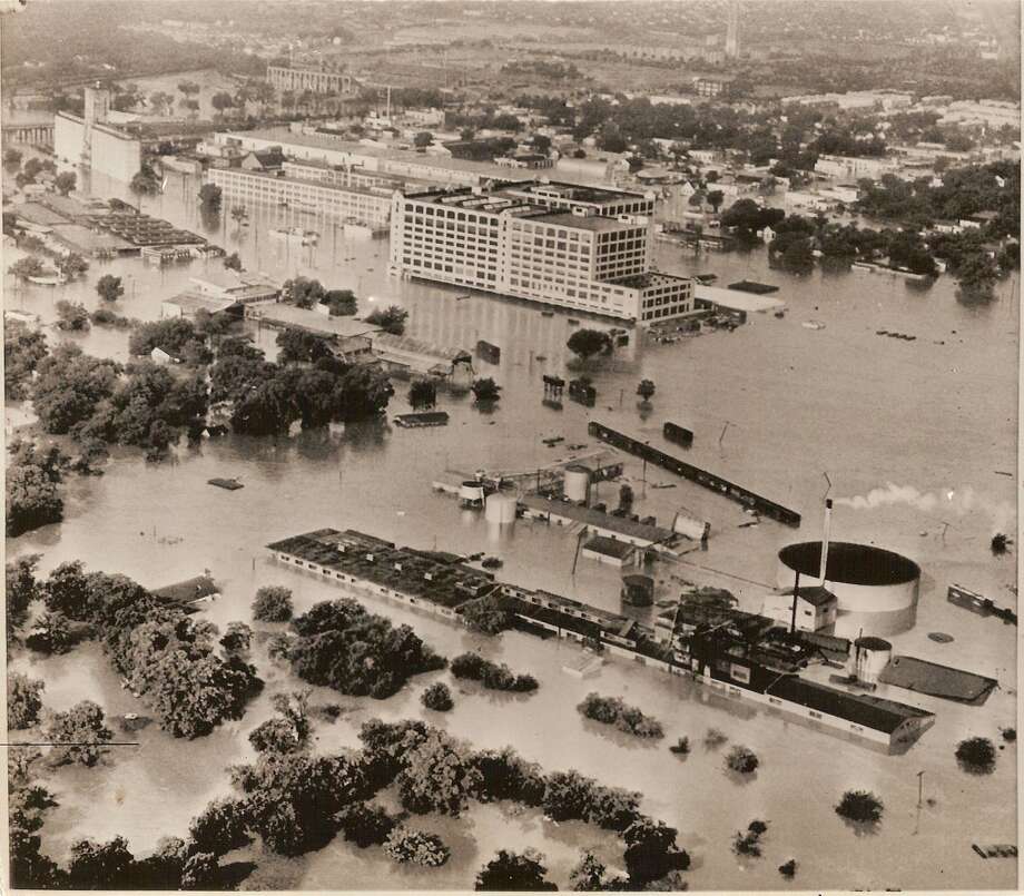

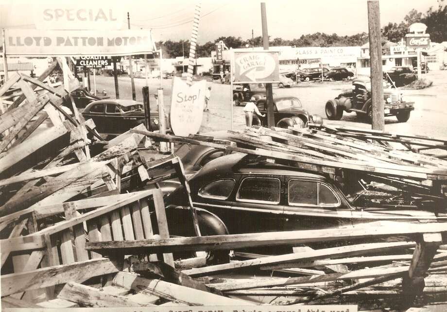
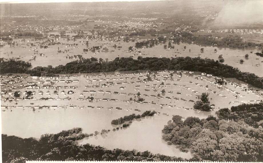

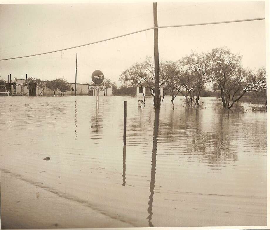


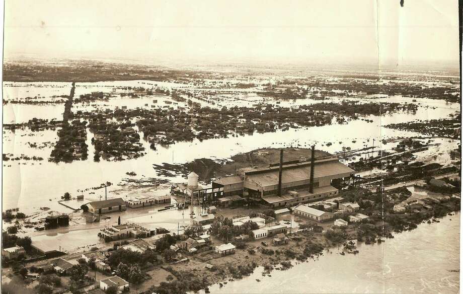
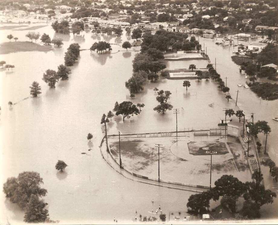
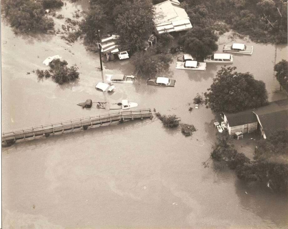


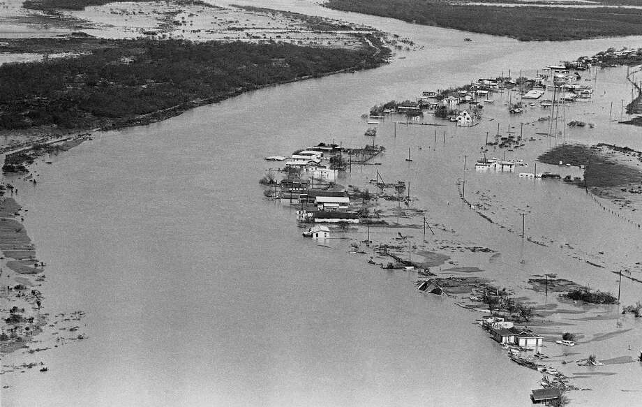


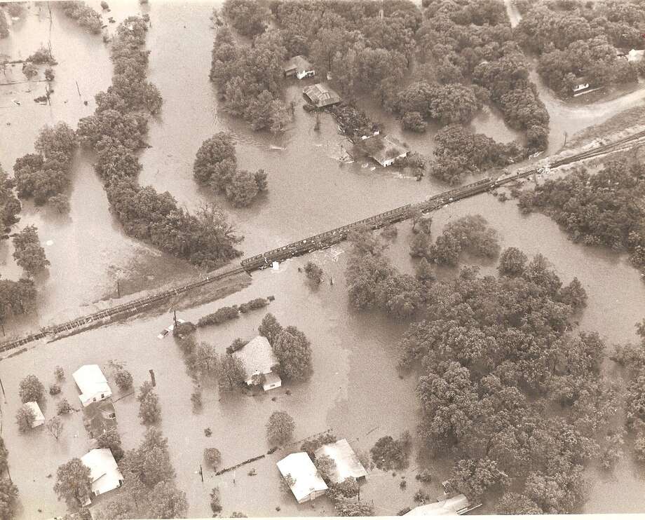


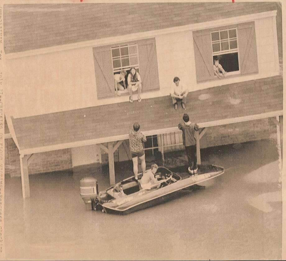


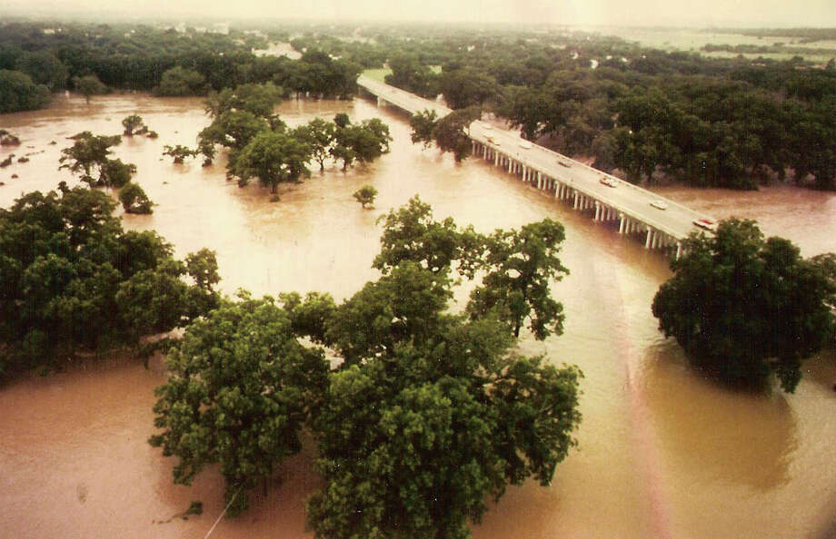


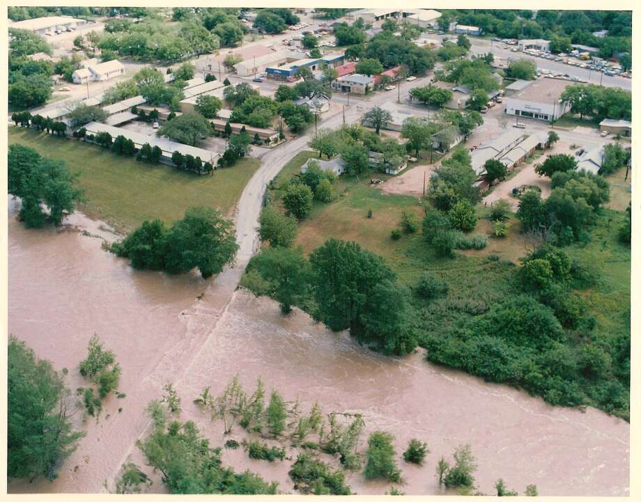


Photo: Texas Game Wardens
Image 1 of / 78
Caption
Close
Image 1 of 78
First responders were kept busy with multiple rescue calls after heavy rain flooded the Llano River in Junction.
First responders were kept busy with multiple rescue calls after heavy rain flooded the Llano River in Junction.
Photo: Texas Game Wardens
RVs reportedly swept away near Concan after heavy rain; flash flood watch extended in S.A. area
1 / 78
Back to Gallery
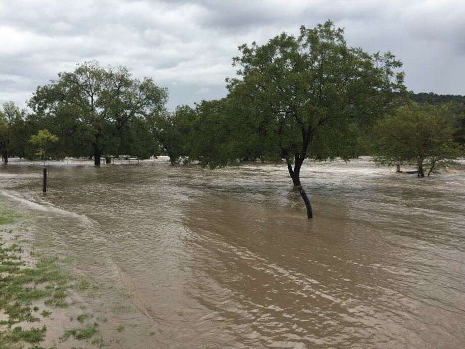
A rainy Sunday resulted in serious flooding issues west of San Antonio, and more rain is in store for Monday, according to the National Weather Service.
Flash flood watches in multiple counties west of Bexar, including Uvalde and Edwards, were extended into Tuesday morning.
In Concan, Texas Game Wardens received several flooding calls, according to a Facebook post.
“At this time there are reports of a number of RVs swept away in the quickly rising waters,” the game wardens wrote in the post.
RELATED: San Antonio office, school openings and closures on Columbus Day 2018
Further north, first responders were kept busy with multiple water rescue calls in Junction, where the Llano River is flooding. Numerous roads and low water crossings in the town were flooded after a canyon collecting water overflowed into the river.
The rain isn’t through yet, either.
Meteorologist Brett Williams said up to 4 inches of rain are expected in the counties west of San Antonio, which is problematic due to oversaturation of rain still in the area.
The storm system, which Williams said was “pretty potent,” will eventually move east into San Antonio. The Alamo City should see rain this afternoon through tonight.
A weak cold front is expected to push the moisture out later this week, and bring the high temperatures down to the 80s starting around Wednesday, Williams said.
Fares Sabawi covers crime in San Antonio and Bexar County for mySA.com. Read more of his stories here. | fsabawi@mysa.com | Twitter: @FaresInSA