- Artists transform hurricane aftermath into hoop-inspired masterpieces at Charlotte exhibit
- NC's cost for Hurricane Helene damage is nearly $60 billion, state says
- State to develop drone program to better respond to disasters like Helene, Florence
- South Carolina residents face deadline to get storm debris out to the curb after Hurricane Helene
- SCDOT to pick up Hurricane Helene debris for a final day in South Carolina
The Latest: Michael becomes a hurricane as it heads to US

The Latest on Tropical Storm Michael (all times local):
2 p.m.
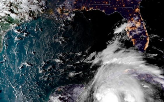
Hurricane Michael is lashing the western tip of Cuba with heavy rainfall and strong winds.
The National Hurricane Center in Miami says Michael’s top sustained winds were around 75 mph (120 kph). The storm was moving north around 7 mph (11 kph).
The storm was centered about 20 miles (30 kilometers) off the western tip of Cuba, and about 145 miles (230 kilometers) east-northeast of Cozumel, Mexico.
Forecasters say Michael will move into very warm waters in the Gulf of Mexico. It could strengthen into a major hurricane with winds topping 111 mph (178 kph) before an expected strike Wednesday on Florida’s Panhandle.
Meanwhile, long-lived Tropical Storm Leslie was expected to gradually strengthen over the Atlantic Ocean but was no threat to the U.S. coastline.
___
11 a.m.
Michael has become a hurricane as the storm gets ready to move into the Gulf of Mexico.
Forecasters at the National Hurricane Center in Miami say Michael will move over very warm waters and could strengthen into a major hurricane with winds topping 111 mph (178 kph) by Tuesday night.
Michael was lashing western Cuba late Monday morning with heavy rains and strong winds.
According to the hurricane center, Michael’s top sustained winds were around 75 mph (120 kph). The storm was moving north around 7 mph (11 kph).
The storm was centered about 50 miles (80 kilometers) off the western tip of Cuba, and about 140 miles (220 kilometers) east-northeast of Cozumel, Mexico.
Michael is forecast to make landfall by midweek in Florida’s Panhandle or Big Bend.
___
10 a.m.
The director of the National Hurricane Center says Florida’s Big Bend could see up to 11 feet (3.35 meters) of storm surge after Tropical Storm Michael strengthens into a hurricane over the warm waters of the Gulf of Mexico.
Ken Graham says the storm’s large size, strong winds and heavy rains could produce a lot of flooding, and the shape of this stretch of coastline makes it particularly vulnerable to storm surge.
Water being forced on shore by the storm could get trapped in estuaries and rivers and pushed inland.
According to the forecast, parts of the Tampa Bay area and the western Florida Panhandle also could see up to 4 feet (1.2 meters) of storm surge.
___
Midnight
A tropical storm that rapidly formed southwest of Cuba could become a dangerous Category 2 hurricane by the time of an expected midweek landfall on the Gulf Coast in the Florida Panhandle.
Florida Gov. Rick Scott has issued an order for a state of emergency for 26 counties to rush preparations in the Florida Panhandle and the Big Bend area, freeing up resources and activating 500 members of the Florida National Guard. Scott says: “This storm will be life-threatening and extremely dangerous.”
Michael became a tropical storm on Sunday with sustained winds of up to 50 mph (85 kph). But it rapidly intensified, and its top winds clocked in at 60 mph (95 kph) by late Sunday evening. The storm is expected to gain hurricane status by Monday night or Tuesday as its core slowly crawls into the Gulf of Mexico, nearing the Florida Panhandle coast around midweek.