- Fake job seekers are flooding the market, thanks to AI
- One set of evacuation orders lifted in Caldwell County after wildfire contained
- 'We gutted every building' | Chimney Rock rebuilding after Hurricane Helene
- 'We gutted every building' | Chimney Rock rebuilding after Hurricane Helene
- Debris from Hurricane Helene provides fuel, complicates containment for spring wildfires
Upgraded to Category 3, Hurricane Michael to hit Carolinas after Florida landfall

(This story was updated at 5:30 p.m. Tuesday.)
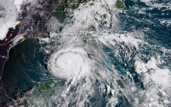
Hurricane Michael was upgraded to a Category 3 hurricane at 4 p.m., Tuesday, and is forecast to make landfall Wednesday before making a predicted trek toward the Carolinas, says the National Hurricane Center.
The storm’s sustained winds were 120 mph as of 4 p.m. Tuesday. A Category 3 Hurricane has winds in the 111 to 129 mph range.
“Additional strengthening is expected, and Michael is forecast to be a major hurricane at landfall,” said an update from the National Hurricane Center. “Weakening is expected after landfall as Michael moves through the southeastern United States.”
The storm is predicted to hit Florida somewhere between Panama City and Tallahassee, reports CNN. It will bring life-threatening flash flooding to the Florida Panhandle and Big Bend region of the state, before moving to Georgia and the Carolinas, says the hurricane center.
Winds of 50 to 70 mph will be felt in parts of the Carolinas as early as 8 p.m. Wednesday, and there is a potential for “dangerous rainfall flooding” and tornadoes, the National Hurricane Center says.
Potential rainfall predictions for the Carolinas remain in the 4 to 6 inch range, says the center. Charlotte and areas to the east can expect that same 4 to 6 inches, while areas north and west of Charlotte could see 2 to 4 inches, according to a 5 p.m. Tuesday expected-rainfall map from the National Weather Service.
The Columbia area is expected to see winds around 40 mph on Thursday, according to the National Weather Service, which reported rainfall totals are forecast between 3.5 and 4 inches.
The National Weather Service said the areas facing the “highest threat for significant impacts,” are expected to be in the Pee Dee region, which is still recovering from the devastation of Hurricane Florence.
Similarly impacted coastal counties in North Carolina have started bracing for yet another round of potential flash floods.
Brunswick County on Tuesday issued a voluntary evacuation notice “for residents in unincorporated areas who live in low-lying or flood-prone areas or storm-damaged homes,” beginning at 8 a.m. Thursday. A state of emergency has been declared, also effective 8 a.m. Thursday. A shelter will open at the same time at West Brunswick High School in Shallotte.
Brunswick County schools will be closed Thursday and Friday, school officials said Tuesday.
An expected 2 to 4 inches of rain in neighboring New Hanover County to the northeast “could cause flooding …. since the ground is still saturated in many areas” from Hurricane Florence, Steven Still, the county’s emergency management director, said in a news release on his agency’s website on Tuesday.
“Peak wind gusts of up to 45 mph could potentially topple already leaning trees and drop hanging limbs, causing further power outages,” Still said in the news alert.
And in nearby Pender County, emergency officials urged residents to prepare for the storm.
“I know you do not want to hear this or even look at this update, but please start making preparations for a tropical event to hit the area around Thursday and Friday,” said a warning issued Monday by the Pender County Emergency Management.
In an interview with the Wilmington Star News, Tom Collins of Pender County Emergency Management warned Hurricane Michael will bring “more damage and more debris,” and shelters may have to be reopened.
“If you haven’t got trees cut around your home, get them cut now if they are leaning,” he told the Star News. “What trees haven’t fallen will probably fall. The river is still pretty high, so it will probably rise back up some as well.”
The Cape Fear Region expects flooding yet again due in part to the ground still being saturated from flooding from Florence last month, National Weather Service meteorologist Kathleen Carroll told the Fayetteville Observer.
“We’ll see some rising … particularly the Cape Fear and the Neuse (rivers) again,” Carroll was quoted telling the Fayetteville Observer. “Minor to moderate flooding is the thinking at this time. Still, it’s not expected to be as bad considering it will be quick hitting.”
While the European model projections have the storm slowing over North Carolina, the American model “quickly ejects the system northeastward and off the coast,” the National Weather Center’s Raleigh office wrote in its 10 p.m. Monday update.
“Our rivers can handle and inch or two of (rainfall) that the GFS is producing, while 6 or more inches of rain that the ECMWF is suggesting would likely result in some renewed river flooding,” the update said.
The storm is moving northward across the eastern Gulf of Mexico at 12 mph.
Hurricane force winds are extending out 45 miles from the center of Hurricane Michael and tropical-storm-force winds (39-73 mph) are being felt 175 miles from the center, says the National Hurricane Center.
“Heavy rainfall from Michael could produce life-threatening flash flooding from the Florida Panhandle and Big Bend region into portions of Georgia and South Carolina,” the forecast discussion said.