- 'A little emotional': Hurricanes equipment manager got seconds in goal, memory to last a lifetime
- WMO retires three hurricane names after devastating 2024 season
- Beryl removed from future hurricane naming lists
- Hurricane names Helene, Milton and Beryl are now retired
- Hurricane Helene's name retired after deadly 2024 impact on US
Flash floods possible in SE Texas on Friday night, Saturday morning

-
Heavy rain is expected in most of southeast Texas on Friday, Dec. 7, 2018.
Heavy rain is expected in most of southeast Texas on Friday, Dec. 7, 2018.
Photo: National Weather Service Houston/Galveston
Heavy rain is expected in most of southeast Texas on Friday, Dec. 7, 2018.
Heavy rain is expected in most of southeast Texas on Friday, Dec. 7, 2018.
Photo: National Weather Service Houston/Galveston
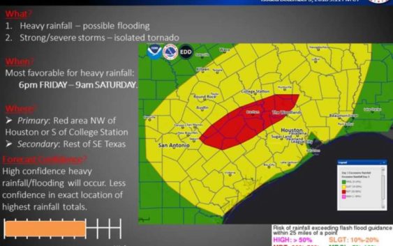
Most of southeast Texas will be under a flash flood watch from Friday afternoon to Saturday morning, according to the National Weather Service Houston/Galveston office.
Heavy rainfall is most possible from 6 p.m. Friday to 9 a.m. Saturday, with the hardest hit areas expected to be northwest of Houston and south of College Station, meteorologists said.
The flash flood watch will be in effect, however, from noon Friday to noon Saturday. Almost all of southeast Texas is encompassed in the watch, including Brazoria, Galveston, Harris, Montgomery, Waller, Fort Bend and Chambers counties.
An incoming cold front and storm system will move west to east over the area, producing the rain. Three to 6 inches of rain are expected over most of the area, with isolated spots receiving as much as 8 to 10 inches, meteorologists said.
The rainfall will clear from west to east on Saturday and should be off the coast by Saturday afternoon.
The National Weather Service has warned that isolated flash flooding could occur around area roadways, underpasses, low lying areas, and small creeks and tributaries.