- Researchers forecast 1 major Gulf hurricane in 2025 season
- NC State forecasts near-average Atlantic hurricane season
- Timeline: Texas cold front brings hail, heavy rainfall risk to major cities
- Evacuation order issued as crews battle wildfire in McDowell County
- NC Gov. Josh Stein outraged by attack on PA governor, focuses on Hurricane Helene recovery
Houston-area under flash flood watch starting at noon today
-
PHOTOS: These streets are most prone to floodingMuch of Southeast Texas will be under a flash flood watch from noon Friday to noon Saturday as severe storms threaten to bring heavy rainfall and flooding to the area.
>>> See the Houston streets that have historically been prone to flooding
PHOTOS: These streets are most prone to floodingMuch of Southeast Texas will be under a flash flood watch from noon Friday to noon Saturday as severe storms threaten to bring heavy rainfall and flooding to
Photo: National Weather Service
PHOTOS: These streets are most prone to flooding
Much of Southeast Texas will be under a flash flood watch from noon Friday to noon Saturday as severe storms threaten to bring heavy rainfall and flooding to the area.
>>> See the Houston streets that have historically been prone to flooding
PHOTOS: These streets are most prone to flooding
Much of Southeast Texas will be under a flash flood watch from noon Friday to noon Saturday as severe storms threaten to bring heavy rainfall and flooding to
Photo: National Weather Service
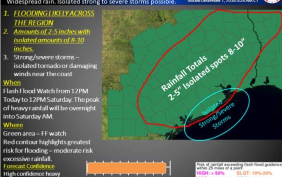
Starting at noon today, much of southeast Texas will be under a flash flood watch as severe storms threaten to bring up to 10 inches of rainfall in some isolated parts of the region.
RELATED: Houstonians warned to stay home Friday night to avoid possible flash floods
Forecasters say the worst of the storm will be overnight into Saturday morning, but the rain is expected to start in a few hours. Houston residents have been urged to stay home if possible. At least 2 to 5 inches is expected with 8 to 10 inches in some areas.
“Wherever that possibly happens, we’re going to see some rises of bayous,” Francisco Sánchez, the county’s deputy emergency management coordinator, told the Houston Chronicle Thursday. “But the biggest threat we have right now is with lower amounts of rain, we’re going to see some high water and dangerous driving conditions.”
There is also a possibility of isolated tornadoes and damaging winds near the coast, the weather service said. The flood watch will expire noon Saturday, with the sun starting to peak out in the Houston area on Sunday.
View the slideshow to see the streets that have historically been the most prone to flooding.
Julian Gill is a digital reporter in Houston. Read him on our breaking news site, Chron.com, and on our subscriber site, houstonchronicle.com. | julian.gill@chron.com | Text CHRON to 77453 to receive breaking news alerts by text message