- Beryl removed from future hurricane naming lists
- Hurricane names Helene, Milton and Beryl are now retired
- Hurricane Helene's name retired after deadly 2024 impact on US
- NC burn ban lifted statewide as rain improves wildfire conditions
- Western NC wildfire risk will 'get worse, not better' Ag Commissioner says, pressing lawmakers for help
NWS: Tornadoes, hail, 60+ mph winds possible as storm cell marches across Texas

-
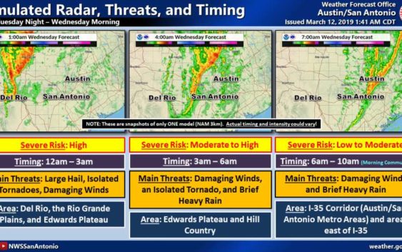
A massive storm cell predicted to roll eastward across Texas tonight could produce tornadoes, hail and winds up to 70 mph, according to meteorologists with the National Weather Service.
A massive storm cell predicted to roll eastward across Texas tonight could produce tornadoes, hail and winds up to 70 mph, according to meteorologists with the National Weather Service.
Photo: National Weather Service
A massive storm cell predicted to roll eastward across Texas tonight could produce tornadoes, hail and winds up to 70 mph, according to meteorologists with the National Weather Service.
A massive storm cell predicted to roll eastward across Texas tonight could produce tornadoes, hail and winds up to 70 mph, according to meteorologists with the National Weather Service.
Photo: National Weather Service
A massive storm cell predicted to roll eastward across Texas tonight could produce tornadoes, hail and winds up to 70 mph, according to meteorologists with the National Weather Service.
The storm’s most severe impacts will hit Del Rio, the Rio Grande Plains and the Edwards Plateau after midnight. The possibility of isolated storms capable of producing tornadoes and large hail will be highest at that time.
According to Monte Oaks, a meteorologist with the National Weather Service, the storm will continue eastward as the night progresses, hitting Bexar County close to sunrise. San Antonio and surrounding areas are on the “eastern periphery” of the threat, he said.
FIND OUT FIRST: Get San Antonio breaking news directly to your inbox
“There will be a much thinner line of severe storms by that time, and the threat will be reduced,” Oaks said.
The storm could, however, produce small hail and frequent lightening. The greatest threat will be high winds of up to 60 mph. Heavy rainfall could reduce visibility for commuters and could cause pooling on roadways.
By 11 a.m., the storm should be east of San Antonio, allowing the city to “start drying out,” Oaks said.
Temperatures could rise close to 80 degrees on Wednesday, but there will be a cooling pattern as the week progresses with lows in the 60s and highs in the 70s.
Text “NEWS” to 77453 for breaking news alerts from mySA.com
Caleb Downs covers crime in San Antonio and Bexar County. Read him on our breaking news site, mySA.com, and on our subscriber site, ExpressNews.com |
cdowns@mysa.com | @calebjdowns