- McDowell County wildfire spreads to 500 acres, evacuation orders in place
- Evacuations in Caldwell County due to wildfire
- Northwest Houston 'ghost neighborhood' caused by repeated flooding to become latest detention basin
- NHL playoffs: Hurricanes open playoffs Easter Sunday afternoon vs. Devils
- 2 wildfires spreading in rugged terrain in western North Carolina
Tornado Warning issued for Harris, Liberty and Chambers County until 1 p.m.
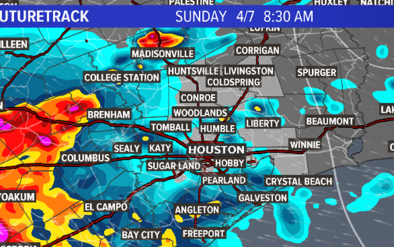
HOUSTON — Today will be a rough day in Houston. Everything from heavy rain to gusty winds, hail and a small, isolated tornado threat will exist most of the day. The Storm Prediction Center has placed our entire area in a ‘Slight Risk’ of severe weather; equating to a 2 out of 5 on a probability scale.
Current southeast Texas watches and warnings
- Severe Thunderstorm Watch for Brazoria, Colorado, Matagorda and Wharton County until 3 p.m.
- Severe Thunderstorm Warning for Chambers, Galveston, Harris, Liberty, Montgomery, Polk, San Jacinto and Walker County until 2:30pm.
- Tornado Warning for San Jacinto and Walker County until 2:15pm.
RELATED: Download the KHOU news app to get severe weather alerts sent to you
The storms will likely start early and end late. This could be an all day event.

Strong to severe thunderstorms have already entered our far northwest counties near Brenham, Columbus, Navasota and racing toward Huntsville.
The latest timing has the storms moving across our western counties this morning, then quickly exiting to the east early this afternoon. Severe threats include hail, wind gusts 40-60 mph, heavy rain, street ponding and the possibility of a brief tornado.
Widespread rain totals of 1-2 inches with localized 3-4 inches likely. The hail threat is real so put the car in the garage or under a carport if available.

KHOU
According to the National Weather Service in Houston, there are currently no plans to issue a flood watch.
The storm system should exit the region around 10 p.m. making way for beautiful weather most of next week.
Houston water has been gradually lowering Lake Houston by 12 inches to prepare for the rain and thunderstorms this weekend. Lake levels will remain one foot lower throughout the week.
Property owners along the shoreline should secure the property.
► Make it easy to keep up-to-date. Download the KHOU News app now.
Have a news tip? Email us or message us on our Facebook page or Twitter feed.