- Here’s how Austin-area leaders are preparing for wildfire threats this summer
- Harris County sues Trump administration, cites threat to hurricane season preparedness
- Prescribed burn in Morrow Mountain aims to prevent future wildfires
- Prescribed burns aim to prevent wildfires in Stanly County
- Prepare for hurricane season with the Town of Leland Hurricane Expo
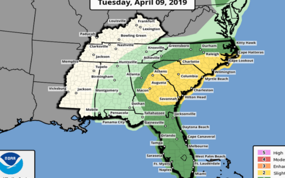
Carolinas may see ‘tater-tot sized hail,’ 40-to-50 mph gusts as more storms move in
More stormy weather in the forecast NC Tuesday, April 9, 2019
Check out the ABC11 weaher forecast for central and eastern NC Tuesday, April 9, 2019 as storms continue to move through the area, hopefully wasing away more of the pollen.
Check out the ABC11 weaher forecast for central and eastern NC Tuesday, April 9, 2019 as storms continue to move through the area, hopefully wasing away more of the pollen.
Another round of unstable weather is expected Tuesday in the Carolinas, including predictions of cloud-to-ground lighting, 40-to-50 mph gusts “and possibly some tater-tot sized hail,” according to the South Carolina State Climate Office.
The worst of the weather will be in the late afternoon, forecasters say.
All parts of the Carolinas could see “clusters of showers,” but the biggest storm potential is spread widely across South Carolina, the National Weather Service out of Raleigh reports.
The S.C. State Climate Office reported Tuesday that the state could get “a whiff of sunshine for lunch,” but scattered thunderstorms would begin to form after 2 pm in the Upstate and start “sweeping east over the state during the afternoon.”
“Expect some isolated cells to be strong to severe, producing lightning, winds gusting to 40-50 mph, and possibly some tater-tot sized hail,” said an email from the S.C. State Climate Office.
In North Carolina, the storms will be at their worst from 11 a.m. to 7 p.m “in a line from near Albemarle to Sanford to Tarboro,” the National Weather Service said.
“Damaging wind gusts and large hail up to the size of quarters” are possible in those regions of N.C., forecasters said.
The National Weather Service in Greenville-Spartanburg , S.C., reports winds may not be a strong as they were during Monday’s storms, but the potential is higher for large hail.
“Cloud to ground lightning” is also possible as the storms move through North Carolina between 4 p.m. and 10 p.m., forecasters say.
“Locally heavy rainfall can be expected, and isolated flash flooding cannot be ruled out,” say NWS forecasters out of Greenville-Spartanburg.
“Additional rounds of thunderstorms, some possibly strong, are expected Friday and again on Sunday.”