- Seven months after Hurricane Helene, Chimney Rock rebuilds with resilience
- Wildfire in New Jersey Pine Barrens expected to grow before it’s contained, officials say
- Storm damage forces recovery efforts in Lancaster, Chester counties
- Evacuation orders lifted as fast-moving New Jersey wildfire burns
- Heartbreak for NC resident as wildfire reduces lifetime home to ashes
Charlotte area and several counties on tornado watch until 5 a.m. Monday

CHARLOTTE, N.C. — The First Warn Storm Team is tracking a strong storm moving through the Carolinas. Around 10:20 p.m., several parts of the Carolinas — including Charlotte, Hickory, Shelby, Greensboro and Chester — were placed on a tornado watch until 5 a.m. Monday.
Just after 8 p.m., the original tornado watch expired for the Charlotte area, but the First Warn Storm Team is keeping an eye on the cold front to the west for gusty thunderstorms.
A severe thunderstorm watch still remains until 10 p.m. for the mountains. There is still a chance for rain and thunderstorms through Sunday evening.
At 7 p.m., Chief Meteorologist Brad Panovich said it was too early to consider Charlotte in the clear. While the Queen City hasn’t been impacted by heavy rain as the storms move through the Carolinas, an impact was still possible.
There’s a front in the West moving through, which Panovich says will determine how hard the Charlotte area will get hit. Even without thunderstorms, high winds are possible for the region.
There have been multiple reports of downed trees, even knocking out power for several, throughout the Carolinas as a result of severe weather.
A tornado warning was issued for Floyd and Patrick until 6:15 p.m. — that has since expired. A severe thunderstorm warning was issued for Chesterfield County until 6:30 p.m. which has since expired.
A tornado warning was issued for Lancaster, Chesterfield and Kershaw counties until 5:30 p.m. and has since expired. A tornado warning was in place for parts of Chesterfield, Kershaw and Lee counties until 5:45 p.m. It has since expired.
A tornado warning was issued for Alexander and Caldwell counties until 4:45 p.m; it has since expired.
Gaston, Iredell, Lincoln, McDowell, Mecklenburg, Rowan, Rutherford and Stanly counties are all under a tornado watch until 8 p.m.
A strong storm moved through Burke County causing the National Weather Service to issue a tornado warning that expired at 4 p.m. There were several reports of trees down along with power lines in Morganton.
A tornado warning had been issued for Rutherford County until 3:45 p.m., with a storm Panovich said was moving close to 50 mph. The warning has since ended.
Along with a lot of wind energy and instability in the atmosphere Sunday, West Virginia mountains and possibly even North Carolina mountains could be getting snow.
Panovich said in the event of tornado warnings in your area, seek shelter and make plans in advance if your home does not have a secured shelter.
Saturday, scattered thunderstorms, showers and tornado warnings caused several roads across the region to flood. Be on the lookout for any road closures on Sunday.

WCNC
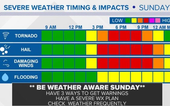
The tornado threat is expected to peak mid to late afternoon Sunday. A lot of the severe weather is expected to come after 2 p.m. Wind and hail threats peak after 3 p.m. to about 9 p.m. Flooding concerns stay elevated through about midnight, though.
“That changing of wind direction is pretty potent energy,” Panovich said. “If we get any breaks in the clouds at any point on Sunday, that will allow for thunderstorms to build into that column of air and you get rotating storms.”
Panovich said those rotating storms don’t always bring tornadoes, although that is a serious threat. The storms could always bring hail, heavy rain and damaging winds to the Charlotte area.
The good news is the weekend won’t be a total washout. Panovich said the showers will be off and on throughout the day on Saturday and Sunday. Any all-day events outside will be impacted, though.
“If you have outdoor plans, the best thing I can tell you at this stage is you’ve got to have a plan,” Panovich said. “If you’ve got an activity where you can wait out a 15 or 20-minute shower, and then get back out, you’re fine.”
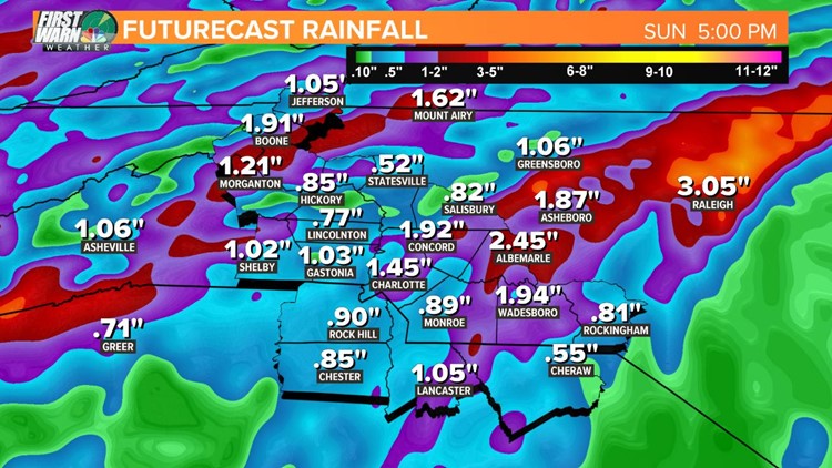
Some areas around Charlotte could see more than 2 inches of rain, while Sprinkle expects the Queen City to get around an inch-and-a-half.
By Sunday evening rainfalls totals could be:
- .85 Hickory
- 1.03 Gastonia
- 1.45 Charlotte
- 1.92 Concord
- 1.94 Wadesboro
- 2.45 Albemarle


WCNC
RELATED: More storms hit Charlotte after severe weather leaves trail of damage
RELATED: Charlotte sees first measurable April snow in 37 years
Less than two weeks into the month and Charlotte’s already seen a little bit of everything from Mother Nature. On April 1, the first measurable snow fell in Charlotte since 1982. That quickly gave way to spring-like temperatures and an explosion of pollen in the Carolinas.
Some people even called it the “pollen apocalypse.” Scott says there’s good news, though. We’re on the downward trend of the pollen season, so if you’re suffering from springtime allergies, try to hang in there for a few more weeks.
