- Recovery continues for western NC nearly three months after Hurricane Helene
- Cast of Scandal reunites to show support for western North Carolina after Hurricane Helene
- Tropical Storm Sara threatens to bring flash floods and mudslides to Central America
- Hurricane-stricken Tampa Bay Rays to play 2025 season at Yankees' spring training field in Tampa
- Utah scores 3 goals in 2 1/2 minutes in 3rd, Vejmelka has 49 saves in 4-1 win over Hurricanes
Risk for flooding, damaging winds come with storm system Friday

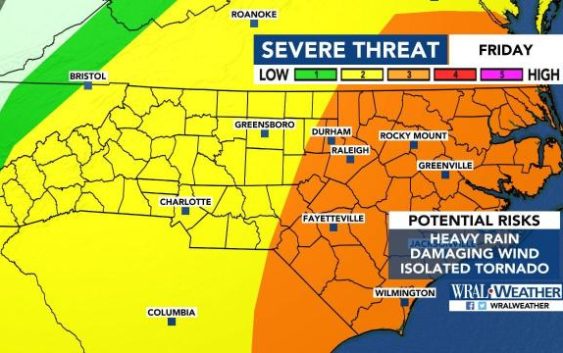
Raleigh, N.C. — Central and eastern North Carolina is at an enhanced risk for severe weather Friday, the U.S. Storm Prediction Center said Wednesday.
WRAL meteorologist Kat Campbell said it’s relatively rare for a higher severe weather alert to be issued three days ahead of a system’s arrival.
The enhanced risk is a level three out of five. North Carolina was at a level two, or a slight risk, when storms brought flooding and a tornado to central parts of the state last weekend.
While the Triangle and eastward are under an enhanced risk for severe weather Friday, western areas of the state are under a slight risk.
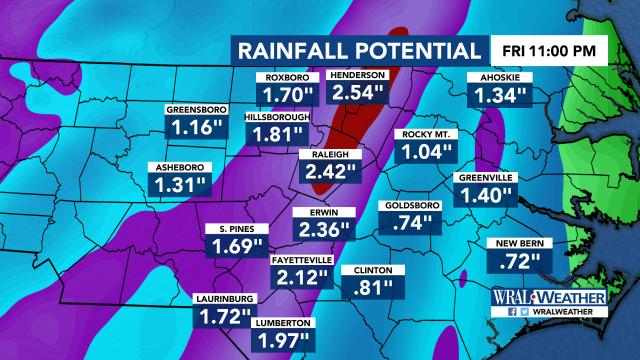
Campbell said her biggest concern is the risk for flooding and wind damage Friday.
While an isolated tornado is possible, “the bigger impacts and the most widespread impacts from this system will be very heavy rainfall and the potential for damaging wind gusts over 60 mph,” she said.
Thursday is expected to be partly cloudy but calm.
Sprinkles move in to the Triangle around 8 a.m. Friday.
Heavier rain and some storms are forecast to arrive around noon, and more organized line of storms will begin moving through the Triangle around 5 p.m.
That storm system is expected to hit Rocky Mount and Fayetteville around 7 p.m. and continue moving east through the night.
Once that system moves out, though, heavy rainfall is still possible.
There’s a 40 percent chance for rain on Saturday. Sunday is expected to be mostly clear.


