- Seven months after Hurricane Helene, Chimney Rock rebuilds with resilience
- Wildfire in New Jersey Pine Barrens expected to grow before it’s contained, officials say
- Storm damage forces recovery efforts in Lancaster, Chester counties
- Evacuation orders lifted as fast-moving New Jersey wildfire burns
- Heartbreak for NC resident as wildfire reduces lifetime home to ashes
Thunderstorms expected in southeast Texas
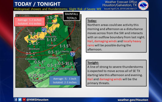
HOUSTON (FOX 26) – A line of strong to severe thunderstorms is expected to move across southeast Texas Thursday night, bringing with it the threat of hail and damaging winds, the National Weather Service says.
Strong to Severe storms will be possible across #SETX today and tonight. Please keep up with the forecast and take necessary precautions. Stay tuned! #Hail #StrongWinds #HeavyRains #houwx #bcswx #glswx #txwx pic.twitter.com/c61AYZud1h
— NWS Houston (@NWSHouston) April 24, 2019
Beginning this afternoon in the Houston area, scattered showers and storms are expected with an otherwise cloudy and breezy day. Tonight and very early Thursday a line of strong to severe storms will move through. Gusty winds and heavy rain are possible.
Storms should move out early tomorrow morning leaving behind much nicer weather through the weekend.
With integrated GPS, the FOX 26 Weather App “Follow Me” option will track you anywhere you go and you can enable weather alerts in your county. Download the app for free ==> bit.ly/2QCOKMm