- Bills introduced a year after state’s largest blaze seek to limit wildfires
- A year after Texas’ largest wildfire, Panhandle residents tugged between hope and anxiety
- Another $500M for Hurricane Helene relief in North Carolina passes key hurdle
- Crews battle wildfire in McDowell County, NC
- Wildfire in McDowell County, NC is 20% contained, officials say
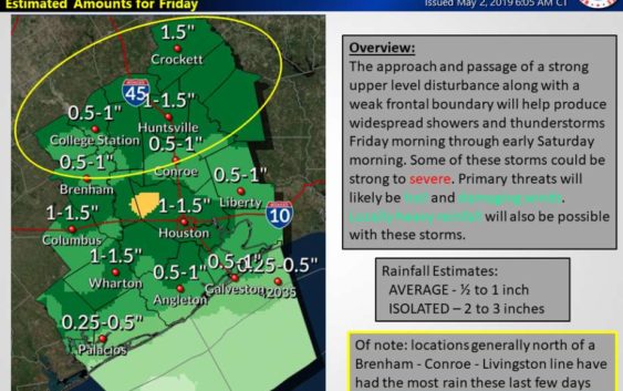
Thunderstorms expected for Houston area, bringing possibility of damaging winds and hail
-
Strong to severe thunderstorms will be possible with this activity, along with hail and damaging winds.
Strong to severe thunderstorms will be possible with this activity, along with hail and damaging winds.
Photo: National Weather Service
Strong to severe thunderstorms will be possible with this activity, along with hail and damaging winds.
Strong to severe thunderstorms will be possible with this activity, along with hail and damaging winds.
Photo: National Weather Service
Expect the start of the weekend to be wet, with the possibility of widespread showers and thunderstorms in Houston area, the National Weather Service reported.
A strong upper level disturbance and a weak cold front are moving in Friday, bringing the potential of strong to severe thunderstorms with hail and damaging winds, according to the NWS.
Locally heavy rainfall is also likely, especially for locations across northern Southeast Texas that have already seen the most rain the last few days, the NWS reported.
Current projections are for 1/2 to 1 inch rainfall totals on average with isolated amounts from 2 to 3 inches possible.
Storms are expected to clear by Saturday night.
While high temperatures are expected to stay in the low- to mid- 80s, the low will gradually decline over the next three days, dropping from 74 Thursday evening to 70 Friday night and 69 late Saturday.
Marcy de Luna is a digital reporter. You can follow her on Twitter @MarcydeLuna and Facebook @MarcydeLuna. Read her stories on our breaking news site, Chron.com, and on our subscriber site, HoustonChronicle.com. | Marcy.deLuna@chron.com | Text CHRON to 77453 to receive breaking news alerts by text message