- Fake job seekers are flooding the market, thanks to AI
- One set of evacuation orders lifted in Caldwell County after wildfire contained
- 'We gutted every building' | Chimney Rock rebuilding after Hurricane Helene
- 'We gutted every building' | Chimney Rock rebuilding after Hurricane Helene
- Debris from Hurricane Helene provides fuel, complicates containment for spring wildfires
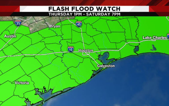
WEATHER ALERT: Flash flood watch issued until Saturday night
Another round of powerful storms is expected in the region Thursday, and that will be followed by several waves of heavy rain through Saturday. Flooding is possible in some locations.
Here’s what you need to know.
Right now
Flash flood watch – All of Southeast Texas from 1 p.m. Thursday to 7 p.m. Saturday.
Flood warning – Some rivers in southeast Texas, including the Trinity River, Brazos River, Navasota River, San Bernard River and San Jacinto River.
Read more on the weather alerts page.
As of 7:20 a.m. Thursday, Houston TranStar reported only one high water locations:
- SH-99 Lanier Pkwy – North Eastbound At Townsen Blvd/Imperial Promenande, 2 Frontage Road Lanes
Officials in Sugar Land said Thursday that all flood waters have receded and streets are passable, but they urged residents and drivers to remain vigilant. Real-time information about streets in Sugar Land can be found at its.sugarlandtx.gov or by calling 311.
Remember, it is never safe to drive through flood waters.
Several school districts and some colleges have either canceled or modified their schedules Thursday. Read more in the full story about closings and delays.
What’s happened
The nearly 10 inches of rain that fell in Kingwood and Sugar Land on Tuesday left behind significant damage in some neighborhoods.
A portion of Hamblem Road in Kingwood was washed away after heavy rains caused a water main break in the area. Officials said it could take several weeks to repair.
PHOTOS: Highwater, flooding across Houston area
Fort Bend County officials issued a disaster declaration after the deluge that flooded much of the Sugar Land area on Tuesday evening.
The Red Cross has opened shelters in Kingwood, New Caney and Needville.
The forecast
Another round of powerful storms is forecast Thursday, before a front stalls across Southeast Texas and is the focus of several waves of heavy rain through Saturday.
Between 5 and 8 inches of rain is forecast for much of the region, but some places could receive as much as 12 inches of rain.
The bulk of the rain shifts east of the region by Mother’s Day.
Get the latest forecast on the weather page.
Copyright 2019 by KPRC Click2Houston – All rights reserved.