- Fake job seekers are flooding the market, thanks to AI
- One set of evacuation orders lifted in Caldwell County after wildfire contained
- 'We gutted every building' | Chimney Rock rebuilding after Hurricane Helene
- 'We gutted every building' | Chimney Rock rebuilding after Hurricane Helene
- Debris from Hurricane Helene provides fuel, complicates containment for spring wildfires
FORECAST: Potential for severe weather tonight
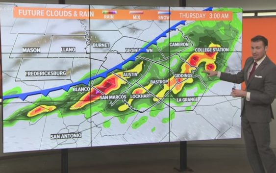
AUSTIN, Texas — Weather Outlook
A line of severe thunderstorms is forming out in west Texas this afternoon. The line will gradually make it’s way to the Austin metro but will lose some intensity as it does so. We’ll go for a 60% chance of showers and thunderstorms as the broken line makes it’s way to Central Texas, some storms could still be severe with large hail and damaging winds being the main threat. We begin to dry out and warm up beginning Saturday as high pressure begins to build over Texas.
DETAILED FORECAST:
TONIGHT:
Scattered showers and thunderstorms. A 60% chance of rain, a few storms could be strong with damaging winds and large hail. A strong southeast wind at 10 to 15 shifting to a northeast wind at 5 to 10 mph.
LOW: 72°
TOMORROW:
Mostly cloudy and cooler with a 40% chance of showers throughout the day. Northeast winds from 5 to 10 mph.
HIGH: 86°
FRIDAY:
Mostly cloudy with a 20% chance of a lingering shower in the morning. Winds shifting from the northeast to the east/southeast 5 to 10 mph.
HIGH: 86°
RELATED: Allergy Report
Stay with KVUE on social media and download the KVUE News app so you can stay ahead of the storm. kvue.com/app