- National memorial to honor NC firefighter who died on duty during Hurricane Helene
- Gov. Josh Stein extends State of Emergency for western NC wildfires
- Governor Stein extends state of emergency for NC wildfire threat
- Governor Stein extends emergency in 34 NC counties amid wildfire threat
- Texans can buy emergency preparation supplies tax-free April 26-28 ahead of severe weather season
Tornadoes, damaging winds possible in Raleigh, Sandhills areas Wednesday
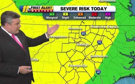
RALEIGH (WTVD) — ABC11 is in First Alert Mode as 31 million people are at a slight risk for severe weather on Wednesday. A number of those people are in the Triangle and the Sandhills.
Over 1/3 of the US population under a risk for severe weather today. 31 million are under a slight (category 2) risk with the biggest threat from damaging winds. That includes our entire viewing area. Please be #weatheraware today! #ncwx pic.twitter.com/92gCH465Bu
— Don Schwenneker (@BigweatherABC11) June 5, 2019
Residents in central North Carolina could see tornadoes, hail and damaging winds.
Don “Big Weather” Schwenneker said we’ll start off sunny but showers and thunderstorms will push in during the afternoon.
Slight (Category 2 of 5) Risk for severe storms for later today. Though any storm can up a tornado, the biggest threats will come from damaging winds and possibly some hail. #ncw pic.twitter.com/rrtzEwNpxz
— Don Schwenneker (@BigweatherABC11) June 5, 2019
He said storms could linger into the evening. Overnight, temperatures will fall into the 70s.
Temps will climb back into the 90s on Thursday, with a mix of sun and clouds.
Residents are encouraged to be prepared as several tornadoes have been reported in North Carolina within the last few weeks.
Check the radar anytime with the free AccuWeather app for iPhone and Android today!
Copyright © 2019 WTVD-TV. All Rights Reserved.