- Montgomery County residents unite to weather freezing temperatures and rebuild after tornado damage
- New charge filed against ex-security guard accused of using hidden cameras to take videos of girls at The Woodlands Mall, Hurricane Harbor
- Mecklenburg County residents can attend sessions this week to apply for Hurricane Helene disaster relief
- Steiner Ranch deploys goats for wildfire prevention efforts
- Goats graze greenbelt to reduce wildfire risk in Steiner Ranch
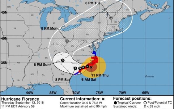
11 p.m. update: Florence now 'life-threatening' to NC coast
Hurricane hits coastal regions with storm surge and hurricane-force winds
11 p.m. update: Florence now ‘life-threatening’ to NC coast
Hurricane Florence has now struck the state’s coast, bringing howling winds and storm surges, according to an 11 p.m. briefing by the National Hurricane Center.
“Life-threatening storm surge and hurricane-force winds occurring along the North Carolina coast,” the briefing said. “Threat of freshwater flooding will increase over the next several days.”
The storm’s eye was just 50 miles southeast of Wilmington at 11 p.m., with Florence’s winds having weakened slightly to 90 mph, downgrading the hurricane to a Category 1 storm as it begins roaring into the Wilmington region.
But officials cautioned that the wind was among the least of the concerns from Florence, which is expected to stall over the Wilmington area, dumping as much as 30 to 40 inches of rain in some places.
Storm surges of up to 10 feet and winds of up to 80 mph have been recorded at monitoring stations along the coast, the advisory said.
As the storm continues toward Southeastern North Carolina, it will bring life-threatening storm surges, flooding and dangerous waves to the coast, the briefing said.
“The deepest water will occur along the immediate coast in areas of onshore winds, where the surge will be accompanied by large and destructive waves. Surge-related flooding can vary greatly over short distances,” the advisory said.
Once it makes landfall Friday, Florence is expected to stall, drenching the region with 20 to 30 inches and as much as 40 inches in isolated areas.
“This rainfall will produce catastrophic flash flooding and prolonged significant river flooding,” the briefing said.
>>READ MORE: Click here for complete coverage of Hurricane Florence.
8 p.m. update: Florence starts hitting N.C. with hurricane winds
Hurricane Florence has officially hit the North Carolina coast, according to an 8 p.m. briefing by the National Hurricane Center.
“Sustained hurricane-force winds occurring along the North Carolina coast,” the briefing said.
Observation stations at the coast recorded wind speeds of more than 80 mph, the advisory said.
“Little change in strength is expected before the eye of Florence reaches the coast, with slow weakening expected after the center moves inland or meanders near the coast,” the advisory said.
The storm remained a Category 2 hurricane with maximum sustained winds of 100 mph. It was located 85 miles from Wilmington at 8 p.m. Thursday and its eye was expected to make landfall Friday, the advisory said.
The storm has slowed considerably and was moving at 5 mph toward the Port City.
5 p.m. update: Florence slows; within 100 miles of Wilmington
Hurricane Florence has slowed as it approaches Wilmington, now marching at 5 mph as it continues to aim its center at Wilmington, according to a 5 p.m. briefing by the National Hurricane Center.
The storm was about 100 miles southeast of Wilmington and had maximum sustained winds of 100 mph, which is slightly weaker than earlier Thursday, the briefing said.
“A slow westward to west-southwestward motion is expected Friday night and Saturday. On the forecast track, the center of Florence will approach the coasts of North and South Carolina later tonight, then move near or over the coast of southern North Carolina and northeastern South Carolina in the hurricane warning area on Friday,” the briefing said.
2 p.m. update: Florence continues march to Wilmington
Hurricane Florence’s eye was slightly more than 100 miles from Wilmington, according to a 2 p.m. briefing by the National Hurricane Center.
The Category 2 storm was churning 110 miles southeast of Wilmington with maximum sustained winds of 105 mph. It was moving 10 mph toward the Port City, the advisory said.
“This general motion, accompanied by a gradual decrease in forward speed, is expected through today. A turn toward the west-northwest and west at an even slower forward speed is expected by tonight and continuing into Friday, and a slow west-southwestward motion is forecast Friday night and Saturday,” the bulletin said.
Florence is expected to make landfall about 8 a.m. Friday, then stall over the Wilmington region, dumping up to 35 inches of rain and prompting worry of “extreme” flash flooding.
The storm’s outer bands have reached the Wilmington region, prompting flooding in coastal communities from the hurricane’s high storm surges, which forecasters said would be up to 13 feet high.
“The combination of a dangerous storm surge and the tide will cause normally dry areas near the coast to be flooded by rising waters moving inland from the shoreline,” according to the National Hurricane Center.
11 a.m. update: Florence weakens slightly
Hurricane Florence’s sustained wind speeds have lessened slightly to 105 mph, but the storm is already bringing surges and tropical storm winds to the North Carolina shore, the National Hurricane Center said in an 11 a.m. briefing.
Florence is lashing the state with “heavy rainbands with tropical-storm-force winds spreading across the Outer Banks and Coastal Southeastern North Carolina,” the briefing said. “Life-threatening storm surge and rainfall expected.”
The storm’s eye was about 145 miles southeast of Wilmington as of 11 a.m., the briefing said. Its maximum sustained winds dropped slightly from 110 mph earlier Thursday to 105 mph, but the storm remains a Category 2 hurricane that is expected to cause widespread catastrophic damage.
“This storm will bring destruction to North Carolina,” Gov. Roy Cooper said Thursday morning.
The National Hurricane Center said the storm’s strength should continue through Thursday.
“Little change in strength is expected before the center reaches the coast, with weakening expected after the center moves inland,” the briefing said.
The briefing said Florence “is a large hurricane” with hurricane-force winds extending 80 miles from its center and tropical storm-force winds extending 195 miles from the eye of the storm.
The storm is also predicted to bring historic rainfall of up to 35 inches to the Wilmington region.
“This rainfall will produce catastrophic flash flooding and prolonged significant river flooding,” the briefing said.
The first large power outage in the Wilmington area also occurred Thursday morning, with the Duke outage map showing nearly 1,400 customers in the Acme-Delco area of Columbus County and northwest Brunswick County without power.
8 a.m. update: Record-shattering rain
The outer bands of Hurricane Florence have reached Wilmington, with weather officials saying the storm will bring unprecedented rain to the region.
“It has moved in,” said Jordan Baker, a meteorologist with the National Weather Service Office in Wilmington. “We’re about to be in the thick of it.”
As of Thursday morning, forecast models showed the storm bringing more rain than originally thought — officials now predict 35 inches of rain will fall in a two-day period as Florence, now a Category 2 storm with 110 mph sustained winds, will stall over Wilmington after making landfall early Friday morning.
The storm’s center was about 170 miles southeast of Wilmington at 8 a.m. Thursday, according to a National Hurricane Center briefing.
To put the rain in perspective, Wilmington’s three-day rainfall record was 19.66 inches set in 2010, said Jordan Baker, a meteorologist with the NWS Wilmington office.
“It will be historic,” Baker said of the rain from Florence. “It’s something we haven’t seen … ever.”
Baker said the rain will bring damaging flash flooding to all areas of the Wilmington region, not just low-lying areas that are particularly vulnerable.
“It doesn’t matter where you are,” he said. “It will probably fall faster than it can leave. Flash flooding is going to be a big issue soon — certainly catastrophic.
7 a.m. update: Florence weakens, but still a dangerous storm
Hurricane Florence has weakened somewhat early Thursday as its outer bands approach the North Carolina coast, but weather officials cautioned that the storm will still bring life-threatening conditions.
After maintaining Category 4 or 3 status most of Wednesday, Florence was a Category 2 storm with maximum sustained winds of 110 mph churning about 205 miles southeast of Wilmington, according to a 5 a.m. briefing by the National Hurricane Center.
That said, the storm is still expected to stall once it hits the Wilmington coast, with weather officials early Thursday raising the expected total rainfall for Wilmington to 35 inches — weather officials had predicted 30 inches for Wilmington in briefings released Wednesday.
“Since the track is slower and the storm will reside in the area for a longer period of time rainfall amounts are expected to be extreme,” Reid Hawkins, science officer for the National Weather Service office in Wilmington, said in a statement. “Significant river flooding is expected as a result of excessive rainfall across area hydrologic basins.”
And the storm is still expected to bring catastrophic winds, rain, storm surges and flooding, the National Hurricane Center briefing said.
“This is a life-threatening situation. Persons located within these areas should take all necessary actions to protect life and property from rising water and the potential for other dangerous conditions,” the hurricane center briefing said. “The combination of a dangerous storm surge and the tide will cause normally dry areas near the coast to be flooded by rising waters moving inland from the shoreline.”
Numerous communities throughout the region have issued either mandatory or voluntary evacuation orders. On Thursday morning, South 17th Street, usually teeming with commuter traffic by 6:30 a.m., was nearly devoid of cars.
New Hanover County officials said Thursday morning that it could accept more residents seeking shelter at Trask Middle School, Eaton Elementary School, Codington Elementary School, the Johnson Pre-K Center and Noble Middle School. On Wednesday, officials said some of those shelters were at capacity, but in a statement early Thursday, county officials said they were “able to mobilize additional resources to accommodate the need for shelter space.”
Reporter Tim Buckland can be reached at 910-343-2217 or Tim.Buckland@StarNewsOnline.com.