- Here’s how Austin-area leaders are preparing for wildfire threats this summer
- Harris County sues Trump administration, cites threat to hurricane season preparedness
- Prescribed burn in Morrow Mountain aims to prevent future wildfires
- Prescribed burns aim to prevent wildfires in Stanly County
- Prepare for hurricane season with the Town of Leland Hurricane Expo
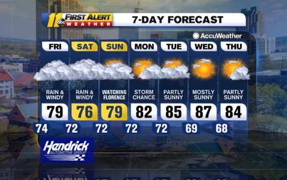
Watching Florence

major impacts on the local weather and across a large part of North
and South Carolina. The size of Florence has grown quite large with
tropical storm-force winds cover a diameter of more than 450 miles.
This immense storm is slowing and expected to just crawl once it
reaches the southeast coast of North Carolina near Wilmington Friday
morning. It will move west-southwest or southwest for a time and then
slowly west over the weekend. This is a long-duration storm in both
hours of wind and tidal surge problems as well as rainfall.
Showers will increase overnight along with a freshening of the wind in
the Triangle. Conditions will worsen during the day Friday with wind
and rainfall increasing in intensity. Windy to very windy conditions
are likely later in the day into Saturday and heavy rain will fall
through Saturday and possibly even Sunday.
Winds will increase to tropical storm-force with gusts for a time in
the 50- to 55-mph range, though higher gusts are possible especially
east and south of the Triangle. This wind can cause damage by itself,
compounded by the increasingly wet ground, making it easier for trees
to be toppled.
Total rainfall through the entire event, which is through Monday, is
most likely to be 6-10 inches with an AccuWeather Local StormMax of
12-16 inches across the area. Major flooding is likely and, even in
areas that do not tend to flood, flooding could become a problem.
Between flash flooding and longer-duration river flooding, some areas
may be cut off from the outside world at least for a short period of
time, perhaps days in the worst-hit areas. Washed out and flooded
roadways could isolate some communities. If you are told to evacuate,
please heed the officials in charge. It is in your best interest to
leave before you are no longer able to leave.
Stay safe!
-Brittany Bell
Check the radar anytime with the free AccuWeather app for iPhone and Android today!
(Copyright ©2018 WTVD-TV. All Rights Reserved.)