- Western NC wildfire risk will 'get worse, not better' Ag Commissioner says, pressing lawmakers for help
- Watering trees is a must to protect them from severe weather and drought
- At least 4 dead, hundreds rescued after deadly floods ravage South Texas
- Today on Texas Standard: Deadly floods swamp South Texas, shatter records
- North Carolina radio station was a critical lifeline after Hurricane Helene. Then it became the voice of recovery.
LIVE VIDEO: Hurricane Florence coverage tracks path through North Carolina

The slow-moving system is moving northwest at 6 mph, drenching coastal areas with heavy rain.
ABC11 is providing live, nonstop coverage of Hurricane Florence. For regular programming go to 11.2.
Click here for how to find 11.2
Scroll down for latest updates
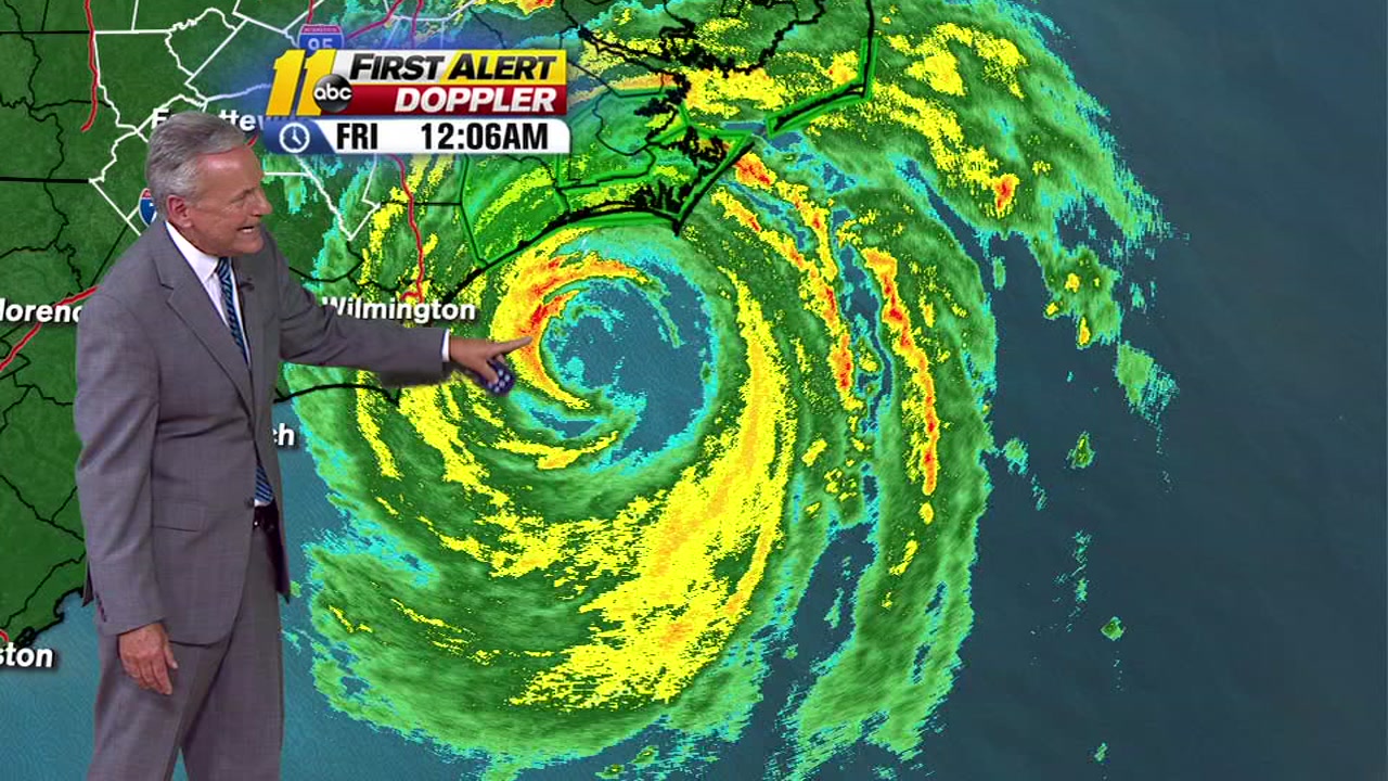
LIVE RADAR: Outer bands of Hurricane Florence have reached the Triangle
POWER OUTAGES: Thousands are already without power. Stay updated on outages here.
MORE: Full coverage of Hurricane Florence
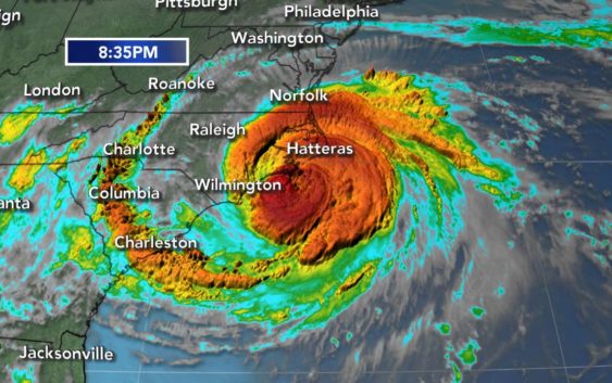
Outer bands from the hurricane are now lashing land, at least a full day before the National Hurricane Center expects the slow-moving storm’s eye to blow ashore around the North Carolina-South Carolina line.
LATEST RADAR IMAGE:
Forecasters said that given the storm’s size and sluggish track, it could cause epic damage akin to what the Houston area saw during Hurricane Harvey just over a year ago, with floodwaters swamping homes and businesses and washing over industrial waste sites and hog-manure ponds.
The state has opened more than 120 shelters for Florence evacuees.
The storm’s eye continued to show deterioration; however, the threat of rainfall has not diminished for the Triangle-area. (Expected impact for the Triangle here.)
11 p.m.
Florence has been downgraded to a Category 1 hurricane with top sustained winds of 90 mph. Florence is now lashing the North Carolina coast with hurricane -force winds and a life-threatening storm surge.
The National Hurricane Center said Thursday night that the threat of freshwater flooding will increase in coming hours and days from the storm’s heavy rains.
The storm’s eye was about 50 miles south of Morehead, City, and Florence is moving to the northwest at 6 mph.
Forecasters said the center of Florence is expected to move inland between Friday and Saturday.
9:30 p.m.
Utility crews from as far away as California and Canada have been brought to North Carolina to respond to what could be millions of power outages following Hurricane Florence. As the crews gathered near the State Capitol in Raleigh on Thursday, dozens of trucks clogged the parking lots and lined the streets. Cherry pickers jutted into the darkening sky, and rusty utility pole drills stood at the ready.
With Duke Energy expecting up to 3 million power outages for its 4 million customers, power companies will need an extra hand.
8:30 p.m.
The North Carolina Division of Adult Correction and Juvenile Justice has evacuated several thousand adult and juvenile offenders and staff from facilities threatened by the effects of Hurricane Florence. More than 3,000 offenders have been relocated from facilities in the path of Hurricane Florence. Four county jails have also been evacuated with more than 300 offenders housed temporarily in state facilities.
7:30 p.m.
Forecasters said conditions will only get more lethal as the storm smashes ashore early Friday near the North Carolina-South Carolina line and crawls slowly inland. Its surge could cover all but a sliver of the Carolina coast under as much as 11 feet of ocean water, and days of downpours could unload more than 3 feet of rain, touching off severe flooding.
6:30 p.m.
Virginia Gov. Ralph Northam says residents should shelter in place and stay off the roads as Hurricane Florence starts to come ashore in the Carolinas and its effects make their way north.
5:30 p.m.
Hurricane Florence is gradually slowing and weakening as its eye nears land. As of 5 p.m. Thursday, the Category 2 storm was centered about 100 miles east-southeast of Wilmington, North Carolina, and about 155 miles east of Myrtle Beach, South Carolina. Its forward movement was 5 mph and top sustained winds stayed at 100 mph.
5 p.m.
Florence remained a Category 2 hurricane with 100 mph maximum winds. It’s still expected to make landfall along the North Carolina coast Friday.
3:15 p.m.
South Carolina officials say more than 400,000 people have evacuated the state’s coast and more than 4,000 people have taken refuge in shelters as Hurricane Florence approaches.
2:45 p.m.
The outer bands of Hurricane Florence have begun to impact the coast of North Carolina.
Officials say Hurricane Florence could bring not only flooding but also landslides to South Carolina. The National Weather Service is forecasting “significant” river flooding, especially in the northeastern portion of the state. That same area experienced dangerous flooding after Hurricane Matthew in 2016.
Gov. Henry McMaster told reporters Thursday that up to 7 inches (18 centimeters) of rain in the state’s northwestern mountains could mean landslides and dangerous conditions. McMaster has ordered evacuations along much of the state’s coast. He warned residents to be prepared to be without electricity “for a long time” in the storm’s aftermath.
11:50 a.m.
A private weather-forecasting firm is estimating that Hurricane Florence will cause $50 billion to $60 billion in economic damages.
Accuweather founder and President Joel Myers said in a news release Thursday that much of that will stem from flooding, with coastal damage as the second-biggest factors. Winds come in third.
11:20 p.m.
Far out in the Atlantic, Joyce strengthened into a tropical storm on Thursday evening with top sustained winds of 40 mph. The center says that storm is about 1,040 miles west-southwest of the Azores and no coastal watches or warnings are in effect. Elsewhere, Tropical Storm Helene is forecast to pass near the Azores on Saturday, and Tropical Storm Isaac is moving west across the eastern Caribbean.
11 a.m.
Florence remains a category 2 storm; however, winds dropped to 105 mph.
Even though the eye of the storm may not come very close to central North Carolina, the winds field and heavy rainfall will.
10 a.m.
During a news conference Thursday morning, Gov. Roy Cooper reminded North Carolinians about the seriousness of the storm.
“My message today: Don’t relax. Don’t get complacent. Stay on guard. This is a powerful storm that can kill. Today, the threat becomes a reality.”
Officials reminded residents to refrain from driving through standing water and using generators inside of their home.
Wells Fargo also announced it was closing 47 branches in North Carolina on Thursday.
9:30 a.m.
During a news conference, officials with Federal Emergency Management Agency urged people to remain alert.
“Just because the wind speeds came down and the intensity of this storm came down to a Cat. 2, please do not let your guard down,” a FEMA official said while warning that the storm surge would still be strong.
Around 9:30 a.m Thursday, the Category 2 storm was about 170 miles east-southeast of Wilmington 220 miles east of Myrtle Beach, South Carolina.
5 a.m.
The storm could make landfall around 2 a.m. Friday anywhere from Cape Lookout to Wilmington.
When it does make landfall it is expected to be a Category 1 with winds of 105 mph.
It will then turn into a Tropical Storm on Saturday as it heads south.
4:30 a.m.
A Flash Flood Watch was issued for Chatham, Davidson, Edgecombe, Franklin, Nash, Randolph, Wake, Wilson, Anson, Harnett, Hoke, Johnston, Montgomery, Moore, Richmond, Scotland, and Stanly counties.
Many parts of the Triangle could see up to 15 inches of rain.
(Copyright ©2018 ABC11-WTVD-TV/DT. All Rights Reserved – The Associated Press contributed to this report.)
