- Fake job seekers are flooding the market, thanks to AI
- One set of evacuation orders lifted in Caldwell County after wildfire contained
- 'We gutted every building' | Chimney Rock rebuilding after Hurricane Helene
- 'We gutted every building' | Chimney Rock rebuilding after Hurricane Helene
- Debris from Hurricane Helene provides fuel, complicates containment for spring wildfires
Stay alert: Risk for severe weather increases across central NC
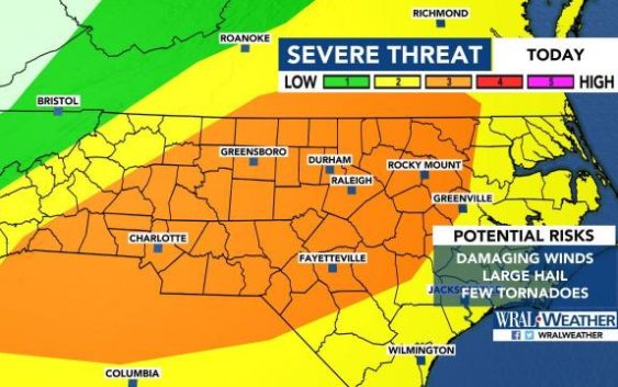
Raleigh, N.C. — Damaging winds, large hail and isolated tornadoes are possible Wednesday as a round of severe weather moves through our area.
“Stay weather alert,” said WRAL meteorologist Aimee Wilmoth of the level 3 risk for severe weather that stretches across the entire viewing area.
According to Wilmoth, the timing of the storms will be late afternoon through the evening commute.
The severe weather will be the result of a front that brought storms across the mid-Mississippi Valley, the lower Mississippi Valley and the Southern Plains on Wednesday.
Subscribe to get WRAL weather alerts to your device
The Triangle is at a level 3 out of 5 for the possibility of severe storms, Wilmoth said.
“This is pretty serious, and it’s really our entire viewing area,” WRAL meteorologist Elizabeth Gardner said.
While Thursday will start quiet but muggy, storms are expected to move in around 3 p.m.
Gusts could reach 40 to 60 mph, and hail could be the size of quarters or larger. Temperatures will reach 87 degrees by lunchtime and 92 degrees in the afternoon.

There’s only a 10% chance for rain Thursday morning. That increases to 40% in the afternoon and 50% in the evening.
Once the front moves out of the area, though, things will be quiet again.
Friday looks like a good day to go to the pool or a lake, as the official start of summer will have highs in the mid-to-upper 80s and mostly clear skies.
June 21 is known as the longest day of the year. The sun will rise in Raleigh around 6 a.m., and daylight will extend past 8:30 p.m.
