Live Blog: State of emergency in Louisiana with hurricane watch in effect

NEW ORLEANS — Here is a live blog with the latest updates on the tropical system in the Gulf of Mexico.
Thursday, July 11:
– 3:47 a.m.
The National Hurricane Center’s latest 4 a.m. advisory says Potential Tropical Cyclone Two is not a depression yet, but is “expected to be one soon.”
The system is currently sitting about 125 miles south southeast of the mouth of the Mississippi River, with maximum sustained winds of 30 mph. Click here for the latest forecast.
– 3:30 a.m.
Nearly 13,500 people lost power Wednesday night around the Ponchatoula area, according to Entergy Louisiana’s online outage map.
According to the online map, the entirety of Ponchatoula and much of the surrounding area south of I-12 all lost power at once at 12:41 a.m. 13,474 customers were affected as of 3:30 a.m.
“Due to the thunderstorms along with the high winds that have and continue to move through the area we are experiencing numerous outages,” Entergy said online. More details here.
-3:12 a.m.
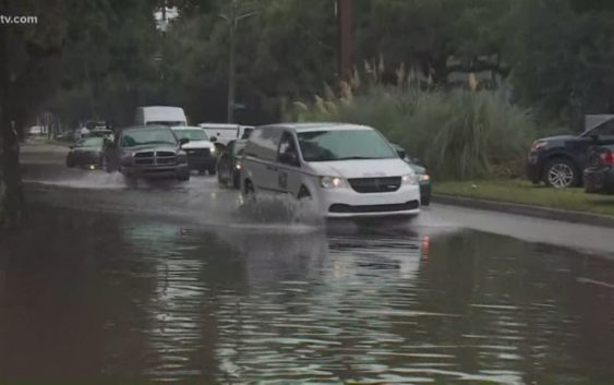
A potential tropical storm brewing in the Gulf of Mexico presents twin troubles for parts of southeast Louisiana — the possibility that a high Mississippi River will be lapping at the tops of levees this weekend, and a danger of flash floods like the one that unexpectedly walloped New Orleans on Wednesday.
PHOTOS: Waterspouts, flooding in New Orleans
As much as 8 inches of rain was dumped in parts of metro New Orleans in a three-hour span, ahead of the Gulf of Mexico system that was forecast to strengthen into a tropical depression Thursday, a tropical storm called Barry Thursday night, and, possibly, a weak hurricane by Friday.
Forecasters said Louisiana could see up to 12 inches of rain by Monday, with isolated areas receiving as much as 18 inches. And the storm’s surge at the mouth of the Mississippi could also mean a river that’s been running high for months will rise even higher.
Mississippi and Texas were also at risk of torrential rains. Keep reading the story here.
-12:50 a.m.
There is little change with Potential Tropical Cyclone 2, which is still churning in the Gulf of Mexico. According to the National Hurricane Center, the storm has barely moved in the last few hours, but is expected to approach the Louisiana coast this weekend. It’s projected to become a tropical storm later Thursday and a hurricane by late Friday. Click here for the latest forecast.
Wednesday, July 10:
– 10:45 p.m.
The 10 p.m. update from the National Hurricane Center has shifted the track a bit more east and closer to New Orleans.
– 10:30 p.m.
Here’s the latest 10 p.m. forecast. Expect the heavy rain to continue through the weekend as the tropical system gets closer to the Gulf Coast. Read the latest on the storm here.
– 10 p.m.
Updated coordinates, map – system close to a depression.
RELATED: Track rain on animated radar
– 9:12 p.m.
Photos and videos show flooding & waterspouts in New Orleans.
Most of the damage done across New Orleans was from flood water, but a possible tornado had scalpel-like precision when it hit a home on Bancroft Drive. The rest of the homes on the streets were untouched.
READ: House obliterated by possible tornado – the rest on the street were untouched
PHOTOS: Waterspouts, flooding in New Orleans
– 9:02 p.m.
Here are the latest tracks and models.
– 8:32 p.m.
Catholic schools close campuses on Friday, July 12 in anticipation of bad weather. Full list of closures.
(Don’t see yours on the list? Email: pressrelease@wwltv.com)
– 8:26 p.m.
Full list of current Weather Warnings for our area
– 8:20 p.m.
The Army Corps is “confident” in levees protecting us from the Mississippi River despite chance of highest levels in 70 years. Click for story.
– 6:38 p.m.
Crews are closing all 200 flood gates, a “highly unusual” move, according to levee authorities. The river is at 16 feet now. Normally, it’s at 8 feet. Click here to read the story.
The National Weather Service now predicts the river will spike to 20 feet Saturday afternoon due to storm surge associated with the storm.
Flood stage is 17 feet, so if the forecast holds the Mississippi would actually rise to 3 feet above flood stage.
MORE: Corps putting sandbags in some low levee spots; River levees could have water ‘splash over’
– 5:25 p.m.
Parts of Plaquemines Parish will be under a mandatory evacuation order Thursday morning as what could become Hurricane Barry approaches the Louisiana coast. The evacuation would impact about 8,000 to 10,000 people. Click to read the story.
– 4:30 p.m.
Several parishes are giving out free bags of sand to help residents prepare for the upcoming storm. Click here for a list of locations.
– 2:00 p.m.
At a press conference Wednesday, New Orleans Mayor Latoya Cantrell declared a state of emergency for the city, but assured residents that New Orleans is ready for future flooding and street closures. Click here to read the story.
– 1:15 p.m.
Louisiana declared a state of emergency as residents on the coast brace for the landfall of a potential hurricane this weekend.
Gov. John Bel Edwards said Potential Tropical Storm Barry will likely bring storm surge, hurricane-force winds and up to 15 inches of rain across Louisiana.
“This is going to be a Louisiana event with coastal flooding and widespread, heavy rainfall potentially impacting every part of the state,” said Gov. Edwards. “No one should take this storm lightly.” Read the full story here.
TRACKING THE STORM
‘100-year storm’ strikes New Orleans as city already braces for tropical weather
Mississippi River forecast to spike to highest level in 70 years
► Download the FREE WWL-TV News app now in the iTunes store or on Google Play.
►Sign up for the 4 Things to Know email newsletter to get weather headlines delivered to your inbox. Click here to sign up!