- Western NC wildfire risk will 'get worse, not better' Ag Commissioner says, pressing lawmakers for help
- Watering trees is a must to protect them from severe weather and drought
- At least 4 dead, hundreds rescued after deadly floods ravage South Texas
- Today on Texas Standard: Deadly floods swamp South Texas, shatter records
- North Carolina radio station was a critical lifeline after Hurricane Helene. Then it became the voice of recovery.
San Antonio commuters urged to plan for flash flooding this afternoon

-
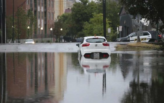
A car stalled in high water in the 600 block of East Crockett during the Sept. 4 record rainfall. With the ground already saturated, drivers are urged to be extra cautious and check the weather as they make their way home or pick up children from school in the afternoon and evening as a weather system moves through South Central Texas.
A car stalled in high water in the 600 block of East Crockett during the Sept. 4 record rainfall. With the ground already saturated, drivers are urged to be extra cautious and check the weather as they make
Photo: Jerry Lara /Staff Photographer
As a weather disturbance over the Gulf of Mexico makes its way into South Central Texas, meteorologists warned afternoon commuters to be on alert for flash flooding.
The system was expected to reach the Texas Gulf Coast early this morning, the National Weather Service said late Thursday.
NWS meteorologist Cory Van Pelt said San Antonio rain chances are forecast to increase throughout the day.
“If we get some heavy rain … areas around town could be flooding pretty quickly, especially before the afternoon commute,” Van Pelt said.
The weather system is expected to bring between 2 to 4 inches of rainfall, with isolated pockets up to 8 inches Friday through Sunday.
The rainfall this weekend could be enough to push San Antonio to, if not past, the record for the wettest September, the weather service said.
As of Thursday evening, the city has gotten 11.37 inches of rain, reaching the third-wettest September. The record is 15.78 inches set in 1946.
A flash flooding watch for 7 a.m. today to 7 p.m. Saturday evening has been issued for the Edwards Plateau, downtown San Antonio, Rio Grande Plains and Coastal Plains.
While the morning commute may be relatively quiet, drivers are urged to be extra cautious and check the weather as they make their way home or pick up children from school in the afternoon and evening.
San Antonio Fire Department officials urge commuters to have plans with their employers in case flooding prevents them from reaching their jobs.
SAFD spokesman Woody Woodward said the department cannot stress the “Turn Around, Don’t Drown” message enough.
Firefighters said a vehicle can stall out in just a few inches of water. After that, all it takes is a foot or two of water to float a 3,000-pound car downstream.
Meteorologists said that with the ground already saturated, it won’t take much rainfall this time around to cause flash flooding from rainwater runoff.
The weather service warned that the Rio Grande, the upper Nueces, Frio and San Antonio rivers are prone to flash flooding caused by heavy rain.
San Antonio residents can call 311 or dial 210-207-6000 to report weather-related issues including flooded streets, downed trees on public roadways, flashing or malfunctioning traffic lights, and low water crossings.
Bexar County also has a website to check for parts of roadways that have been closed as a result of flooding — www.bexarflood.org.
Jacob Beltran is a reporter covering San Antonio and Bexar County. Read him on our free site, mySA.com, and on our subscriber site, ExpressNews.com. | | Twitter: @JBfromSA
