- Weather Impact Alert: Brad Panovich updates severe weather risk on Sunday
- Big March storm system threatens US with tornadoes, blizzards and wildfire risk
- As city leaders consider expanding at-risk zone for wildfire damage, home builders say it could raise costs
- Is your neighborhood at high wildfire risk? | Here's how to check the city's wildfire risk map
- 'Be prepared now': Brad Panovich updates severe weather risk for Sunday
Dorian now a Hurricane, forecast to target Southeast United States
CHARLOTTE, N.C. — Here’s the latest on Hurricane Dorian
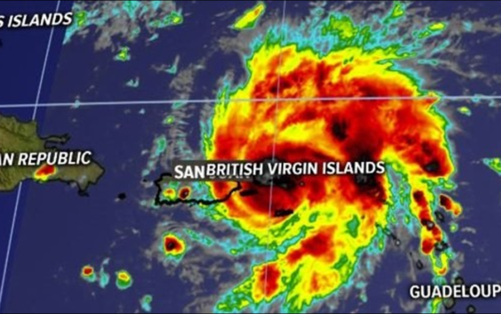
As of the 2 p.m. et update from the National Hurricane Center
LOCATION: OVER ST. THOMAS
CATEGORY: ONE
MAXIMUM SUSTAINED WINDS…75 MPH
MOVEMENT…NW AT 13 MPH
Dorian is a category one hurricane with sustained winds of 75 mph, according to the 2 p.m. update from the National Hurricane Center. It has wind gusts up to 90 mph.
The storm is located directly over St. Thomas and is moving northwest at 13 mph. It is already impacting the Virgin Islands and Puerto Rico.
Intense rainfall could lead to flash flooding in the U.S. and British Virigin Island along with Puerto Rico.
Dorian is becoming a lot more organized and will continue to intensify, according to First Warn Chief Meteorologist Brad Panovich.
By Thursday, the storm is expected to continue northwest into open water, where it will feed off of warmer waters and continue to strengthen.
As it passes to the north of the Bahamas, it is expected to strengthen into a Category 3 storm, which would make it a “major hurricane” with sustained winds of at least 111 mph.
There remains uncertainty in the forecast this many days out – – but the best indication is the storm will make a landfall along Florida’s eastern coast or coastal Georgia early next week. The uncertainty, which is commonly portrayed in the forecast track’s “cone of uncertainty,” will shrink as the storm moves closer to shore.
RELATED: 5 Things to Know About Hurricane Dorian
Panovich said everyone living along the Southeast coast should be paying attention. The track could shift.
“Residents in these areas should ensure that they have their hurricane plan in place and not focus on the exact forecast track of Dorian’s center,” according to the National Hurricane Center.
Regardless of where the storm ultimately makes landfall, heavy rain can be expected in portions of the Bahamas, Florida, Georgia, and South Carolina.
Residents leaving along the shore should also monitor dangerous storm surge and rip currents, which are also a threat along coastal North Carolina because of Tropical Depression Erin.
Current Hurricane Dorian warnings
Hurricane warnings have been issued for Vieques and Culebra, the U.S. Virgin Islands and the British Virgin Islands. A hurricane watch is in effect for parts of Puerto Rico, as well. Other parts of Puerto Rico are now under both a Hurricane Watch and a Tropical Storm Warning.
Tropical-storm-force winds are currently extending out up to 80 miles from Dorian’s center.
RELATED: Airlines offer travel waivers as Dorian reaches hurricane strength
Tropical Depression Erin
Tropical Storm Erin remains 190 miles off the coast of Cape Hatters, North Carolina.
The storm, which has sustained winds of 35 mph, is moving to the northwest at 13 mph. It is not expected to make a landfall in the United States.
Some strengthening is occurring, according to the National Hurricane Center. The storm could become what is defined as an “extra-tropical” storm as it moves toward Nova Scotia Thursday. An “extra-tropical” storm still contains the strength of a tropical system but inherits the title as it moves northward out of the tropics.
RELATED: Person struck by lightning in Marion, numerous tress toppled during storms
RELATED: Lightning strikes kill 5, injure over 100 in eastern Europe’s Tatra Mountains
RELATED: Extensive tree damage in Statesville after severe weather
RELATED: Two rescued from flooded car during Charlotte storms