- Cast of Scandal reunites to show support for western North Carolina after Hurricane Helene
- Tropical Storm Sara threatens to bring flash floods and mudslides to Central America
- Hurricane-stricken Tampa Bay Rays to play 2025 season at Yankees' spring training field in Tampa
- Utah scores 3 goals in 2 1/2 minutes in 3rd, Vejmelka has 49 saves in 4-1 win over Hurricanes
- Driver dies after crashing off hurricane-damaged highway in North Carolina
Tropical Storm Fernand forms in Gulf of Mexico as it moves toward South Texas, NE Mexico coasts

HOUSTON — Tropical Storm Fernand has formed in the Gulf of Mexico, and people along the lower Texas Coast and northeastern coast of Mexico should monitor its progress.
IThe Government of Mexico has issued a Tropical Storm Warning from La Pesca to Barra del Tordo and from Barra El Mezquital to the Mouth of the Rio Grande River.
At 2 p.m. Houston time,. Fernand’s winds were 40 mph and it’s Rmoving west at 7 mph.
In Houston, we don’t have to worry much about it as the forecast track has it continuing westward. But our friends and neighbors in South Texas and in Mexico will want to keep a close eye on it.
RELATED: Hurricane Dorian weakens slightly, begins turn to the northwest; blamed on 5 deaths
RELATED: Forecasters now monitoring four other tropical disturbances
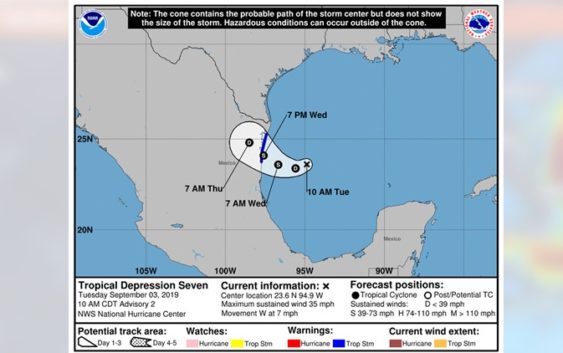
The system is expected to become a tropical storm by Tuesday night, according to the NHC. KHOU 11 Meteorologist Chita Craft says because this is cyclone number seven, it will be called Fernand when it becomes a tropical storm.
As of the 10 a.m. NHC update Tuesday maximum sustained winds were at 35 mph.
What does this mean for Texas?
For Houston, not much. But in South Texas and the lower Texas Coast they can expect two to four inches of rain through Friday with the potential for flash flooding. Mexico will get the worst of the weather with six to 12 inches of rain expected – the highest in the Sierra Madre Oriental of Tamaulipas and Nuevo Leon. Through Friday some parts of Mexico could get 15 inches of rain.

10 a.m. Tropical Depression Seven Update
NHC
10 a.m. advisory from NHC
DISCUSSION AND OUTLOOK:
At 100 PM CDT (1800 UTC), the center of Tropical Storm Fernand was located near latitude 23.5 North, longitude 95.3 West. Fernand is moving toward the west near 7 mph (11 km/h), and this motion is expected to continue today. A motion toward the west-northwest is forecast tonight and Wednesday. This motion could bring the center of Fernand near or over the coast of northeastern Mexico late Wednesday.
Recent satellite wind data indicate that the maximum sustained winds have increased to near 40 mph (65 km/h) with higher gusts. Additional slow strengthening is forecast before the system moves inland. A NOAA Hurricane Hunter aircraft is scheduled to investigate Fernand this afternoon to provide more information on the intensity.
Tropical-storm-force winds extend outward up to 105 miles (170 km) mainly to the west of the center.
The estimated minimum central pressure is 1004 mb (29.65 inches).
HAZARDS AFFECTING LAND:
WIND: Tropical storm conditions are expected to first reach the coast within the warning area during the day Wednesday, making outside preparations difficult or dangerous. Squalls with gusts to tropical-storm force are likely north of the warning area along portions of the northeastern coast of Mexico and the lower Texas coast.
RAINFALL: The system is expected to produce the following rainfall totals through Friday:
Northeast Mexico: 6 to 12 inches, isolated 15 inches, highest in the Sierra Madre Oriental of Tamaulipas and Nuevo Leon. This rainfall may cause life-threatening mudslides and flash floods.
South Texas and the Lower Texas Coast: 2 to 4 inches, isolated 6 inches.
RELATED: Florida officer rescues puppy ahead of Hurricane Dorian, names her ‘Dory’
RELATED: 1,400 more flights canceled Tuesday as Hurricane Dorian moves toward U.S.
RELATED: Hurricane Dorian weakens to Category 3 but still stalled near Bahamas