- Tornado outbreak leaves trail of destruction in Houston. Here's how to get help
- 1 killed, 4 injured in tornado-warned storm in Liverpool in Brazoria County
- 1 killed, 4 injured in tornado-warned storm in Liverpool in Brazoria County
- East Tennessee could see Hurricane Helene relief through property tax exemption proposal
- NWS: 5 tornadoes touched down in Houston area on day after Christmas
Hurricane Dorian once again a 'major' hurricane with 115-mph winds

ST. PETERSBURG, Fla — After a period of weakening, Hurricane Dorian’s winds have increased as it moves into a favorable area of development.
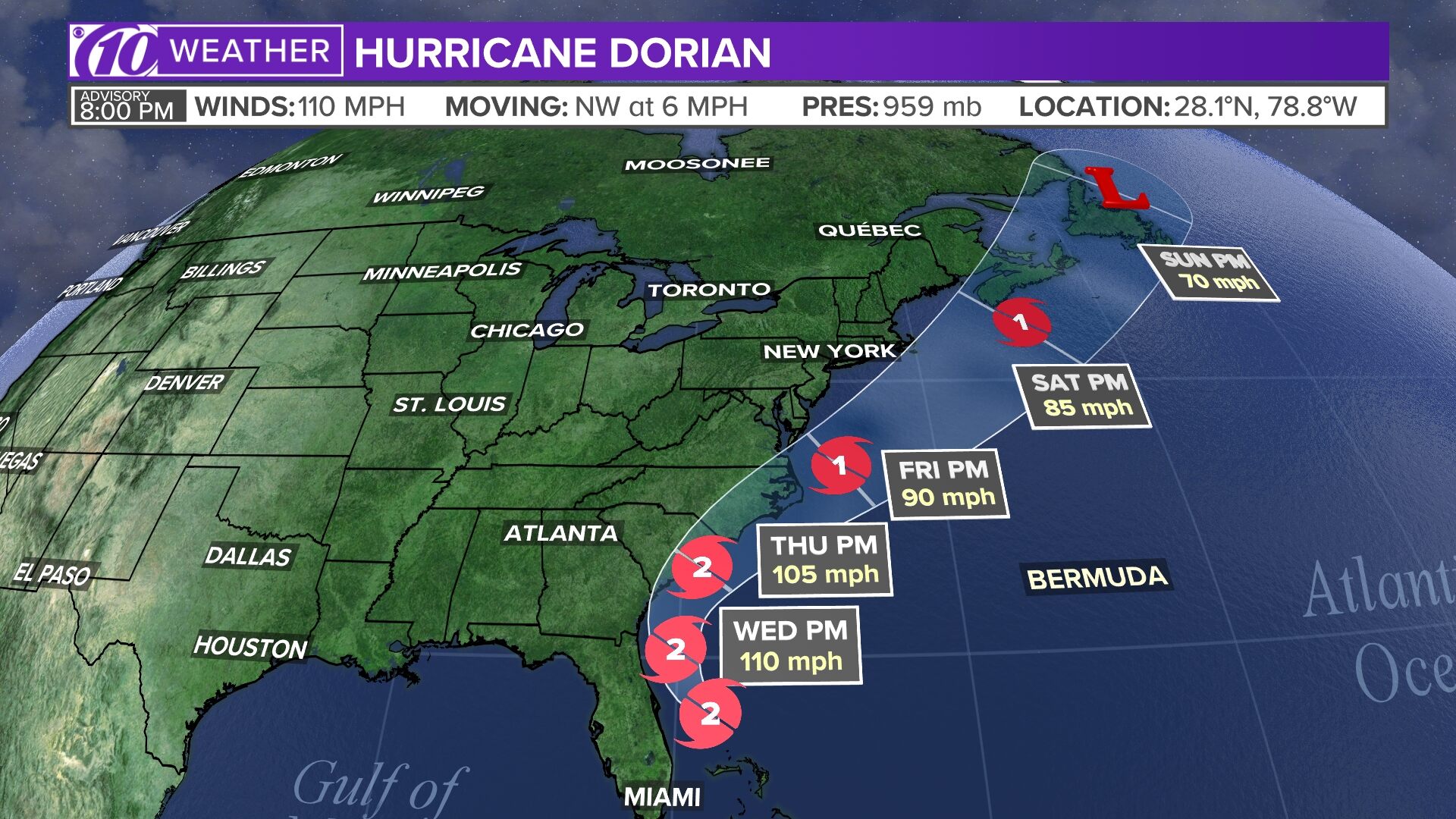
Major Category 3 Hurricane Dorian, with maximum sustained winds of 115 mph, is located about 105 miles south of Charleston, South Carolina, according to the National Hurricane Center’s latest advisory. It is moving to the north at 7 mph.
Its minimum central pressure, an indication of the storm’s strength, is 955 mb. Typically, the lower the pressure, the higher the wind speed. The pressure has gone down some since earlier advisories.
LIVE BLOG: The latest, need-to-know information on Hurricane Dorian
People on the U.S. coast are making final preparations for Hurricane Dorian as the storm makes its way north. At least 20 deaths have been reported in the Bahamas, with the full scope of the disaster still unknown.
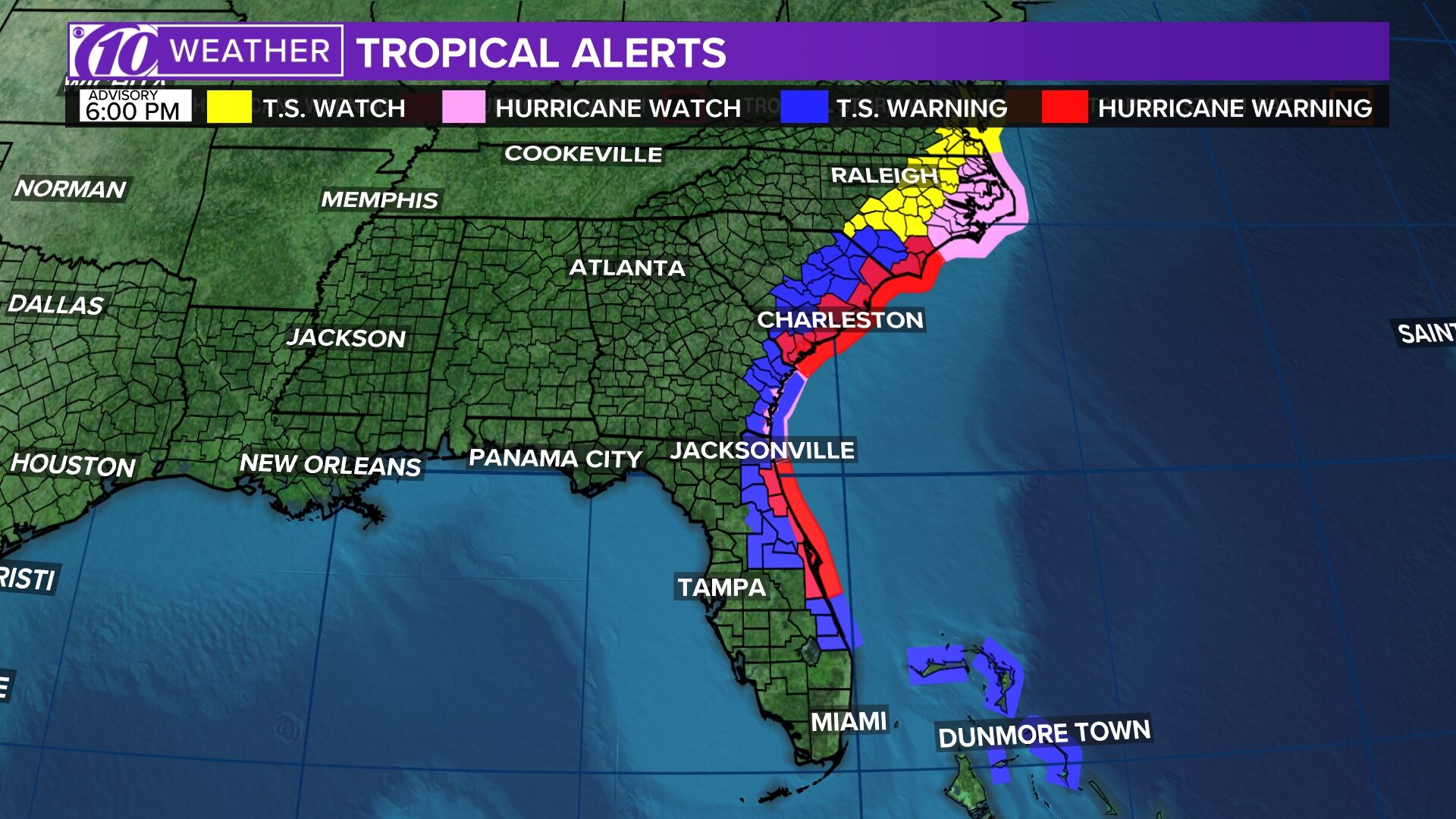
Hurricane watches and warnings were expanded Wednesday along the U.S. southeast coast. They include:
- Storm surge warning: Mouth of St. Mary’s River to Poquoson VA, Pamlico and Albemarle Sounds, Neuse and Pamlico Rivers, Hampton Roads
- Hurricane warning: North of Savannah River to the North Carolina/Virginia border, Pamlico and Albemarle Sounds
- Hurricane watch: Mouth of St. Mary’s River to Savannah River
- Tropical storm warning: Mouth of St. Mary’s River to Savannah River, North Carolina/Virginia border to Chincoteague VA, Chesapeake Bay from Smith Point southward
- Tropical storm watch: North of Chincoteague VA to Fenwick Island DE, Chesapeake Bay from Smith Point to Drum Point, Tidal Potomac south of Cobb Island
RELATED: What’s the difference between a hurricane watch and a warning?
Dorian first made landfall in Elbow Cay, Bahamas, around 12:45 p.m. Sunday with maximum sustained winds of 185 mph as a Category 5 hurricane. Hurricane Dorian’s falling wind speeds since then made it a Category 4 storm Monday morning. From there, it weakened further.
However, Dorian remains an extremely destructive storm.
Stay tuned to the latest forecast as Dorian’s track and intensity become more certain.
►Track the weather and get severe alerts when they happen: Download the 10 News app now.
►Stay informed with all tropical weather: Check out our must-have interactive Hurricane Headquarters guide here.
Spaghetti models
Each line represents a computer model’s best “guess” of where the center of the storm will go. Together, they look like spaghetti noodles. Remember, impacts from a tropical system can and do occur miles away from the center.
App users — tap here if you cannot see the image below.
Tropical track
This is the latest “cone of uncertainty,” which shows an area where the center of the storm could go, when and how strong it might be at the given time.
App users — tap here if you cannot see the image below.

Watches and warnings
What’s a watch? What’s a warning? Here are the official alerts that can be issued for your area and what you should do.
App users — tap here if you cannot see the image below.
