- Fake job seekers are flooding the market, thanks to AI
- One set of evacuation orders lifted in Caldwell County after wildfire contained
- 'We gutted every building' | Chimney Rock rebuilding after Hurricane Helene
- 'We gutted every building' | Chimney Rock rebuilding after Hurricane Helene
- Debris from Hurricane Helene provides fuel, complicates containment for spring wildfires
Severe weather approaches Texas coast

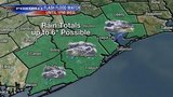
HOUSTON (FOX 26) – A flash flood watch is in effect from 1 p.m. Tuesday through 1 p.m. Wednesday for several Houston-area counties. This means that condition are favorable for flooding, and some areas could pick up 4″ to 6″ of rain.
According to the National Weather Service Houston/Galveston, a system in the Gulf will bring thunderstorms to the area through Thursday. Officials say people should expect showers and thunderstorms, heavy downpours, and possible street and small stream flooding.
There is still uncertainty on how strong & where exactly the system will be on Wed/Thurs. Where exactly the heaviest bands will set up is unknown right now, so don’t focus on specific rainfall amounts at specific places. A difference of a few miles can make a big difference. pic.twitter.com/WY7BCgm9CW
— NWS Houston (@NWSHouston) September 17, 2019
MORE: Houston-area weather forecast
From 1 a.m. to 7:30 a.m. Tuesday, the NWS said areas southeast of Houston from Taylor Lake Village and Armand Bayou to League City had already received over 2 inches of rain. More rain is expected.
Rain was heavy overnight and parts of Harris and Galveston counties received over 2 inches of since 1 AM. More rain is expected today. pic.twitter.com/x7dDKGPS4a
— NWS Houston (@NWSHouston) September 17, 2019
Governor Greg Abbott says he has placed resources on standby across the state. The State Operations Center has been elevated to level 3 Increased Readiness.
Governor Abbott says the Texas Division of Emergency Management will be rostering four Texas A&M Task Force One Boat Squads in Southeast Coastal areas, and the Texas Parks and Wildlife Department will also be moving boats to support the Beaumont area and adjacent regions.
“As severe weather approaches the Gulf Coast, the state of Texas is taking necessary precautions to ensure local officials have the resources they need to respond this event,” said Governor Abbott. “State assets have been positioned for quick deployment in the regions expected to be impacted by these storms and I encourage all Texans in the southeast coastal area to heed all warnings from local officials and pay close attention to weather reports as this system approaches.”
MORE: Severe Weather Watches & Warnings
Ready Harris encourages the public to monitor the weather and avoid travel during heavy downpours.
They shared the following reminders about traveling in the rain:
- If you must travel, never drive into high water and use extreme caution at underpasses and low-lying areas where water accumulates.
- Always remember to Turn Around, Don’t Drown! DO NOT DRIVE through high water and DO NOT DRIVE AROUND BARRICADES.
- Just two feet of water can sweep your vehicle away.
With integrated GPS, the FOX 26 Weather App “Follow Me” option will track you anywhere you go, and you can enable weather alerts in your county. Download the app for free.