- 'Everybody has to come out and do their part' | People pitch in to help tornado ravaged school in Alvin prepare temporary campus
- District collecting donations after tornado destroys elementary school in Alvin
- Lowe’s to distribute free tornado cleanup supplies in Kingwood Tuesday
- North Carolina extends FEMA aid deadline for Hurricane Helene victims
- ‘Am I dead? Is she dead?’ | Survivors recount terrifying moments after EF-3 tornado tore through Porter Heights
Tropical Depression 10 forms in Atlantic

TAMPA, Fla. (FOX 13) – Hurricane Humberto continues to gain strength out in the Atlantic, but the new Tropical Depression 10 may be of more interest to meteorologists here in Florida.
As of the midday Tuesday update, Hurricane Humberto had reached Category 2 strength with winds of 100 mph. The storm should remain on an east-northeast path out to sea and degenerate into a non-tropical low over the weekend, with rip currents on the East Coast the only real concern for the U.S.
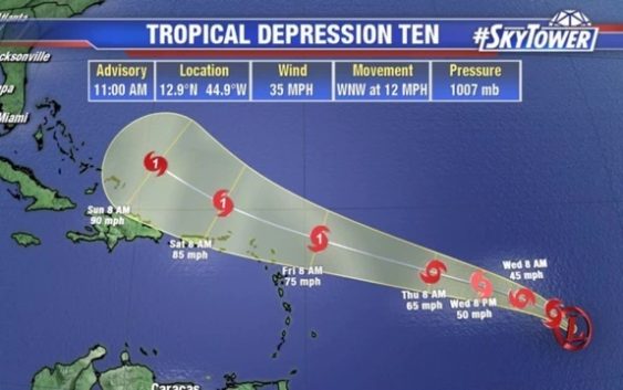
Further south, Tropical Depression 10 formed Tuesday morning in the central Atlantic. Forecasters expect it could reach tropical storm status by the evening – “Jerry” is the next name on the 2019 list – with slow but steady strengthening over the next few days.
Because the system is still forming, its track is harder to predict. But forecasters say it should continue moving west, likely sitting north of Puerto Rico on Saturday.
“I know you’re looking at that track and saying, ‘Hey, on Sunday, that’s going to be close to the Bahamas,’” FOX 13 meteorologist Jim Weber offered. “It does look like it’s going to be very similar to the last couple of tracks here where it finds that weakness in the ridge but the East Coast trough should turn this more to the north as we get into next week.”
LINK: Track the tropics on MyFoxHurricane.com
This afternoon, Tropical Storm Imelda formed just off the Texas coast and made landfall just minutes later. The National Hurricane Center says the system is expected to drop significant amounts of rain over Texas — 5 to 10 inches or even more in isolated areas.
Meanwhile, long-range forecast models suggest several more tropical waves forming in the Atlantic, still only a few days after the statistical peak of hurricane season.
“We’re kind of in a period where we’re going to see a lot of activity with more and more of these waves working their way off the coast of Africa, and conditions are favorable so we’ll quite likely see a lot more development over the coming days,” Weber added.