- Lighter winds help crews fighting wildfires in South and North Carolina
- Austin is at a 'potentially historic' risk of wildfires Tuesday. Here's how to prepare.
- South Carolina's governor declares State of Emergency as massive wildfire grows to 1,600 acres
- Staying weather alert: How to find your safe place during severe weather
- Wildfires persist across Carolinas amid windy, dry conditions
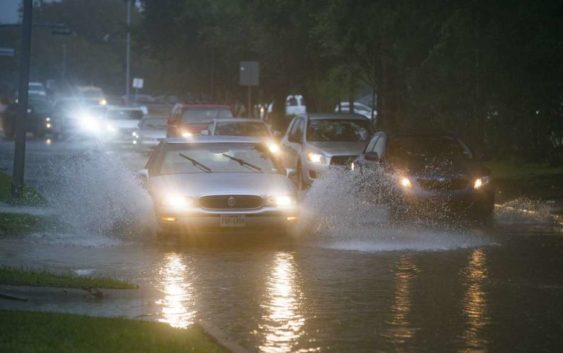
Flash flood threat from Imelda continues for much of Houston
-
Cars splash through heavy water filling Chimney Rock south of Brays Bayou in Houston, Tuesday, Sept. 17, 2019. A tropical depression in the Gulf of Mexico became Tropical Storm Imelda Tuesday afternoon as it made land south of Houston. lessCars splash through heavy water filling Chimney Rock south of Brays Bayou in Houston, Tuesday, Sept. 17, 2019. A tropical depression in the Gulf of Mexico became Tropical Storm Imelda Tuesday afternoon as it … more
Photo: Mark Mulligan, Staff Photographer
Cars splash through heavy water filling Chimney Rock south of Brays Bayou in Houston, Tuesday, Sept. 17, 2019. A tropical depression in the Gulf of Mexico became Tropical Storm Imelda Tuesday afternoon as it made land south of Houston. less
Cars splash through heavy water filling Chimney Rock south of Brays Bayou in Houston, Tuesday, Sept. 17, 2019. A tropical depression in the Gulf of Mexico became Tropical Storm Imelda Tuesday afternoon as it … more
Photo: Mark Mulligan, Staff Photographer
The threat of flash flooding continues throughout Southeast Texas, even as Tropical Storm Imelda was downgraded to a tropical depression.
Want to share your weather photos and video with Chron.com? Send them to newstips@chron.com
The National Weather Service extended the flash flood watch for Harris, Galveston, Brazoria, Chambers, Fort Bend, Matagorda, Liberty and Wharton counties until at least Thursday morning. Authorities are urging anyone to think twice before going on the wet roadways Wednesday morning.
Parts of southeast Harris County have received more than 9 inches of rain since early Tuesday morning, with central and northwest Harris County receiving 2 to 4 inches, according to the Harris County Flood Control District.
“We’ve had quite a bit of rainfall over the last 24 hours,” Harris County Flood Control District Meteorologist Jeff Lindner said early Wednesday. “The good news is that it’s fallen over a long-enough period of time to where we haven’t had any significant flooding.”
All of the bayous are running high Lindner said, especially in southeast Harris County. But they’re all within their banks.
Meteorologists haven’t received any reports of structures flooding, Lindner said.
“The flood threat’s probably going to be increasing a little bit today compared to yesterday,” he said, because the ground is saturated.
Several high-water spots have popped up across the area, according to Houston TranStar. Those spots include along the Gulf Freeway at El Dorado Boulevard and at Clear Lake City Boulevard on the frontage roads, while other spots include West Loop 610 at South Post Oak and South Beltway 8 and Mykawa.
That list does not include any surface streets that typically flood.
The system that became Imelda formed quickly Tuesday afternoon over the Gulf of Mexico and at 1 p.m. made landfall in Freeport with maximum wind speeds of 40 mph.
The Houston-area experienced the first of two periods of concentrated rain Tuesday night into Wednesday morning and a second is predicted Wednesday night into Thursday morning, forecasters say. The area could receive 4 to 7 inches of rain through Thursday, with totals reaching 12 inches in some areas, Lindner said.
The rate of rainfall, up to 1 to 2 inches per hour, is concerning, he added.
Even as the system continues to weaken during the next few days, chances for rain in the Houston area will last until early next week.
Jay R. Jordan covers breaking news in the Houston area. Read him on our breaking news site, Chron.com, and our subscriber site, HoustonChronicle.com | Follow him on Twitter at @JayRJordan | Email him at jay.jordan@chron.com