- A Columbus County man saves a couple and their dog from flooding waters
- Governor Cooper visits Southport following widespread flooding and road closures
- Why North Carolina has a fall wildfire season
- Stoney Creek Plantation residents dealing with severe flooding again, six years after Florence hit
- Carolina Beach continues to deal with flooding following Monday’s storm
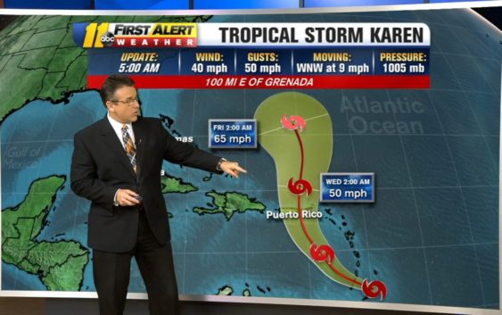
Tropical Storm Karen forms in Atlantic Ocean
Tropical Storm Jerry will continue on a northwesterly path through Sunday before gradually turning north, then northeasterly this week. this path would take the storm very close to Bermuda later Tuesday into Tuesday night. It’s possible that Jerry regains hurricane strength by this time. Jerry will threaten Bermuda with heavy rain, strong winds, flooding and wind damage during this time.
Jerry will then quickly accelerate away from Bermuda on Wednesday and Thursday as it transitions into a non-tropical cyclone as it becomes absorbed in the westerlies.
2019 hurricane season: This year’s storm name list
Meanwhile, Humberto is now a powerful non-tropical cyclone racing eastward away from Atlantic Canada. Humberto will quickly cross the North Atlantic over the next couple of days, threatening shipping interests across the region. By later Monday into Monday night and Tuesday, Humberto could bring locally heavy rainfall and gusty winds to parts of the British Isles as it crosses the region.
Tropical Storm Karen has formed and if forecast to move northwest over the next 5 days. By Friday a slight bend to the west is possible as the EURO and other global models take Karen and push it towards the Bahamas. pic.twitter.com/M1tEOAhtpF
— Steve Stewart (@StewartABC11) September 22, 2019
Tropical Storm Karen formed east of the Lesser Antilles early Sunday morning. Karen will push across the Lesser Antilles through Monday and then take a turn northward toward Puerto Rico and the Virgin Islands.
With moderate wind shear over the storm, Karen should remain a tropical storm as it passes across the Caribbean this week. Gusty winds and locally heavy rainfall are expected across parts of the eastern Caribbean along its path.
Another tropical system, just off the African coast, is expected to form by the early part of this week. This should strengthen into at least a tropical storm in which it will be given the name Lorenzo. This storm should take a northward path over the open waters of the Atlantic and not be an immediate threat to land.
Copyright © 2019 ABC11-WTVD-TV/DT. All Rights Reserved – The Associated Press contributed to this report.