- National memorial to honor NC firefighter who died on duty during Hurricane Helene
- Gov. Josh Stein extends State of Emergency for western NC wildfires
- Governor Stein extends state of emergency for NC wildfire threat
- Governor Stein extends emergency in 34 NC counties amid wildfire threat
- Texans can buy emergency preparation supplies tax-free April 26-28 ahead of severe weather season
At least one tornado confirmed in Dallas-Fort Worth metro area
This is a breaking story that will be updated throughout the night.
Severe storms developed in the Dallas-Fort Wort metro area on Sunday night. The system brought hail, lightning and at least one confirmed tornado, first spotted north of Love Field in Dallas around 9 p.m.
A tornado warning is in place for parts of Ellis, Dallas and Collin counties until 10 p.m. Sunday. One warning was issued for northern Dallas County and southern Collin County. This was for the same tornado that moved through North Dallas.
Another warning was issued for southern Dallas County and northern Ellis County.
Residents in all these areas should seek shelter — move away from windows and move as low as possible.
A few storms have breached the cap ahead of the cold front. Any storms that develop have the potential to produce large hail, damaging winds and an isolated tornado.
Check this link for all of the latest storm warnings and watches.
Download our free WFAA app to stay up-to-date on all news stories in the Dallas-Fort Worth area, including weather.

WFAA
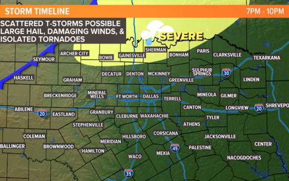
See below for a detailed timeline of what to expect later this evening.
TONIGHT (10 P.M. – MIDNIGHT)
Scattered storms from earlier in the night will start to form a line during this time. The areas that will see the best chance for storms during this time will be western and northern North Texas.
The threat of severe storms will continue. Large hail and damaging winds will continue to be the main threats, but we can’t rule out an isolated tornado.

WFAA
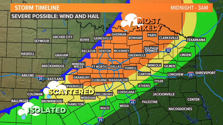
SUNDAY NIGHT TO MONDAY MORNING (MIDNIGHT TO 3 A.M.)
A line of thunderstorms will start to sweep across North Texas.
Severe storms are possible with this line of storms as well. Damaging winds and large hail will be the main threats. We can’t rule out a spin-up tornado within the line. But since the storms will be in a line, the tornado threat is much lower.
WFAA
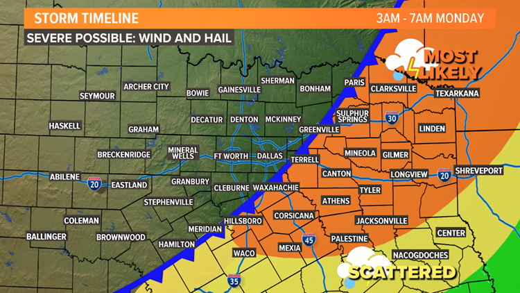
EARLY MONDAY MORNING (3 A.M TO 7 A.M.)
The round of storms will continue to move from west to east across North Texas. But storms will also end from west to east.
The closer to sunrise Monday, the farther east the storms will be. By daybreak Monday, most storms will be in East Texas.
WFAA
REST OF THIS WEEK
Monday will be cooler and breezy behind the cold front. Most of next week will be very fall-like.
Another front is due to arrive Thursday into Friday, bringing back chances for showers and storms. That front could have even cooler air behind it with much cooler temperatures by Friday into next weekend.