- Fake job seekers are flooding the market, thanks to AI
- One set of evacuation orders lifted in Caldwell County after wildfire contained
- 'We gutted every building' | Chimney Rock rebuilding after Hurricane Helene
- 'We gutted every building' | Chimney Rock rebuilding after Hurricane Helene
- Debris from Hurricane Helene provides fuel, complicates containment for spring wildfires
Tornado spotted in Dallas Sunday night
This is a breaking story that will be updated throughout the night.
At least one tornado touched down Sunday night near Dallas Love Field.
The severe storm system brought hail, lightning and high-speed winds through the area. A tornado was spotted around 9 p.m. north of the Dallas airport.
The National Weather Service will assess storm damage Monday and confirm how many tornadoes touched down Sunday night.
Heavy damage was reported in the Preston Hollow area, including at the home of Dallas Stars center Tyler Seguin.
RELATED: Dallas Stars Tyler Seguin’s house destroyed in tornado
Tornado warnings for parts of Ellis, Dallas, Collin, Rains and Van Zandt counties had expired Sunday as the storms continued to move east.
A severe thunderstorm warning was in place for Kaufman and Van Zandt counties until 11:30 p.m.
A second system of storms moved through the region later and a tornado watch was in place until 2 a.m.
As of 12:24 a.m. Monday, no serious injuries or fatalities were reported to the city of Dallas.
The City of Dallas is currently assessing the damages of the city.
“Residents are encouraged to stay indoors if they are in an area with storm damage due to downed trees, power lines and debris,” a statement from the City of Dallas read early Monday morning.
RELATED: DFW weather: Dallas Fire-Rescue responding to structure collapse at Harry Hines and Walnut Hill
Check this link for all of the latest storm warnings and watches.
Download our free WFAA app to stay up-to-date on all news stories in the Dallas-Fort Worth area, including weather.
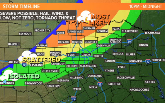
See below for a detailed timeline of what to expect overnight.

WFAA
SUNDAY NIGHT TO MONDAY MORNING (MIDNIGHT TO 3 A.M.)
A line of thunderstorms will start to sweep across North Texas.
Severe storms are possible with this line of storms as well. Damaging winds and large hail will be the main threats. We can’t rule out a spin-up tornado within the line. But since the storms will be in a line, the tornado threat is much lower.
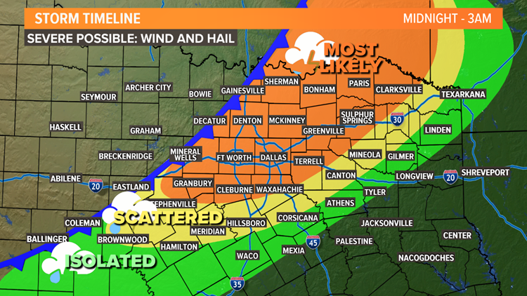
WFAA
EARLY MONDAY MORNING (3 A.M TO 7 A.M.)
The round of storms will continue to move from west to east across North Texas. But storms will also end from west to east.
The closer to sunrise Monday, the farther east the storms will be. By daybreak Monday, most storms will be in East Texas.
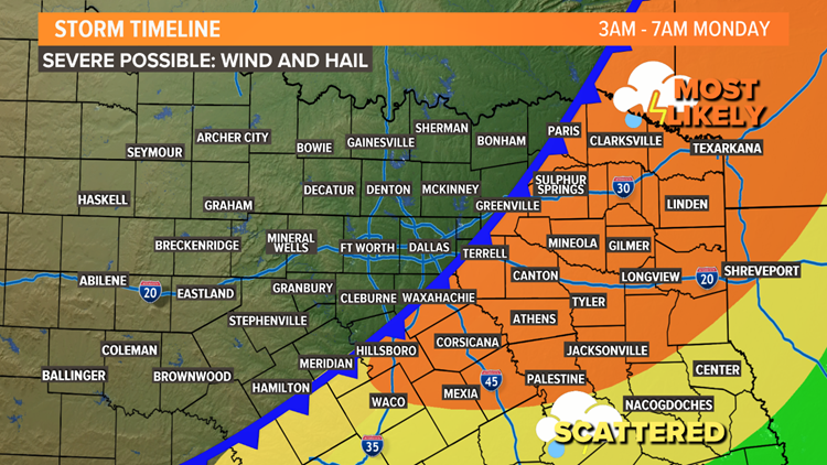
WFAA
REST OF THIS WEEK
Monday will be cooler and breezy behind the cold front. Most of next week will be very fall-like.
Another front is due to arrive Thursday into Friday, bringing back chances for showers and storms. That front could have even cooler air behind it with much cooler temperatures by Friday into next weekend.