- Fake job seekers are flooding the market, thanks to AI
- One set of evacuation orders lifted in Caldwell County after wildfire contained
- 'We gutted every building' | Chimney Rock rebuilding after Hurricane Helene
- 'We gutted every building' | Chimney Rock rebuilding after Hurricane Helene
- Debris from Hurricane Helene provides fuel, complicates containment for spring wildfires
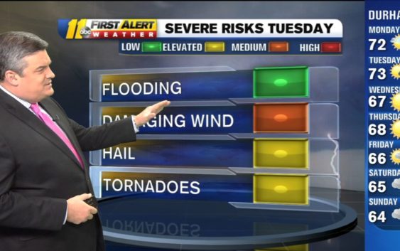
Severe storms could bring damaging winds on Tuesday
We are watching for the risk of severe weather on Tuesday.
Most of our area is in a Cat 2 of 5 (Slight) Risk for severe weather tomorrow (Tuesday). Biggest threat=damaging winds. Could also see some hail or an isolated tornado. #ncwx pic.twitter.com/gAUX0pyljW
— Don Schwenneker (@BigweatherABC11) October 21, 2019
A potent cold front will swing through and bring a line of storms that put the entire viewing area under some level of risk.
Most of the area is under a category 2, or slight, risk according to the Storm Prediction Center.
As far as the type of threats:
Here a First Alert to the various threats for Tuesday in our viewing area. I think damaging straight line winds are the biggest, but we will have to watch for a pocket of hail or an isolated tornado. #watching pic.twitter.com/arsvhXVLMm
— Don Schwenneker (@BigweatherABC11) October 21, 2019
Many places may not see severe weather, but the potential is there, that’s why we are giving you a head’s up. Now let’s look at the timing.
This timing certainly could change depending on the speed of the storms and how the front interacts as it moves through the mountains. Rainfall totals should be around a 1/2-inch or less, so not really worried about flooding. Do watch out for the leaves on the roads though! Once they gather in an area and get wet, it’s just like stopping on ice! Stay safe.
Copyright © 2019 WTVD-TV. All Rights Reserved.