- North Carolina legislators fleshing out details on $500M in additional Hurricane Helene relief
- Dangerous travel conditions: Ice, snow and flooding possible
- How photos lost in disasters like Hurricane Helene find their way home, with a little help from people who care
- Dangerous travel conditions, ice/snow and flooding possible in the mountains Tuesday and Wednesday
- Weather Impact Alert: Dangerous travel conditions, ice/snow and flooding possible in the mountains Tuesday and Wednesday
Tornado warning issued for Johnston, Wayne, Sampson counties
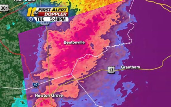
A tornado warning has been issued for parts of Johnston, Sampson and Wayne counties until 6:45 p.m.
The storm is moving eastward at 35 mph.
A line of storms moved in from the west, bringing the possibility of strong wind gusts.
Most of the ABC11 viewing area is in the “marginal” risk area for severe weather, which is a level 1 out of 5.
The severe threat is now down to a marginal risk, level 1 out of 5. Gusty winds are possible in the strongest storms this afternoon. pic.twitter.com/DJMpv3XbLo
— Brittany Bell (@BrittanyABC11) October 22, 2019
Some powerful wind gusts are still possible Tuesday as storms move through this afternoon. There will be a line of showers, but no lightning expected.
Temps will top out in the low to mid-70s for much of the area. Some localized flooding or a small pocket of hail is possible as well, but are not big threats this afternoon.
Isolated showers hit during the morning with scattered rain developing through the middle of the day. Pop-up storms will develop in the afternoon for the next couple of hours, until about 8 p.m., before moving on into the Coastal Plain through sunset.
It will clear later, with lows in the 45-50 degrees range.
It should be sunny tomorrow, with highs in the mid-60s to 70s and lows in the 42-47 range.
Stay with ABC11 on-air and online for the latest developments.
Copyright © 2019 WTVD-TV. All Rights Reserved.