- 'Everybody has to come out and do their part' | People pitch in to help tornado ravaged school in Alvin prepare temporary campus
- District collecting donations after tornado destroys elementary school in Alvin
- Lowe’s to distribute free tornado cleanup supplies in Kingwood Tuesday
- North Carolina extends FEMA aid deadline for Hurricane Helene victims
- ‘Am I dead? Is she dead?’ | Survivors recount terrifying moments after EF-3 tornado tore through Porter Heights
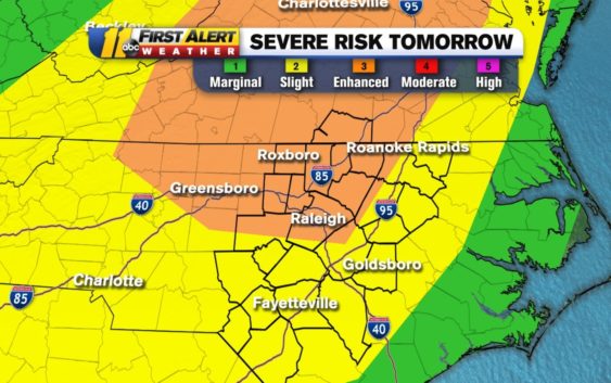
Enhanced risk of severe weather for parts of NC on Halloween

We did start this month with a 100-degree day! Now, we are about to see another swing over the next couple of days. 80 degrees on Halloween, freezing temps by Sunday. And when we see those big shifts in an air mass, we usually get storms. Thursday will be one of those days.
Because of the possibility of severe weather, the SPC put us in a Category 3 of 5 (enhanced) Risk for severe storms on Halloween.
The latest severe threat for Thursday is now upgraded to an enhanced risk along and North of the Triangle. Damaging winds are the main threat, but an isolated tornado is also possible. The strongest storms move through late Thursday evening after trick-or-treating wraps up. pic.twitter.com/zffkdBAFEY
— Brittany Bell (@BrittanyABC11) October 30, 2019
As the storms roll through, they will be damaging winds will be the main threat.
With us under a slight risk for severe weather on Halloween, thought I’d talk threats. Biggest threat=damaging wind. Can’t rule out an isolated #tornado, but will not see a big outbreak. pic.twitter.com/Oc0iWfyqk6
— Don Schwenneker (@BigweatherABC11) October 30, 2019
We may even see some severe weather in the storms popping ahead of the mainline. We also can’t rule out an isolated tornado, but the bigger threat will be the straight-line wind. As far as the timing goes…
Now this is just one model, and one model does not make a forecast. Several of the models are leaning toward a late evening or overnight passage of this line of storms. This is subject to change depending on the heating of the day and the frontal interaction with the mountains as it moves West to East. It’s something we will keep an eye on all day long and update as we get new data in. Thursday will be a very good day to stay Weather Aware.
Copyright © 2019 WTVD-TV. All Rights Reserved.