- As city leaders consider expanding at-risk zone for wildfire damage, home builders say it could raise costs
- Is your neighborhood at high wildfire risk? | Here's how to check the city's wildfire risk map
- 'Be prepared now': Brad Panovich updates severe weather risk for Sunday
- 'Be prepared now': Brad Panovich updates severe weather risk for Sunday
- As anxiety around wildfires grows, Austin plans to add tens of thousands of acres to risk map
Damaging winds possible as strong storms move into Triangle

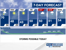
Raleigh, N.C. — Strong thunderstorms are expected to roll into the Triangle early Tuesday afternoon, as parts of North Carolina are under a level 1 threat for severe weather.
A level 1 threat means isolated severe thunderstorms are possible, and they’ll be limited in intensity and duration, according to the National Weather Service.
The storms are part of a system that’s responsible for three deaths in Louisiana and Alabama. Suspected tornadoes destroyed buildings and brought trees down throughout the Deep South on Monday.
But the system has weakened significantly as it’s moved toward North Carolina. While damaging winds are possible in North Carolina on Tuesday, the storms won’t be as destructive, WRAL meteorologist Elizabeth Gardner said.
Warmer weather has settled into North Carolina, with temperatures in the 60s early Tuesday afternoon. High temperatures will reach 70 degrees around lunchtime in Raleigh and Durham.

“Anytime in the wintertime when it feels this warm and humid, we often expect to see those thunderstorms,” Gardner said. “We tend to see a lot more of those in the spring, but often in the wintertime we do see those when we see these big clashes of our air masses.”
Some rain could fall during the morning commute, Gardner said, but heavier rain and thunderstorms are expected to develop around lunchtime.
The worst of the thunderstorms in the Triangle are expected in the early afternoon. Rain will linger as the system continues moving east, and while the evening commute could be wet, the heaviest of the storms should be over.
Things will get much colder as skies clear Tuesday evening.
“Temperatures crash behind this front,” Gardner said.
Tuesday’s overnight lows will plunge to 34 degrees.
Wednesday’s high will reach 48 degrees, and lows will drop into the mid-20s.