- Recovery continues for western NC nearly two months after Hurricane Helene
- Recovery continues for western NC nearly three months after Hurricane Helene
- Cast of Scandal reunites to show support for western North Carolina after Hurricane Helene
- Tropical Storm Sara threatens to bring flash floods and mudslides to Central America
- Hurricane-stricken Tampa Bay Rays to play 2025 season at Yankees' spring training field in Tampa
Wind, Hail, and Isolated tornadoes possible Friday

AUSTIN, Texas — The second of two cold fronts this week will bring on a different weather pattern.
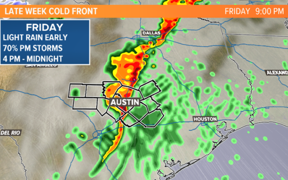
As a strong cold front approaches from the west on Thursday, rain chances will be small with isolated showers possible mainly east of Austin. When the front approaches Interstate 35 on Friday, widely scattered showers and thunderstorms will take shape.
Here’s a look at the timeline and the side effects of this system.
RELATED:
Allergy Alert: Cedar pollen remains very high in Central Texas
As of now, the cold front looks to arrive late Friday afternoon and evening and will move across Central Texas through the overnight hours. The front will then move across the Gulf states on Saturday, increasing the severe weather threat along Mississippi and Alabama.

KVUE
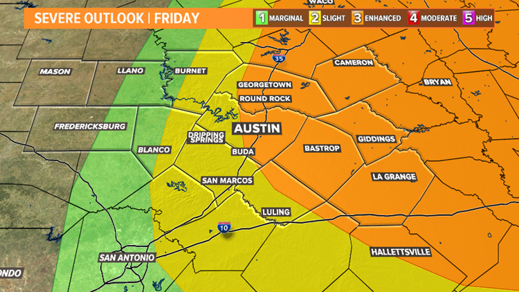
The Storm Prediction Center has highlighted areas along I-35 for the potential of severe weather. The highest potential for widespread severe weather is highlighted in orange which includes Austin, Dallas, Houston and Waco.
Strong storms cannot be ruled out in the green and yellow shaded areas, but will likely be less numerous.


KVUE
Threats with this system include strong damaging winds in excess of 60 mph and small hail. The threat for an isolated tornado is not ruled out, especially with storms that develop ahead of the main line of thunderstorms. The environment in East Texas and central Mississippi-Arkansas is capable of supporting tornado development late Friday into Saturday.
The heaviest rain is expected northeast of our area where the severe threat is highest. Central Texas will see less than an inch of rainfall for most locations.


KVUE
With any system capable of producing strong storms, being prepared is the best practice to stay safe. Stay with the KVUE Storm team as details get fine-tuned for Friday.
Expect breezy, dry and cooler conditions behind the front for this weekend.
Be sure to download the KVUE app to get the latest weather news straight to your phone. You can download it in the App Store or Google Play. Also be sure to follow KVUE on Facebook, YouTube, Twitter and Instagram for updates on the weather.
PEOPLE ARE ALSO READING:
Pflugerville man says he found a tracking device under his truck after video caught someone under it
Unsealed affidavit reveals what may have happened to Heidi Broussard before her death