- Bellaire police officer dies months after being injured during Hurricane Beryl cleanup
- Bellaire police officer dies months after being injury during Hurricane Beryl cleanup
- Why were there so many tornado warnings on Sunday, Dec. 29
- Solar eclipse, sunny day flooding, heat death: Here are the stories you read the most in 2024
- Hundreds of structures damaged and up to 10 people injured in Montgomery County tornado
Tumultuous weather pattern to renew river flooding fears in U.S.

Even though rain has become less frequent over portions of the South and the Ohio Valley in recent days, a stormy pattern during the first week of March may aggravate the flooding situation in some areas.
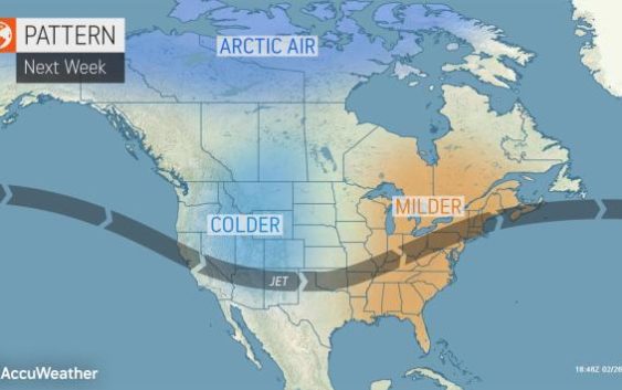
The stormy pattern will evolve as cold air that has settled over the eastern half of the United States late this week begins to retreat northward.
A large portion of the South Central and Southeastern states as well as the lower part of the Midwest has been targeted by relentless rainfall this winter.
Some locations from Mississippi to Kentucky and Indiana have picked up two to three times their normal rainfall, not only since the start of 2020, but also extending back into late 2019.
Jackson, Mississippi, where Pearl River flooding has forced evacuations this month, has received nearly nearly 30 inches of rain since Dec. 1, 2019, exactly two times the average rainfall during this timeframe.
Birmingham, Alabama, has picked up 26.17 inches of rain, nearly doubling the normal rainfall, since the start of December. Even locations farther north have been soaked, including Indianapolis, where rainfall has been nearly two times that of average since Jan. 1 with 9.2 inches pouring down.
Runoff from the storms has not only resulted in incidents of flash and urban flooding, but also river flooding.
Major flooding has occurred along portions of the Pearl, lower Mississippi and the lower Ohio rivers to name a few of the large rivers. Flooding has occurred along many secondary rivers from central Texas to the coastal plains of the Carolinas, Georgia and northern Florida.
Slightly longer breaks of dry weather have allowed the ground to dry out slightly, but in most cases, the ground is still very moist and will not be able to hold much water and meteorologists say that’s not good news given big rainstorms are expected in the next couple of weeks.
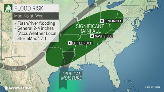
During the upcoming week, a series of storms could bring a general 2-4 inches of rain with an AccuWeather Local StormMax™ of 7 inches. The upcoming rainfall may occur over a large swath of the area that has been hit hard with rainfall and has experienced flooding this winter.

“The storms are projected to move along a frontal zone that will set up roughly from Texas to Maine during the early and middle part of next week,” AccuWeather Senior Meteorologist Brett Anderson said.
There is the risk that much of the projected rainfall can occur during a 24-hour period or less spanning Tuesday and Wednesday, which would be a greater mechanism for urban and small stream flooding as opposed to rain falling evenly over a three- or four-day period.
CLICK HERE FOR THE FREE ACCUWEATHER APP
“The bulk of the rain with the upcoming event seems likely to avoid part of the southeastern corner of the nation, but probably not so farther west and inland over the South,” he added.
Many rivers have already crested following the siege of rain from January to early February. Over the next several days, crests are forecast to occur on portions of rivers just inland from the coast such as the Savannah, Alabama, Pearl, Neuse and Mississippi.
The upcoming rain is likely to slow the rate of recession on many rivers, and it could bring a second rise on some of the rivers across the interior as it spurs new flooding along unprotected portions of waterways.
Portions of the South Central, Southeastern and Midwestern states will remain at risk for flooding moving forward well into this spring as melting snow up north, combined with more rain, brings new surges of water.
There will certainly be more storms over the coming weeks across the Central states, and as the temperature trends upward, the added factor of snowmelt comes into play.
Flooding during 2019 over the Central states affected nearly 14 million people along long stretches of the Missouri and lower Mississippi rivers, according to the New York Times.
While flooding may not be as extensive and perhaps not as severe in all areas that were hit hard in 2019, some of the same locations could be hit again, and some areas that were largely spared last year could be hit this spring.
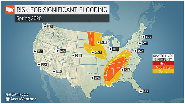
 This map shows the prime areas of concern for river flooding for the spring of 2020.
“The weather pattern this winter is already suggesting that the lower Mississippi, Ohio and Tennessee valleys will be problem areas moving forward this spring,” AccuWeather Lead Long-Range Meteorologist Paul Pastelok said.
Areas farther north will be at risk as well.
“As snow begins to melt, the ground thaws and locked-up water is released in portions of the lower Missouri, the upper part of the Mississippi and the Red River over the north, problems related to flooding are likely,” Pastelok said.
AccuWeather will continue to monitor both the short-term and long-term flooding situation and provide updates this spring.
Related video: How to prepare for a flood