- 'A little emotional': Hurricanes equipment manager got seconds in goal, memory to last a lifetime
- WMO retires three hurricane names after devastating 2024 season
- Beryl removed from future hurricane naming lists
- Hurricane names Helene, Milton and Beryl are now retired
- Hurricane Helene's name retired after deadly 2024 impact on US
5:30 a.m. Saturday update: Here’s what to expect today in the Triangle from Florence

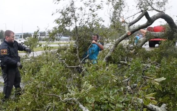
As the center of Tropical Storm Florence moved slowly into South Carolina overnight, the storm’s outer bands of rain pummeled the Triangle, causing creeks to rise and bringing down trees and limbs that blocked roads and dragged down power lines.
And the rain isn’t expected to stop anytime soon.
Florence will creep westward, with the center of the storm remaining in South Carolina, and as it does forecasters expect it will continue to funnel rain into the Triangle through Sunday. Wake, Johnston and Harnett counties are under a flash flood warning until 11 a.m. Saturday, and tropical storm warnings remain in effect for those counties along with Chatham and Franklin and points south and east.
More than 3 inches of rain fell at Raleigh-Durham International Airport between early Friday afternoon and daybreak on Saturday. In that time, Crabtree Creek rose nearly 9 feet at Wake Forest Road in Raleigh, nearly to the point where it overflows its banks.
Crabtree Creek should begin flooding along its course through Raleigh by mid-morning, said Jonathan Blaes, a meteorologist at the National Weather Service office in Raleigh.
The rain has been heavier south and east of the Triangle; by 3 a.m. Saturday, more than 8 inches had fallen in Benson, and Goldsboro had gotten more than 10 inches, according to the weather service. And just before 5 a.m., the weather service warned that another band of heavy rain was moving in to Johnston, Wayne and Sampson counties, with another 3 to 6 inches likely by mid-morning.
“That’s going to continue to just pound them all morning,” Blaes said. “There’s already flooding in those areas, and it’s just going to get worse.”
Rivers in Eastern North Carolina, including the Neuse, Cape Fear and Lumber rivers, are expected to rise to near record levels in the coming days. The Neuse left its banks in Goldsboro overnight and was expected to be at “major” flood stage by Saturday night, according to the weather service.
Some 800,000 homes and businesses began the day without power in Eastern North Carolina, including more than 29,000 in Wake and 26,000 in Johnston, according to Duke Power.
Blaes said the heaviest rain may begin to ease up in the Triangle by Saturday night, but showers and intermittent rain will continue Sunday. The National Weather Service forecast doesn’t call for sunny skies to return until Tuesday.
Despite the lingering rain and wind, there are signs of life getting back to normal in the Triangle. GoRaleigh, which ceased bus service Thursday evening in anticipation of the storm, says it will resume its regular schedule Saturday, as will GoDurham. GoTriangle and GoCary will begin their normal Saturday schedules at 8 a.m.
Airlines that had canceled most or all of their flights on Friday at Raleigh-Durham International Airport said they expected to resume operations on Saturday. But Amtrak trains remain canceled through the weekend.
Tweet to @newsobserver and tell us what you’re seeing in your neighborhood.