San Antonio Begins Its Weekend With High Winds, Heavy Rain

A wave of severe storms roared into South Central Texas late Friday evening and early Saturday morning. They were part of a massive storm system that stretched across Texas, from Mexico to Oklahoma.
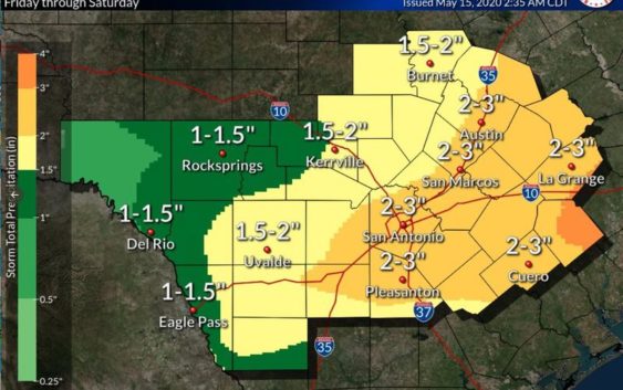
The National Weather Service reported on Saturday that the storms dropped an inch-and-a-half of rain over most of Bexar County. Two to three inches of rain fell on parts of Comal County.
Half inch hail was reported in Blanco, Marion and at Lakehills in Medina County.
Emergency management officials reported high winds knocked down some trees and power lines in Uvalde.
The NWS tracked the “squall line” as it moved into the Hill Country around 10 p.m. Friday.
By 11 p.m., the communities around San Antonio, New Braunfels, Schertz, Pleasanton, Floresville and Jourdanton all faced severe thunderstorm warnings.
Heavy and steady rainfall lashed the San Antonio area, and blinding flashes of lightning instantly turned night into day throughout early Saturday morning.
The bulk of the rain has moved east, but we are now seeing high gusts (over 40mph in Kerrville) in the line’s wake. Also, lighting strikes up to 30 miles behind the back end of the stratiform rain shield. pic.twitter.com/zxqL9tKp4C
— NWS Austin/San Antonio (@NWSSanAntonio) May 16, 2020
But the storms moved quickly through the area. By sunrise, San Antonio was drenched but peaceful.
Saturday’s forecast was partly sunny skies and highs in the 80s. The week ahead promised more sunshine and highs in the 90s.
The storm system was taken seriously. Throughout Friday evening, the NWS tweeted out maps of West Texas and radar gifs illustrating the wave of storms sweeping eastward. Yellow was the color of the severe thunderstorm watch, which stretched from Laredo to the Texas-Oklahoma border.
It can be difficult or impossible to see flooding at night. There is no way to gauge how deep the water may be. NEVER drive through flooded roadways! Turn Around, Don’t Drown! pic.twitter.com/Gvecr2tpge
— NWS Austin/San Antonio (@NWSSanAntonio) May 16, 2020
CPS Energy also monitored the storms throughout Friday evening and Saturday morning. It tweeted out the standard tips to any customers who lost power: Stay away from downed power lines. Do not drive over any downed lines because they may still be live. Never enter standing water in a flooded home or other building unless you’re sure the main power is off.
If possible, customers could report outages and monitor the extent of area-wide outages with the CPS Outage Map.
At around 2 a.m., it tweeted that it was aware around 5,700 customers had lost power, and crews were working to address the outages. By 10 a.m., most of the outages had been repaired.
#SanAntonio, we have your back should the severe storms result in power outages!
When the storms roll in, we roll out!
For the latest updates, follow:
OUTAGE CENTER https://t.co/4rxlduGvAw
STORM PREPARATION https://t.co/XWxQ1BcGIU pic.twitter.com/TJwjTjZSY6
— CPS Energy (@cpsenergy) May 15, 2020
Gov. Greg Abbott announced on Friday that he had activated state resources to assist with any emergencies and damages related to the weather.
“The State of Texas has placed these resources on standby as a precautionary measure to help respond to any potential severe weather and protect Texans across the Lone Star State,” Abbott’s office explained. “Over the weekend, Texans should pay attention to weather alerts and heed guidance from their local officials as these storms cross our state.”
But on Saturday morning, clear skies, sunny weather and a drying region made those resources mostly unnecessary.
The NWS reported San Antonio in 2020 was only about an inch and a half behind average rainfall totals. But the Edwards Aquifer level is only a foot about the mark where stage one water restrictions are triggered.
Norma Martinez and Fernando Ortiz Jr. contributed to this report.
Brian Kirkpatrick can be reached at Brian@TPR.org and on Twitter at @TPRBrian.
TPR was founded by and is supported by our community. If you value our commitment to the highest standards of responsible journalism and are able to do so, please consider making your gift of support today.