- California wildfire burns out of control but firefighters could get a break when winds diminish
- 'Flooding is our number one natural disaster' | Breaking down the voter-approved Harris County Flood Control District tax rate hike
- Powerful Category 3 Hurricane Rafael knocks out power in Cuba as it heads to the island
- NC Forest Service warns of increased wildfire risk in western part of state after Helene
- First responders searched for hours after being told two people were swept away in flash flood
Tropical Storm Arthur crawls closer to U.S. coast

-
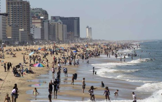
Warm weather draws crowds to the oceanfront, Saturday, May 16, 2020 in Virginia Beach, Va. (Kaitlin McKeown/The Daily Press via AP)
Warm weather draws crowds to the oceanfront, Saturday, May 16, 2020 in Virginia Beach, Va. (Kaitlin McKeown/The Daily Press via AP)
Photo: Kaitlin McKeown, AP
Warm weather draws crowds to the oceanfront, Saturday, May 16, 2020 in Virginia Beach, Va. (Kaitlin McKeown/The Daily Press via AP)
Warm weather draws crowds to the oceanfront, Saturday, May 16, 2020 in Virginia Beach, Va. (Kaitlin McKeown/The Daily Press via AP)
Photo: Kaitlin McKeown, AP
MIAMI (AP) — Life-threatening surf and rip currents will spread along U.S. East coast beaches in the days ahead as Tropical Storm Arthur kicks up ocean swells offshore, the National Hurricane Center warned on Monday.
It’s another early start for the Atlantic hurricane season: Arthur formed Saturday in waters off Florida, marking the sixth straight year that a named storm has developed before June 1.
GETTING HOT: Houston could see record high temperatures this week
The Hurricane Center said Arthur is expected to move near or just east of the coast of North Carolina, where up to 3 inches (7.6 cm) of rain was expected Monday before turning away from the East Coast Tuesday. A Hurricane Center advisory said that Arthur was bringing “heavy rains and gusty winds,” and some isolated areas could see higher rain totals.
At 8 a.m. EDT, the storm’s center was located about 50 miles (80 kilometers) east-southeast of Morehead City, North Carolina. Arthur had top sustained winds of 45 mph (75 kph) and was moving to the north-northeast at 24 mph (22 kph).
A tropical storm warning was issued for parts of North Carolina’s coast, from Surf City to Duck, including Pamlico and Albemarle Sounds, and heavy rainfall is expected for much of the eastern part of the state, said Michael Lee, a meteorologist with the National Weather Service in Newport, North Carolina.
“The main threat that we’re really trying to get out there is that there is enhanced risk for dangerous rip currents both today and tomorrow. So, any folks who want to try to go to the beach and get in the water, we have a high risk out for most of our beaches,” Lee said.
The weather service said eastern North Carolina should prepare for some localized flooding and dangerous marine conditions along the coast.
BEACH PARTY: Crowds descend on Crystal Beach for Go Topless Jeep Weekend
“Minor inundation from storm surge is possible for very low-lying areas adjacent to the ocean, sounds, and rivers, with overwash of dunes and flooding of properties and roadways possible for locations where dune structures are weak,” mainly north of Cape Lookout, the weather service said.
While there may be a component of warming waters and climate change in other pre-June storms, Arthur is more of a subtropical storm system than a traditional named storm and its water is cooler than what’s usually needed for storm formation, said Colorado State University hurricane researcher Phil Klotzbach.
A lot of these out-of-season storms are weak fleeting ones that meteorologists can see now because of satellites and better technology and would have been missed in earlier times, Klotzbach said.
Local forecasters in the Bahamas said showers have lingered over the islands of Grand Bahama and Abaco, which are still struggling to recover after being hit by a Category 5 hurricane last year. Patients are being cared for in tents in Grand Bahama after Hurricane Dorian damaged the island’s hospital.
___
Associated Press writer Danica Coto in San Juan, Puerto Rico, contributed to this report.