- 'Flooding is our number one natural disaster' | Breaking down the voter-approved Harris County Flood Control District tax rate hike
- Powerful Category 3 Hurricane Rafael knocks out power in Cuba as it heads to the island
- NC Forest Service warns of increased wildfire risk in western part of state after Helene
- First responders searched for hours after being told two people were swept away in flash flood
- First responders searching for two people caught in flash flood
Tropical Storm Arthur brings more than 5 inches of rain to NC's coast

Carolina Beach, N.C. — Tropical Storm Arthur brought more than 5 inches of rain to parts of North Carolina’s coast Monday morning and should diminish this afternoon.
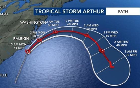
An 11 a.m. update from the National Hurricane Center showed Arthur passing just southeast of Cape Hatteras. While tropical storm warnings will continue into the afternoon for the Outer Banks, minimal damage is expected on land.
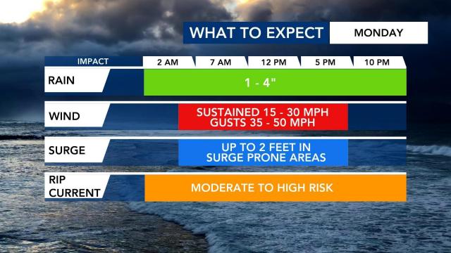
“The strongest wind gusts will remain offshore, but some gusts of 40-50 mph will be possible over the Outer Banks for the next couple of hours,” WRAL meteorologist Aimee Wilmoth said. Arthur will pull away from North Carolina’s coast by 2 or 3 p.m.
The highest wind gusts reported on shore so far were 43 mph winds at Cherry Point in Craven County. The highest rainfall report so far was 5.44 inches in Cape Carteret.
Wilmington and Carolina Beach began seeing heavy rain and crashing waves in the overnight hours as Arthur moved northeast. By 7 or 8 a.m., Emerald Isle and the Outer Banks were feeling the effects of the storm.
WRAL meteorologist Elizabeth Gardner said Wilmington and Carolina Beach saw heavy rain and crashing waves early Monday before the Outer Banks received the worst of Arthur when the storm makes its closest pass to the coast.
Arthur’s center will stay offshore, bringing mostly beach erosion and mild damage to the Outer Banks, and it is not expected to impact the Triangle apart from a few spotty showers.
The storm’s impacts included strong rip currents, scattered storms winds between 35-45 mph and localized storm surge up to 2 feet. Much of the Outer Banks saw up to 4 inches of rain, while some areas saw more.
Gardner said the Outer Banks could see impacts from Arthur through the afternoon before the storm pushes out to sea. “By lunchtime, it will be moving away, and by 8 p.m., the storm will be out of here,” she said.
Gardner said coastal homes should not be damaged by the storm, but beach erosion could occur. Swimmers and surfers should avoid the ocean Monday.
Carolina Beach Ocean Rescue Captain Tony Wallace said, despite coronavirus social distancing guidelines, officials made the decision to put a small number of lifeguards on the beach over the weekend.
While the Triangle will only see light rain from Arthur, the cold front that will cause Arthur to turn east and move back out to the Atlantic will bring us more rain Monday night and much of the work week.
Tropical Storm Arthur is the first named storm of the Atlantic hurricane season, which officially begins June 1.
