- National memorial to honor NC firefighter who died on duty during Hurricane Helene
- Gov. Josh Stein extends State of Emergency for western NC wildfires
- Gov. Stein extends state of emergency for NC wildfire threat
- Governor Stein extends state of emergency for NC wildfire threat
- Governor Stein extends emergency in 34 NC counties amid wildfire threat
High risk for flash flooding in Charlotte area
“It’s really cold over us and while that keeps the severe weather threat away from us, it actually increases our heavy rain threat,” said Brad Panovich.
CHARLOTTE, N.C. — The entire Charlotte area remains under a Flash Flood Watch through Thursday as heavy rain is expected to last in the mountains and foothills before more rain Wednesday.
“Everything is saturated,” said Chief Meteorologist Brad Panovich. “Even a light rain today would be a big problem.”
Panovich said there will be rain, heavy at times, for the next 12-18 hours.
A Flash Flood Watch is in effect for portions of Piedmont and upstate South Carolina through Thursday morning. Panovich says several waves of heavy rain will likely move into the Charlotte area Wednesday with the heaviest coming in the afternoon and evening hours.
Panovich says Wednesday’s rain is going to be the worst, because of the already saturated ground from the rain Monday and Tuesday. The risk for flash flooding is high in Charlotte and extreme in the mountains.
Panovich believes those high rain totals in the mountains could cause problems along the Catawba River chain, where flooding is possible this week. Some areas have already seen over 7 inches of rain fro this system with at least another day of rain coming.
“Over a three or four day period, those totals start to add up,” Panovich said. “We’re at two-and-a-half inches in Charlotte already and it’s only Tuesday. Even if we see just another inch or two, that’s the most we’ve seen in a three or four day period in weeks.”
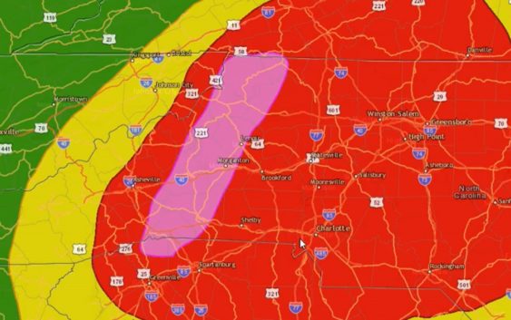
In the map below, the area shaded in red is a high risk for flash flooding with the mountains in an extreme risk.
Tuesday’s rainfall totals as of 10 p.m.
Charlotte: 2.5″
Boone: 2.6″
Shelby: 2.62″
Rock Hill: 1.5″
Albemarle: 1.94″
Monroe: 1.02″
The heavy rain is from a stalled system that will produce days of heavy rain showers and storms. It’s not going to be a total washout every day, but scattered showers and storms will bring heavy rain.
In the event of flooding, the National Weather Service would issue flood bulletins. The most severe conditions would warrant a Flash Flood Warning.
A Flash Flood Warning is issued when sudden, onset flooding is imminent or occurring. If you are in a flood prone area, you would be advised to move immediately to high ground. A flash flood is a sudden violent flood that can take from minutes to hours to develop.
It is even possible to experience a flash flood in areas not immediately receiving rain. Flooding can occur downstream or at lower elevations from where rainfall is occurring.
Be notified of Flash Flood Warnings in your area: Download the WCNC news or weather app to receive severe weather notifications for your location.
More news: