- Seven months after Hurricane Helene, Chimney Rock rebuilds with resilience
- Wildfire in New Jersey Pine Barrens expected to grow before it’s contained, officials say
- Storm damage forces recovery efforts in Lancaster, Chester counties
- Evacuation orders lifted as fast-moving New Jersey wildfire burns
- Heartbreak for NC resident as wildfire reduces lifetime home to ashes
Flooding threat, chilly winds will continue through Thursday
The rainy conditions we’ve had Wednesday will continue into Thursday with heavier rain chances just south of the Triangle.
WRAL meteorologist Kat Campbell said heavy rain chances will continue into Thursday along with breezy conditions. Most of the heavy rain has been off to the west but it’s expected to shift to the east, putting more of the area under risk for potential flooding.
iControl Interactive Doppler Radar
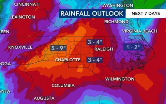
A flash flood watch is in effect for most of the viewing area through Thursday evening. An additional 3-5 inches of rain is possible and could lead to localized flash flooding.
“We could see some strong to severe storms,” Campbell said. “The biggest impact could be damaging wind gusts. Lightning and flooding will also be a concern. Everybody could see storms but the severe storms will likely be to the south.”
Campbell said we can expect anywhere from over an inch in the northern counties to as much as nearly four inches in southern areas like Southern Pines. Warmer air will begin to move into the area and push to the north.

“That’s why I think we’ll start to see our rain rates picking up,” Campbell said.
Rain chances will begin to subside Friday with a 20 percent chance of rain still possible Saturday and Sunday. Temperatures will begin to rise with it being in the low 80s this weekend and 77 on Memorial Day.
More than half of counties in the state are under a flash flood watch.
