- Austin adopts new map that greatly expands area at risk of wildfire
- CenterPoint Energy accelerates infrastructure improvements ahead of hurricane season
- Carolina Hurricanes playoff tickets go on sale Thursday
- Ask the Meteorologist: Why do tornadoes target Tornado Alley, Dixie Alley?
- Nonprofit closes distribution site that aided thousands after Hurricane Helene
Severe weather expected Monday with hail and flash flooding possible for San Antonio

-
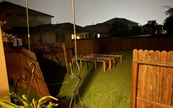
Damage to the fence of a San Antonio-area residence from storms that swept the city Sunday, May 24, 2020
Damage to the fence of a San Antonio-area residence from storms that swept the city Sunday, May 24, 2020
Photo: Courtesy
Damage to the fence of a San Antonio-area residence from storms that swept the city Sunday, May 24, 2020
Damage to the fence of a San Antonio-area residence from storms that swept the city Sunday, May 24, 2020
Photo: Courtesy
Severe weather is again expected for the San Antonio area Monday night after thunderstorms tore through south central Texas on Memorial Day weekend.
The National Weather Service issued a hazardous weather outlook for Monday into Tuesday morning and reported that another round of severe thunderstorms are expected Monday evening with a chance of isolated storms beginning in the afternoon.
Another 1 to 3 inches of rain is expected with up to 5 inches of rain possible in isolated spots. Flash flooding and river flooding are both possible Monday night. “The storms will develop late this afternoon, then gradually form into a cluster over the Rio Grande and Edwards Plateau this evening and and move across the Hill Country and I-35 corridor overnight to the U.S. 77 corridor by morning,” the NWS reported.
The NWS also cautioned San Antonio could see hail up to 1.5 inches in diameter and that damaging winds up to 60 miles per hour are possible. Meteorologists warn there could be significant damage to mobile homes, roofings, fences, windows and doors, large signs, trees and utility poles.
These storms come after a round of severe weather Sunday night prompted tornado warnings, flash flooding and caused minor property damage around the San Antonio area.
More than 42,000 people lost power Sunday night and nearly 650 people were still without power Monday morning, according to CPS Energy.
San Antonio Parks and Recreation also advised residents to stay off of trails Monday for safety reasons and to preserve the trails. In a tweet, they asked that people stay off the trails until they are dry.
[TRAIL NOTICE] Please use caution on trails before/after rain events. Don’t cross trails that are under water. Trails may have mud + debris after rains. For your safety + to prevent trail damage, please wait until trails are dry to resume activities. #TreadLightly #LoveYourTrails
— SAParksandRec (@SAParksandRec) May 25, 2020
Authorities also reported the Tube Chute Dam in New Braunfels was closed after heavy rain caused the Comal River to rise over the dam.
New Braunfels police said the fast-moving river reached more 500 cubic feet per second and so they closed the popular tubing feature until the water recedes and debris can be cleaned.
Temporary Closure of Comal River – Reevaluation at 11am Heavy rains last night have caused an increased flow of water…
Posted by New Braunfels Police Department on Monday, May 25, 2020
By Monday afternoon, 14 roads around Bexar County remained closed because of high water conditions, according to the San Antonio River Authority’s Bexar Flood project.
Taylor Pettaway is a breaking news and general assignment reporter for MySA.com | taylor.pettaway@express-news.net | @TaylorPettaway