- Country music's biggest stars hold 'Concert for Carolina' to help Hurricane Helene victims
- Jarvis stars as the Hurricanes beat the Kraken 4-1 for their 3rd straight win
- Houston Cougars take on A&M Aggies in charity exhibition game supporting Hurricane Beryl relief
- Hurricane Helene donations delivered to Avery County for Share the Warmth campaign
- Old Crow Medicine Show founder talks music, hurricane relief and this weekend's big benefit show
Tropical Storm Bertha makes landfall near Charleston, bringing heavy rain to North Carolina
Tropical Storm Bertha made landfall east of Charleston, South Carolina, by 9:45 a.m. and will bring heavy rain to North Carolina Wednesday and Thursday.
Tropical storm warnings were in place along South Carolina’s coast, but North Carolina will mainly see heavy rain from the storm. In North Carolina, the heavy rain could lead to flooding, and Moore and Chatham counties are under a flash flood watch until Thursday afternoon.
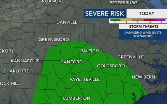
North Carolina could see widespread rain by lunchtime, and there will be a rip current risk along our coast. Much of the region, from the Triangle south, is under a level 1 risk for severe weather both Wednesday and Thursday, and severe weather and isolated tornadoes will be possible.
Bertha started off as a low pressure system and developed very quickly Wednesday morning thanks to warm ocean temperatures.
At 8:30 a.m., Bertha was 30 miles southeast of Charleston. The area could see up to 2.5 inches of rainfall an hour and wind gusts as high as 65 mph, but the storm will weaken quickly once it makes landfall by 10 a.m.

“It will quickly become a low pressure system once it hits land,” Gardner said. “The extent of this isn’t going to be widespread.”
Another system will keep rain falling in North Carolina Thursday, Friday and Saturday, tapering off early Sunday morning. The rain will be on and off or scattered at times.

“Right now, rain totals from now through Sunday morning can range between 1 to 3 inches with some locally higher amounts up to 4 inches,” Gardner said.
Since it has been several days since last week’s downpours, river heights are lowering and approaching their normal levels, but there is still a risk of flooding in some areas. Jordan Lake’s water level is higher than normal, already flooding a parking lot and causing damage to a boat ramp. Kerr Lake is 12 feet above normal. Falls Lake has rapids racing out of the dam.

“We should be fine in regards to the long-term flood threat, but due to high rain rates, flash flooding will have to be watched through the week,” Maloch said.